First Alert Forecast: Yellow Alert Sunday as Ophelia's remnants soak our area
NEW YORK - Tropical Storm Ophelia roared ashore in North Carolina early on Saturday morning with winds of 70 mph.

Ophelia brought lots of heavy rain, strong winds, and coastal flooding to various states across the Mid-Atlantic region.

Although our area did not bear the brunt of the storm, there have been some damaging effects regionwide. Luckily, these effects have mainly been just confined to the Jersey Shore.

At the Shore, widespread coastal flooding has been observed, along with wind gusts topping out over 60 mph in Ocean County. This is the same location that has seen the highest rainfall totals, with some places nearing 4 inches.

Ophelia has now transitioned into a "Post-Tropical storm", meaning she has lost her tropical characteristics. Nonetheless, Ophelia is still a storm, and will continue to deliver inclement weather to our region throughout Sunday and even parts of Monday as she slowly moves northward.
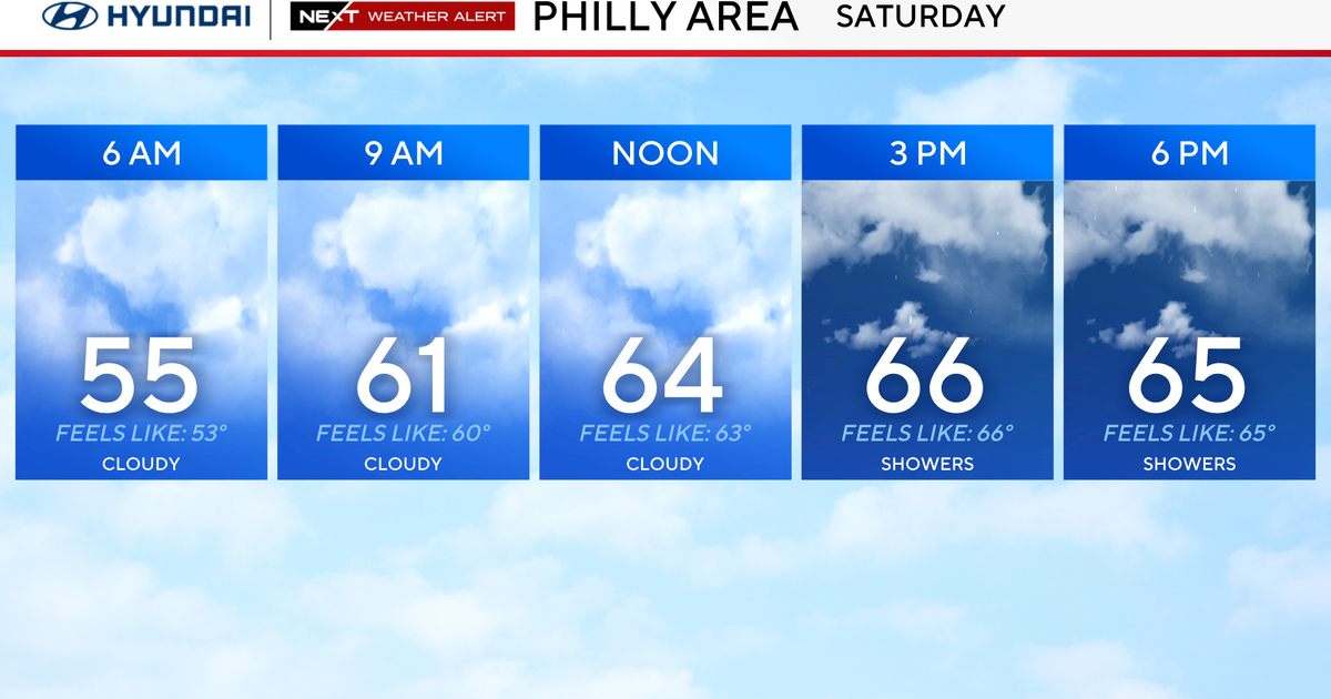
While what she delivers won't be as intense as what was seen on Saturday, it's enough to warrant a Yellow Alert for all of Sunday.
What To Expect:

More Rain: Rain will come in waves and be heavy at times. It's possible an isolated thunderstorm will be embedded within the heavier rain bands.

Additional rainfall looks to range between 1-3", with lesser amounts for the northwestern suburbs. Isolated flooding is possible.
Less Wind: As Ophelia continues to lose strength, the gusty winds will not disappear, they'll just be not as high as on Saturday. Instead of peak gusts exceeding 60 mph, they'll max out between 40-45 mph instead. The highest gusts are once again anticipated to happen at the Jersey Shore. Elsewhere, gusts will average between 15-35 mph. These gusts combined with a saturated ground may lead to more trees falling, which already happened on Saturday.

A Bit More Coastal Flooding: With Ophelia's center of circulation now far from the ocean, the threat of coastal flooding will not be as high as on Saturday. However, with the gusty winds still ongoing, flooding at the coast is still possible, with 1-2 feet of inundation. This would be most probable at the Jersey Shore, where Coastal Flood Advisories are in place.

So, we have about a day and a half to deal with the remnants of Ophelia before she finally departs by late Monday. Until the, expect dreary, damp, and cool conditions to prevail, with high temperatures mainly in the mid to upper 60s.