First Alert Forecast: Tracking a winter storm, Red Alert starting Monday evening
NEW YORK -- Following a cloudy start, Sunday turned out to be a very nice day. This winter's mild trend continued, with temperatures surging back into the 50s.
But things will soon be changing.
Skies will remain clear, and it will be cold Sunday night. The city will see a low of 32, while the suburbs will drop into the 20s.
Monday will start out clear but turn mostly cloudy as the next storm system advances into the region. The high will reach 42, but this complex storm has warranted the issuing of a Red Alert for the time period of Monday evening into the early afternoon hours of Tuesday. The storm is likely to bring widespread accumulating snow for many, while some will see a mixed bag of precipitation.
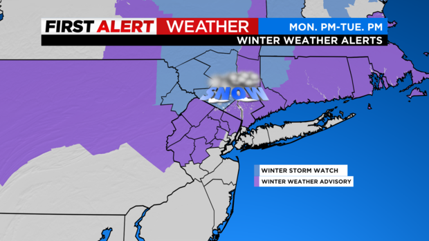
Storm Timeline:
Monday 4 p.m.-7 p.m.: Rain moves into the region, with some snow/sleet for our northern counties.
Monday 7 p.m.-10:30 p.m.: As cold air moves in, rain changes to snow for most, while the rain/snow line moves to the border of Monmouth and Ocean counties. The snow during this timeframe could be heavy at times, with rates up to an inch per hour. Winds will also ramp up, especially along the coast, with gusts up to 40 mph.
Monday 10:30 p.m.-Tuesday 2 a.m.: The rain/snow line shifts further north again, now along the South Shore of Long Island across to Central Jersey. Moderate snowfall is ongoing to the north of the line.
Tuesday 2 a.m.-7 a.m.: With the rain/snow line not really moving, a burst of heavier snow moves into the lower Hudson Valley and northern New Jersey.
Tuesday 7 a.m.- 1 p.m.: Rain/snow line moves north of the city, and precipitation starts to become lighter overall. Northwest New Jersey and the Hudson Valley will continue to see bursts of moderate snow.
Tuesday 1 p.m.-5 p.m.: Storm winds down, and skies begin to clear.
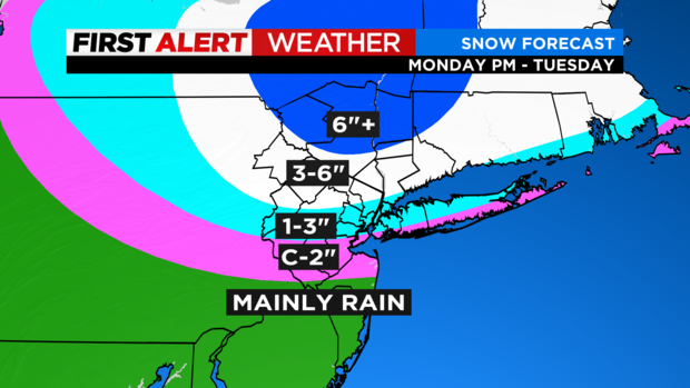
In terms of snowfall totals, the highest are likely to be found across northern New Jersey and the Hudson Valley, where some areas may see totals in excess of 6 inches. The city and surrounding locales should see a general 1-3 inches, with isolated higher totals, while areas south of the city and along the immediate coast, may only see an inch or less.
Due to the lack of snow so far this winter, this storm may prove more impactful than usual, simply because people just aren't used to it. It is also very likely that many schools will be closed on Tuesday. The CBS2 Weather Team will be tracking the storm carefully, and will be providing updates throughout the event.