Tornado watch canceled for Tri-State Area as remnants of Debby exit region. Here's the storm track and live radar.
NEW YORK – The tornado watch that had been issued for most of New York City's northern and western counties, including in New Jersey, has been canceled as the remnants of Debby move out of our area.
CBS New York's First Alert Weather team has canceled the Red Alert that had been in effect throughout the day.
The storm brought gusty winds and high surf, as well as flood risks in places already saturated from this week's rain, and it did prompt a brief tornado warning in Orange County, New York.
Interactive Weather Radar
Storms quiet down across Tri-State Area
The greatly weakened trailing front has moved onto Long Island. A few straggling showers are possible over the next hours, but it would be mainly light to moderate rain at best as the energy has faded. The atmosphere has really quieted down rapidly after such an active day.
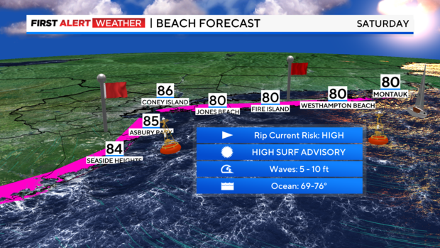
The oceans are still a concern with high surf and rip current alerts still in effect for a portion of Saturday. Please be careful if heading to the beach.
A gorgeous weekend awaits, and a mostly tranquil week is in store.