Weather woes forecast to continue as flooding in the Midwest turns deadly and extreme heat heads south
Millions of Americans sweated through a scorching weekend as temperatures soared across the U.S., while residents were rescued from floodwaters that forced evacuations across the Midwest. One person was killed during flooding in South Dakota, the governor said.
The National Weather Service said the worst of the heat wave would shift from the mid-Atlantic to portions of the southeast and southern Plains by Monday, brining welcome relief for major cities from Washington D.C. to Boston — but it may be short-lived.
Plenty of Americans were still sweating it out Monday, with more than 60 million people under heat advisories in 21 states. High temperatures were expected from South Dakota to Florida, and the heat is expected to start climbing again in the mid-Atlantic as the week goes on, even rising back toward triple digits by Wednesday.
Parts of the Midwest already inundated by floodwater, meanwhile, could see more significant rainfall in the days ahead.
Here is what we know:
Tornado confirmed in Northern Michigan
The National Weather Service on Monday confirmed that a tornado touched down in Northern Michigan over the weekend, as storms rolled through the region, CBS News Detroit reported. The tornado, which the weather service labeled an EF-1, hit fewer than 10 miles northeast of Michigan's Gladwin County on Saturday afternoon.
The EF Scale assigns a "rating" to tornadoes, on a scale of 0 to 5, based on the estimated wind speed and related capacity for damage of a given twister. A tornado labeled EF-1 generally carries winds between 86 mph and 110 mph. The one that struck Northern Michigan over the weekend reached peak wind speeds of 90 mph.
No deaths or injuries were reported in connection with the tornado.
Flooding kills 1 in South Dakota
At the borders of South Dakota, Iowa, and Minnesota, floodwaters rose over several days.
In South Dakota, Gov. Kristi Noem declared an emergency after severe flooding in the southeastern part. Several highways were closed. Areas south of Sioux Falls, the state's largest city, had an estimated 10 to 15 inches of rain over three days, National Weather Service hydrologist Kevin Low said.
At least one person died in the floods, Noem said Sunday, without providing details.
Several rivers, including the Big Sioux, James and Vermillion, were expected to peak sometime Monday through Wednesday night, the governor said at a news conference.
"I want to remind everybody to remember the power of water and the flow of water, and to stay away from flooded areas," Noem said. "We've got a few days in front of us here that'll be a little rough, but we'll get through it."
Emergency management officials in the small South Dakota community of Dakota Dunes on Sunday issued a voluntary evacuation order for the area's roughly 4,000 residents. Dakota Dunes is near the Nebraska and Iowa borders and is sandwiched between the Missouri and Big Sioux rivers, both of which are expected to crest in the coming days. Emergency management in Dakota Dunes warned residents that a mandatory evacuation could come quickly if flood barriers are breached.
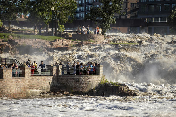
Intense rain has "catastrophic" effects in Minnesota
Minnesota Gov. Tim Walz described flooding across much of the state as "catastrophic," saying on Monday that heavy rainfall and overflowing lakes left "entire communities under feet of water."
In Waterville, a town situated between Lakes Tetonka and Sakatah about 70 miles south of Minneapolis, officials said flooding was the worst it had ever been in the area's recorded history. Walz declared a peacetime emergency for Minnesota on Saturday, allowing the Minnesota National Guard to deploy to assist in the state's response to the weather.
The emergency proclamation said that Waterville, in Le Sueur County, had been hit with between 14 and 18 inches of rainfall that caused water levels in the two surrounding lakes, as well as the nearby Cannon River, to rise to "uncontrollable levels." Residents of the area were evacuated as flooding caused "significant damage," the proclamation noted. On Sunday, CBS News Minnesota's Jason Rantala reported that water was continuing to rise "and officials say they don't know when it's going to stop."
1 killed, disaster declarations and evacuations in Iowa
At least one person was killed in Iowa flooding over the weekend. William Schulze, of Elburn, Illinois, was killed when his pickup truck was swept away as he tried to cross "rapid flood waters," the Clay County Sheriff's Office said. Rescue teams were unable to recover the body due to the dangerous conditions, the sheriff's office said.
In northwest Iowa, 13 rivers flooded the area, said Eric Tigges of Clay County emergency management. Entire neighborhoods — and at least one entire town — were evacuated, and the Iowa town of Spencer imposed a curfew Sunday for the second night in a row after flooding that surpassed the record set in 1953.
"When the flood gauge is underwater, it's really high," Tigges said at a news conference organized by Spencer officials.
Gov. Kim Reynolds declared a disaster for 21 counties in northern Iowa, including Sioux County. In drone video posted by the local sheriff, no streets were visible, just roofs and treetops poking above the water.
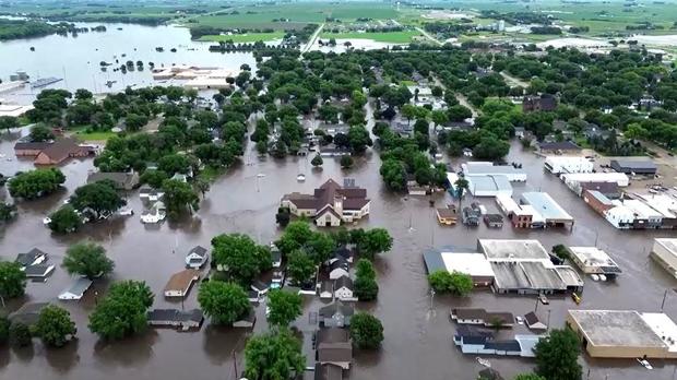
National Guard troops were helping with water rescues and transporting needed medications lost in flooding.
"Businesses are shuttered. Main streets have been impacted," Reynolds said. "Hospitals, nursing homes and other care facilities were evacuated. Cities are without power, and some are without drinkable water."
National Weather Service meteorologist Donna Dubberke said parts of northern Nebraska, southeastern South Dakota, southern Minnesota and northwest Iowa received eight times the typical average rainfall. And more heavy rain is expected in the week ahead.
CBS Minnesota's Jennifer Mayerle reported from Waterville that parts of the city were very literally underwater on Monday morning, and resident Lonnie Roemhildt said he'd heard the forecasts predicting even more rainfall.
"So, we're just bracing," he said. "And hopefully, it's not going to get any worse than this. It's ridiculous. I don't even know if there's a word for it. It's just unbelievable."
A state of emergency was in effect for the area, where as much as 18 inches of rain fell over the weekend. National Guard troops were expected to arrive Monday to and help residents cope with the rising flood waters.
Minor to moderate flooding was expected along the Missouri River, according to officials with the U.S. Army Corps of Engineers.
"As long as the levees hold, we're not expecting any major impacts," said John Remus, water management division chief for the corps in the Missouri River basin.
Elsewhere, the heat was the biggest worry.
Heat wave pushes south
The cities of Washington, D.C., Baltimore and Philadelphia all saw record heat, and both the nation's capital and Los Angles saw the mercury climb into the triple digits over the weekend.
From the beginning of the week, the stifling temperatures were expected to move to the south, but for many, caution would still be warranted.
"We still have this prolonged heat wave across portions of the Ohio Valley and into the Northeast," weather service meteorologist Marc Chenard said Sunday. "We get a little bit of relief by early in the week, at least in the eastern U.S., the Northeast, but in general above-normal temperatures are going to cover a large portion of the country even into next week."
"It's more important for people who are going to be outside to stay hydrated, because heat, humidity and low winds, even if you're in good shape and not really acclimated to it, it could be a danger," said Bruce Thoren, a National Weather Service meteorologist in Oklahoma. "It happens quickly."
Last year the U.S. experienced the most heat waves since 1936, experts said. An AP analysis of data from the Centers for Disease Control and Prevention found that excessive heat contributed to more than 2,300 deaths, the highest in 45 years of records.