Tropical Storm Fred could hit Florida, perhaps as hurricane, forecasters say
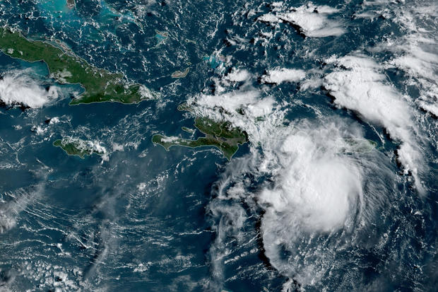
Tropical Storm Fred swirled toward the Dominican Republic and Haiti on Wednesday, with forecasters warning that heavy rains could cause dangerous flooding and mudslides. After a quiet month of no named storms in the region, Fred became the sixth of the Atlantic hurricane season late Tuesday as it passed by the U.S. Virgin Islands and Puerto Rico on a forecast track that would carry it toward Florida over the weekend.
Tropical storm warnings were discontinued in the U.S. territories after pelting the islands with rain. More than 13,000 customers were without power in Puerto Rico, where Luma, the company in charge of the transmission and distribution system, warned those who depend on electricity for life-saving medical devices to activate emergency plans.
"Puerto Rico's system ... continues to be very fragile," the company said, referring to the power grid Hurricane Maria destroyed in 2017.
Fred was centered 25 miles south-southeast of Santo Domingo, Dominican Republic, on Wednesday morning and moving west-northwest at 16 mph, the U.S. National Hurricane Center said. It had maximum sustained winds of 45 mph.
The Dominican Republic, Haiti and central and eastern Cuba could get hit Wednesday, and people in Florida were urged to monitor updates. Forecasters said the center of Fred was expected to move near the Turks and Caicos Islands and the southeastern Bahamas on Thursday, and move north of the northern coast of central Cuba on Friday.
CBS News weather producer David Parkinson said Fred's most likely path takes it over the Florida Keys as a tropical storm on Saturday morning, though a landfall either south of Miami or in the Upper Keys can't be ruled out.
If the storm takes that most likely path, it would then head into the Gulf of Mexico and intensify into either a stronger tropical storm or a weak Category 1 Hurricane, Parkinson said. Landfall would happen sometime between Sunday night and Monday midday on the Florida Panhandle, anywhere from Pensacola to the "Big Bend."
"The only thing that will be remembered about this storm is how much rain it will bring," Parkinson said. "Early projections show at least a half foot in the Keys and southwest Florida, and potentially 9 inches in the Panhandle.
As the storm moves inland, it could drop 6-plus inches in upstate South Carolina and western North Carolina. That part of North Carolina could see "devastating flash flooding," Parkinson said.
Puerto Rico Gov. Pedro Pierluisi closed government agencies on Tuesday at noon and officials noted that some gas stations had shut down after running out of fuel. The heaviest rain was expected to fall during the night, forecasters said.
Eight shelters were opened across the island, though officials said only about seven people had checked in by midevening.
"Do not wait until the last minute to mobilize," said Nino Correa, Puerto Rico's emergency management commissioner. "We don't want to have fatalities."
More than a month had passed since the last Atlantic storm, Hurricane Elsa, but this time of summer usually marks the start of the peak of hurricane season.
The hurricane center issued warnings for Dominican Republic on the south coast from Punta Palenque eastward and on the north coast from the Dominican Republic/Haiti border eastward. A watch was in effect for Haiti from the northern border with the Dominican Republic to Gonaives and for the Cuban provinces of Ciego de Avila, Camaguey, Las Tunas, Holguin, Granma, Santiago and Guantanamo. Also included in the watch was the Turks and Caicos Islands and southeastern Bahamas.
The storm was expected to produce rainfall of 2 to 4 inches (5 to 10 centimeters) over Puerto Rico and the Dominican Republic with up to 6 inches (15 centimeters) in some areas.


