Maps show Tropical Storm Francine's path and forecast after making landfall in Louisiana
Francine made landfall Wednesday evening along the Louisiana coastline as a Category 2 hurricane, threatening some communities still recovering from a particularly destructive hurricane season four years ago. President Biden has authorized an emergency declaration for Louisiana to support the state's response to the storm, the Federal Emergency Management Agency announced.
The storm made landfall in Terrebonne Parish, about 30 miles south-southwest of Morgan City, a little before 6 p.m. Eastern Time Wednesday, the National Hurricane Center said. It then quickly weakened to a tropical storm by late Wednesday night.
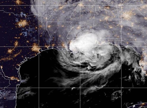
Prior to making landfall, the storm's intensification in the Gulf of Mexico triggered new hazardous weather alerts as far as the Florida border, although forecasters warned that consequences would mainly impact Louisiana, where "life-threatening storm surge and hurricane conditions" were being felt along the coast Wednesday.
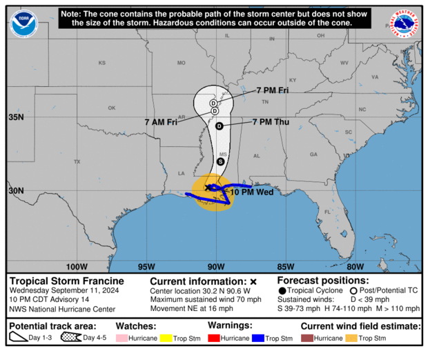
The storm is expected to continue weakening as it travels inland. As of 11 p.m. ET Wednesday, Francine's center was about 35 miles northwest of New Orleans, the hurricane center said. It was moving northeast at 16 mph, with maximum sustained winds of 70 mph.
Although the storm meandered earlier in the week, Francine had steadily picked up speed since Tuesday and started to turn toward the U.S. Gulf shoreline.
Several hurricane watches and warnings were discontinued. A tropical storm warning remained in place from Intracoastal City, Louisiana, to the Alabama/Florida border, which included the New Orleans metro area and Lake Maurepas and Lake Pontchartrain.
Hurricane and tropical storm warnings are activated when conditions typically associated with those weather events are imminent. Watches are different from warnings, which the hurricane center will issue for areas where severe weather conditions could possibly arrive within a couple of days.
Francine was forecast to bring heavy rainfall and possible flash flooding to parts of eastern Louisiana, Mississippi, southern Alabama and the western Florida Panhandle through Thursday.
The hurricane center earlier reported that "damaging and life-threatening hurricane-force winds" were forecast for portions of southern Louisiana Wednesday, and there was also the "danger of life-threatening storm surge for the Louisiana and Mississippi coastlines."
Storm surge warnings were in effect for the Louisiana coast from Avery Island east to the Mississippi-Alabama border and included Vermilion Bay, Lake Maurepas and Lake Pontchartrain.
If peak storm surge and high tide happen together, water levels from Burns Point to Port Fourchon, Louisiana, could rise between 5 and 10 feet above ground levels, the hurricane center said. Levels could reach 4 to 7 feet from Port Fourchon to the mouth of the Mississippi River, and 3 to 5 feet from Cameron to Intracoastal City near Vermilion Bay. Places along the Gulf coast from the mouth of the Mississippi River to the border of Alabama and Florida could see storm surges between 2 and 4 feet, according to the forecasts.
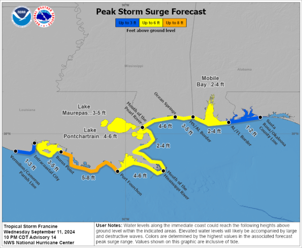
A storm surge watch means there is a possibility of life-threatening inundation in the watch area within 48 hours, and a warning means it could happen sooner.
Francine was also expected to dump 4 to 8 inches of rain on southeastern Louisiana, Mississippi, far southern Alabama and the Florida Panhandle through Thursday night, forecasters said, adding that up to a foot of rainfall could accumulate in certain areas. There was a risk of "considerable" flash flooding and urban flooding because of that, especially if storm surge linked to Francine compounds the tide to inundate coastal places.
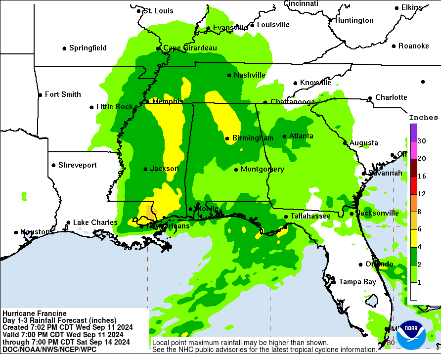
Flooding risks were highest for large sections of southeastern Louisiana, including New Orleans and the rest of the delta, and a strip of southwestern Mississippi, including the vast majority of the coast.
Forecasters said a few tornadoes could also materialize Wednesday and Wednesday night, possibly in parts of southeastern Louisiana, southern Mississippi, southern Alabama and the Florida Panhandle.