South Florida compared to scenes from a "zombie movie" as widespread flooding triggers rare warning
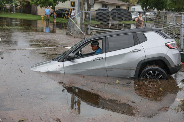
South Florida has been left in a state of emergency after days of rain have dumped more than a foot of rain on many parts of the region. The deluge created what's been likened to "zombie movie" scenes and triggered a rare warning from the National Weather Service as the precipitation continues on Friday.
"Looked like the beginning of a zombie movie," tow truck driver Ted Rico told the Associated Press. "There's cars littered everywhere, on top of sidewalks, in the median, in the middle of the street, no lights on. Just craziness, you know. Abandoned cars everywhere."
Rico, a lifelong Miami resident who has been helping clear the streets of stalled cars, said "every year it's just getting worse."
The downpours that started earlier this week triggered a rare "high risk" warning of excessive rainfall from the National Weather Service on Thursday. The agency said that overly-saturated soils from the precipitation created the opportunity for flash floods and could bring 10 additional inches of rain in some locations.
The last time such a warning was issued was in 2022, CBS News senior weather producer David Parkinson said. As of Friday, the risk for excessive rainfall has been downgraded to moderate, he added.
Despite the downgraded warning, there is still potential for significant damage and flooding. The NWS said early Friday that continued rainfall could bring "considerable to locally catastrophic urban flooding" through the day across South Florida. The service's Miami station says that a flood watch will remain in effect through Friday evening.
About 20 inches of rain – nearly 2 feet – had fallen in some areas, and forecasters said another 2 to 4 inches of rain is possible Friday, with some areas seeing even higher amounts. While hurricane forecaster Alex DaSilva told the Associated Press that June is Florida's wettest month, he said it's "unusual" how much rain has come in just a few days.
Two weather systems are behind the weather, DaSilva told the AP, saying that they are working to essentially channel in moisture from the Caribbean.
"It is essentially a fire hose turned on jet mode," DaSilva said. "We also have a stalled front across Florida, which has helped to enhance the precipitation."
As of Friday afternoon, the NWS' Miami office said that the "plume of enhanced moisture" that has been sitting over South Florida in recent days has shifted south, with the bulk of it now lying over the Florida Keys. Scattered showers and thunderstorms are expected in the southern part of the state for the rest of the day, although they won't be as widespread as earlier in the week. Still, because the clouds are moving out, the region will see more intense heat supporting more heavy downpours, the office said.
"Some areas could see between 1-2" of rain, with localized higher amounts possible through the day which could trigger concerns for flash flooding, especially for vulnerable areas that received several inches of rain over the past several days," forecasters said.
More storms are expected through the weekend before triple-digit temperatures are expected to creep in the middle of next week.
The torrential downpour and flooding that has shut down streets and even caused a 1-in-1,000-year event farther north in Sarasota, comes at the beginning of the Atlantic hurricane season, which officials predicted would be "extremely active."
This hurricane season, which officially started June 1, is expected to bring up to 25 named storms, up to 13 hurricanes and between four and seven major hurricanes that are at least category 3. Major hurricane status, however, does not mean lesser-grade hurricanes or storms will not pose significant threats of their own, as hurricane grading relies alone on the Saffir-Simpson scale, which only accounts for wind speed and not storm surge, flooding and other impacts.