Saskatchewan screamer storm to bring snow, ice and intense winds to multiple states
A fast-hitting winter storm, referred to as a "Saskatchewan screamer," is forecast to lash parts of the Northern Plains, Midwest, Southeast and Tennessee Valley. The storm system, which originated in the Canadian province of Saskatchewan, is set to begin Thursday night and last throughout the weekend, possibly even into early next week.
The incoming weather system is anticipated to move through a series of acts, according to AccuWeather Chief Meteorologist Jonathan Porter. The Northern Plains and Upper Midwest are first in the storm's forecasted track, where several inches of snow are expected to fall overnight Thursday and into Friday morning.
Stretches of Minnesota, North and South Dakota, Iowa and Illinois are under winter storm warnings beginning late Thursday night. Patchy, blowing snow and wind gusts of up to 40 mph are possible, the National Weather Service forecast. In South Dakota, wind gusts could reach up to 60 mph, the NWS said.
Areas north of Fargo, North Dakota, and south of Des Moines, Iowa, could see up to a foot of snow, while other parts of North Dakota, Illinois and Missouri are at risk of seeing up to six inches, Porter said. Areas in Minnesota and North and South Dakota could see up to 10 inches of accumulated snow.
"Difficult driving conditions are likely throughout this region as roads become snow covered," the NWS said. "Visibility will also be greatly reduced within heavy snowbands with rates up to 1"/hr and during periods of gusty winds."
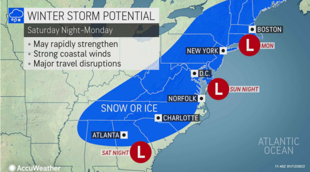
The storm will then make its way south, moving as far as southeast Oklahoma and Arkansas before pivoting towards Tennessee, Porter said. Portions of Arkansas, Missouri, Tennessee, South Carolina, North Carolina and Georgia are under winter storm watches over the weekend.
With the incoming storm system, Nashville could end up with more accumulated snow so far this winter season than both Milwaukee and Chicago. "That's pretty impressive," Porter said.
Meanwhile, Atlanta, which hasn't seen snow in the last four years, could potentially be impacted by the winter storm beginning Saturday and Sunday, Porter said. But the NWS said it was too early to tell how much and what kind of precipitation the area might see.
"What we know in the Atlanta area is that even a little bit of snow or ice can cause a big impact," he said. "There's less plows, people are less experienced at dealing with and driving in snow in those areas. So we've been raising the alarm bells about Atlanta."
He also warned that ice could coat the Ohio and Tennessee valleys into western Virginia and stay for many hours.
"We're going to be talking about a very significant ice storm," Porter said. "Cold air right near the ground, locked in across parts of the Carolinas. The interior parts of the Carolinas is a recipe for rain to freeze on contact on cold surfaces."
Significant tree damage with possible widespread power outages are possible in icy areas, he said.
Then, the storm is forecast to lash the Northeast with intense cold winds. Porter said snow and cold rain is possible for major cities like New York City, Philadelphia, Baltimore and Washington, D.C., Saturday night through Monday.
The winter storm comes at a time when some areas need the precipitation. According to meteorologist Stephanie Abrams of the Weather Channel, Des Moines is 8.6 inches below its average snowfall.
"We are going to potentially wipe out our entire deficit with this one system," Abrams told CBS News.
But other places, including Washington, D.C., Virginia and Maryland, are in for yet another storm just one week after the last winter system. Porter says these states in particular have been in an active storm track this winter, as they line the boundary between much cooler air from the North.
"It's a recipe for storms when you have those kinds of differences in the air masses," he said.
Porter recommends anyone in the winter storm's path to get ready for it now by rearranging travel plans and making sure critical items like food and prescriptions are ready in the case of power outages.
"Small changes in the track of the storm can have big impacts to just how much snow or icefall in various areas, so it's a good idea to keep up to date with our updated forecasts," he said. "It's going to be very important to prepare."

