Sandy power outages spotted from space
When Sandy's punishing winds and waves smacked into New Jersey and New York Oct. 29, they knocked out power to millions.
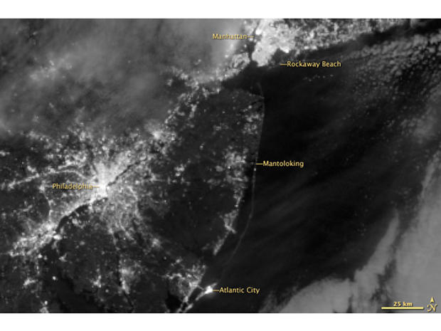
In the immediate aftermath of Hurricane Sandy, more than 8 million people were thought to be without power. Some 90 percent of Long Island lost power, as well as numerous communities in New Jersey and all of Lower Manhattan ?which created strange views of the island's iconic skyline from neighboring boroughs and New Jersey.
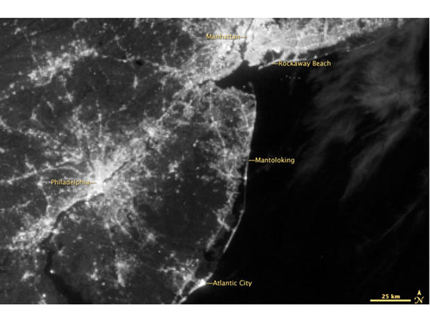
The Suomi NPP satellite caught the eerie sight from above at 2:52 a.m. EDT this morning (Nov. 1). It stands in contrast to an image taken of the same area -- New Jersey, New York and eastern Pennsylvania -- Aug. 31.
The image was taken with the "day-night band" on the satellite's Visible Infrared Imaging Radiometer Suite (VIIRS). This band detects light between the green and near-infrared wavelengths of light, according to NASA's Earth Observatory. Filtering brings out features on the Earth's surface like gas flares and city lights -- or, in this case, lack of lights.
A close look at the images reveals the dark lower end of Manhattan. Long Island and New Jersey appear dimmer in the Nov. 1 image than in the Aug. 31 one.
"The barrier islands along the New Jersey coast, which are heavily developed with tourist businesses and year-round residents, are just barely visible in moonlight after the blackout," the Earth Observatory notes.
Con Edison has said that power should be restored to Lower Manhattan by Saturday. Restoring power to other locations could take longer.
Follow OurAmazingPlanet for the latest in Earth science and exploration news on Twitter @OAPlanet. We're also on Facebook & Google+.
- 'Frankenstorm' from Space: Hurricane Sandy Satellite Photos
- A History of Destruction: 8 Great Hurricanes
- On the Ground: Hurricane Sandy in Images
Copyright 2012 OurAmazingPlanet, a TechMediaNetwork company. All rights reserved. This material may not be published, broadcast, rewritten or redistributed.

