What is the polar vortex and is global warming to blame?
Forecasters say millions of people in the Midwest and Great Lakes will see record-shattering wind chills from 40 to 65 degrees below zero this week — cold so extreme it could cause frostbite on exposed skin in five minutes or less. Some 100 million people will experience temperatures near or below zero. Here's what you need to know about the polar vortex behind the deep freeze.
What is the polar vortex?
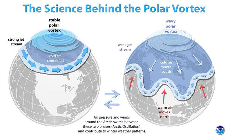
The frigid air will come from a brief visit by the polar vortex — which is a real meteorological phenomenon, not just a sensational headline. It's a whirling mass of cold air circulating in the mid- to upper-levels of the atmosphere, present every winter.
It usually stays closer to the poles but sometimes breaks apart, sending chunks of Arctic air southward into the U.S. during winter.
This week's particularly cold outbreak may be explained by the relative lack of cold air so far this winter in the eastern U.S. Instead of the cold air bleeding south a little at a time, it's coming all at once.
How cold will it get?
The polar vortex will result in some shockingly cold temperatures this week. The National Weather Service in Chicago forecasts it will be the coldest Arctic outbreak in 25 years and perhaps since records have been kept.
Wednesday's high temperature in Chicago is forecast to be 12 below zero. Low temperatures from 5 to 15 below zero are likely in Indianapolis, Detroit, Cleveland, Buffalo, Albany and Burlington with wind chills as low as 40 below Thursday morning.
The worst impacts will spread from the Upper Midwest Tuesday, through the Great Lakes Wednesday and into the Northeast by Thursday.
If there's any saving grace to this current bitter blast, it's that the mass of cold air won't penetrate very far south, with the core staying over the northern third of the nation. Temperatures in central and South Florida will stay above 40 degrees.
How long will the cold last?
The cold blast won't last very long. The coldest air will be in retreat by Friday. By Sunday temperatures will back in the 50s in parts of the Ohio Valley — feeling like 100 degrees warmer than this week's lowest wind chills.
Is the polar vortex connected to climate change?
A counterintuitive theory about the polar vortex is gaining ground among some in the climate science community: Regional cold air outbreaks may be getting an "assist" from global warming. While it may not seem to make sense at first glance, scientifically it's consistent with the extremes expected from climate change.
Overall, Earth is warming due to climate change, but areas near the North Pole are warming more than 2 times faster than the rest of the globe. This "Arctic Amplification" is especially pronounced in winter.
When warm air invades the Arctic Circle, it weakens the polar vortex, displacing cold air masses southward into Europe, Asia and the United States. You might think of it as a once tight-knit circulation unraveling, slinging pieces of cold air outward.
Evidence for this was presented in a research paper published in the Journal of the American Meteorological Society. Essentially, it suggests climate change can contribute to a more extreme, wavy jet stream, hurling cold air masses farther south.
It should be noted that this theory is relatively new and there is a lot of debate in the climate science community about the extent to which such a connection exists. CBS News reached out to two leading climate scientists for comment about whether or not a portion of the recent Arctic outbreaks can be traced to climate change. Here's what they had to say:
Dr. Judah Cohen, a climate scientist at Atmospheric and Environmental Research (AER), told us:
I have argued that low sea ice and extensive snow cover [in autumn] as a result of Arctic amplification have resulted in more frequent weakenings or disruptions of the polar vortex in recent decades.
When the polar vortex is weak or "perturbed," the flow of air is weaker and meanders north and south (rather than west to east). This allows a redistribution of air masses where cold air from the Arctic spills into the mid-latitudes and warm air from the subtropics is carried into the Arctic.
Dr. Michael Mann, the director of the Earth System Science Center at Pennsylvania State University, said:
These questions test the limits of both our available data (the apparent increase in frequency of these events is quite recent and so at best only just starting to emerge from the background noise) and the model simulations.
As we showed in our recent Science article, current generation climate models don't resolve some of the key processes involved in the jet stream dynamics behind many types of weather extremes.
Honest scientists can legitimately differ based on reasonable interpretations of the evidence to date.
In summary, most scientists involved with this kind of research are intrigued by the theory. It is a very active area of research. Generally, they agree that more study and improved climate models are needed to zero in on the causes and effects.
