How much snow did you get? Maps show total inches of snowfall accumulation from winter storm
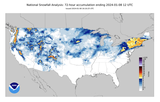
Two weather systems hit the United States over the weekend, bringing snow, rain and heavy wind to vast stretches of the country, particularly the Northeast and parts of the West and Midwest. Maps illustrating the total snowfall accumulation from coast to coast after the weekend's winter storms show just how much, or how little, fell in different parts of the country, as a number of states brace for more winter weather still ahead over the next few days.
Snowfall totals for major cities so far
Philadelphia and New York City were primarily hit with rain during the weekend's storm, with just a dusting of snow seen at Philadelphia International Airport and around one-fifth of an inch recorded in Central Park as of Sunday night. Between 1 and 3 inches fell in Boston.
Areas surrounding all three cities were blanketed with heavy snow — as much as a foot of it — especially in the Poconos in Pennsylvania, the Hudson Valley in New York, and counties just north of Boston extending into southern New Hampshire.
A second storm system traveling eastward from the West Coast dumped snow on sections of Arizona, Colorado, Idaho, Nevada, New Mexico and Utah over the last few days and continued on Monday.
Parts of Salt Lake City saw between 3 and 6 inches of snow, while snowfall totals recorded just outside the metropolitan area were much higher, with some places getting as much as 15 or 17 inches over the last three days, according to National Weather Service. Denver ecorded between 1 to 4 inches of snow in various parts of the city by Monday, with meteorologists forecasting more winter weather still to come.
Snow also fell over the Midwest on Monday, with about 1 1/2 inches already recorded in Lincoln, Nebraska, early in the morning. Up to 2 inches of snow accumulated in areas of Chicago over the last few days, and up to 6 inches was expected moving further into the week, CBS Chicago reported. Snowfall totals in Minneapolis were under an inch as of Monday, although accumulation was much higher in surrounding areas. Detroit was expecting to see its first big snowfall of the year on Tuesday.
How much snow has the U.S. gotten so far?
Between Friday and Monday, accumulation was most significant outside of major cities and in areas of higher elevation, and heavy snow was more widespread in northern states. In the Northeast, parts of Maine, Massachusetts and upstate New York saw as much as 18 inches of snow tied to the winter storm. Totals of over a foot were also reported in parts of New Hampshire, Vermont, Connecticut, Pennsylvania and New Jersey.
Across the West and Midwest, meteorologists reported pockets of heavy snow between 8 and 18 inches, but lighter accumulation — between 1 and 4 inches, or 6 inches in some areas — was more common.
Who got the most snow from the weekend storm?
Groton, Vermont, a town some 20 miles from Montpelier, recorded the highest snowfall total of the last three days in the U.S., with over 22 1/2 inches, according to a National Weather Service map that uses data compiled from local agencies. Wolf Creek Pass, a high mountain pass in southwestern Colorado, recorded the second-highest total, 21 inches.
Earlier, the weather service shared the highest Northeast snowfall totals by state Sunday night. They were: 18 1/5 inches in Tyngsboro, Massachusetts; 18 inches in East Wakefield, Maine; 18 inches in Milton, New York; 17 inches in Salem, New Hampshire; 17 inches in North Granby, Connecticut; 16 inches in West Barnet, Vermont; 15 inches in Albrightsville, Pennsylvania, 13 1/2 inches in Wantage, New Jersey; and 11 inches in Glocester, Rhode Island.
Who is forecast to get more snow?
The second major winter storm barreling through the U.S. this week is expected to bring several feet of snow to parts of Washington state and Oregon though Tuesday, the weather service said in a bulletin, while a mid-latitude cyclone forms over the central and southern Great Plains. A mid-latitude cyclone is a low pressure system that in the continental U.S. can create a range of weather conditions, including including heavy snow, sleet, rain and coastal flooding, according to the National Oceanic and Atmospheric Administration.
Meteorologists forecasted snowfall over the Great Plains area Monday that would advance toward the Midwest later in the night and into Tuesday. "Bursts of heavy snow may accumulate up to two inches in an hour, and result in hazardous travel," the weather service warned.
Snow and wind gusts as high as 60 or 70 miles per hour could create "ferocious blizzard conditions with whiteouts" that will make travel "extremely dangerous to impossible" in parts of northeastern New Mexico, eastern Colorado, the Oklahoma and Texas panhandles, western Kansas and southwestern Nebraska.
"If you must travel, pack a winter survival kit as wind chills will plummet below zero," the weather service said. Heavy snow was also forecast for the Cascades and Rocky Mountain areas.
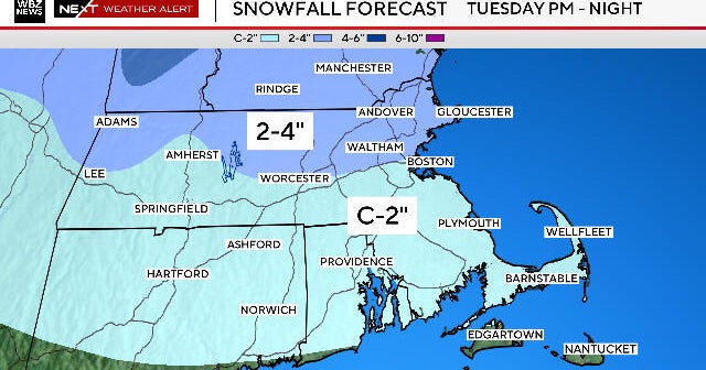
Inland areas in the Northeast were also expected to see another round of "heavy, wet snow" on Tuesday afternoon and into the night, according to the weather service.
Severe thunderstorm threat from Gulf Coast to Southeast
Farther south, the weather service warned of an "enhanced risk of severe thunderstorms" with strong wind gusts and tornadoes possible across the central Gulf Coast Monday night into early Tuesday morning, shifting into parts of southeastern Alabama, northern Florida and parts of the Carolina Piedmont/Coastal Plain on Tuesday.
"Very strong and damaging winds as well as a few tornadoes will be the main threats," it warned.


