Imelda's immense rain is now 7 times more likely than just 30 years ago
Over 36 inches of rain fell in just 36 hours in parts of coastal Texas this week. Astronomical rain rates of 6 inches per hour were observed generating the equivalent of a month's worth of rain in 60 minutes.
Imelda's immense rainfall is both amazing and also desensitizing – very rare, historic rainfall has now fallen along the western Gulf Coast a few times in as many years. It's becoming a lot more common because of climate change.
According to the National Weather Service in Lake Charles, Louisiana, "this event is unofficially the fifth wettest tropical cyclone in the continental U.S. history."
Noted MIT Atmospheric Science Professor Dr. Kerry Emanuel analyzed the likelihood of historic rain events like Hurricane Harvey in Texas following the 2017 storm. He called Harvey's rainfall in Houston "biblical" in that it is only likely to occur once since the Old Testament was written.
Using a very low-end estimate of 20 inches for Harvey's rainfall in the city of Houston, Emanuel found that "the probability of rainfall larger than this magnitude is around once in 2,000 years" in the climate of the 1980s and 1990s.
But given the recent rapid changes in climate due to heat trapping greenhouse gases, the probability of event like Harvey happening in 2017 increased markedly to 1 in 325 years.
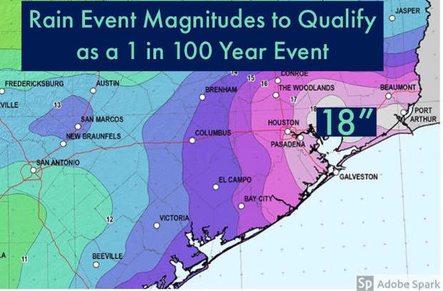
CBS News reached out to Emanuel about the probability of an event the magnitude of Imelda occurring along the Texas East Coast. Emanuel estimates "that for the region affected, this would have been about a once in 700-year event in the late 20th century but has increased to about a 1 in 100-year event today."
What that translates to is a 7-fold increase in the likelihood of an event like Imelda happening in just a few decades.
The science on this is rather simple: The atmosphere has warmed around 2 degrees Fahrenheit since the 1800s. For every 2 degrees of temperature rise, the atmosphere holds 8% more moisture and thus squeezes out more heavy rain.
This effect is heightened by warmer Gulf of Mexico waters which act to bolster rising air and thunderstorms, moisture convergence and rainfall rates. That boosts total rainfall even more.
The last point is the slow movement of storms like Harvey and Imelda. While storms sometimes travel slowly and stall for natural reasons, a 2018 study by National Oceanic and Atmospheric Administration (NOAA) scientist James Kossin shows that the forward motion, especially of tropical systems making landfall, has slowed by 16% in the Atlantic basin. As for the reasoning, Kossin cites evidence linking global warming to the weakening of the summertime tropical circulation.
Adding those climate change effects into the equation, the result is more extreme events like Imelda. And as long as the climate continues to warm, storms will continue to produce more torrential rains and life-threatening flooding.
While the international community hopes to keep warming well below 3.6 degrees Fahrenheit, given our slow progress at reigning in greenhouse gases, most climate scientists project we are likely headed for 6 degrees Fahrenheit of global warming.
In a scenario like this, the likelihood of historic rain events like Imelda and Harvey will increase significantly.
Mapping 20-inch rain events in Houston from 1980 to 2000, the return period was once per 2,000 years. That number is now once in 325 years. By 2100, the chance is estimated to be 1 in 100 years.
Because of a much warmer Earth, the chance of a historic rain event in the city of Houston will have increased by 20 times in 100 years' time.
