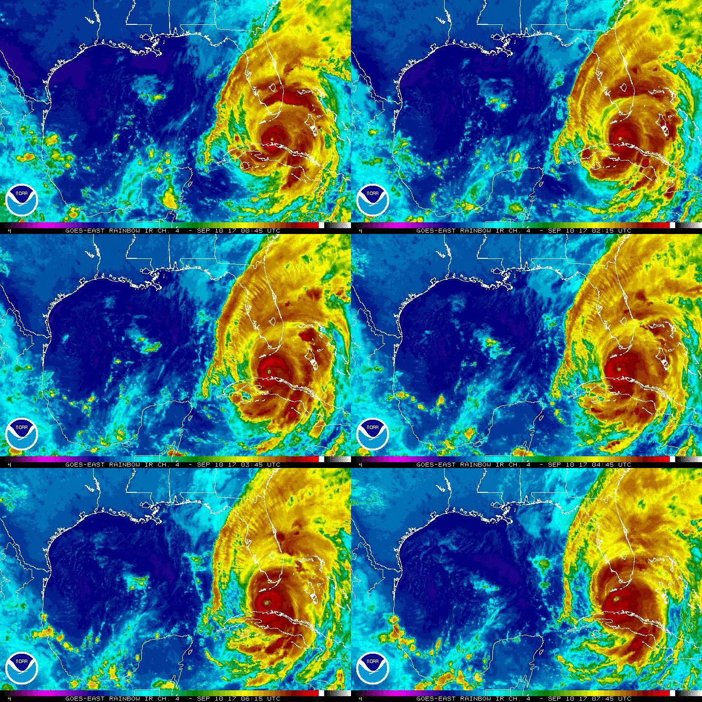
Hurricane Irma makes landfall in lower Florida Keys
Hurricane Irma began its assault on Florida early Sunday and made landfall on Cudjoe Key in lower Florida Keys with top sustained winds of 130 mph.
As a powerful Category 4 storm, Irma lashed the area. The U.S. National Hurricane Center said it was expected to remain a powerful storm as it moved through the Florida Keys and near the state's west coast.
Irma regained strength as its eyewall reached the lower Florida Keys early Sunday and forecasters monitored a crucial shift in its trajectory -- just a few more miles to the west -- that could keep its ferocious eye off the southwest Florida coast and over warm Gulf water.
The eyewall is a band of clouds surrounding the center of the storm that has intense winds and strong rain.
The storm left at least 27 people dead across the Caribbean.
"Life threatening storm surge is occurring now in the Keys and is expected to begin this morning in Southwest Florida," Florida Governor Rick Scott warned in an early morning tweet.
Hurricane warnings were in effect for Fernandina Beach southward around the Florida peninsula to Indian Pass, all of the Florida Keys, Lake Okeechobee and Florida Bay.
Follow along below for live updates on the storm. All times are Eastern unless otherwise noted.
9:30 a.m.: Irma makes landfall
Hurricane Irma has made landfall on Cudjoe Key in the lower Florida Keys. The U.S. National Hurricane Center in Miami said the storm's center made landfall at 9:10 a.m. Its top sustained winds are 130 mph.
8:15 a.m.: Hurricane Irma's center poised to blow across Florida Keys, forecasters say
The U.S. National Hurricane Center said in a public advisory that the center of the storm remained offshore but was going to make landfall soon. The storm was centered about 20 miles east of Key West, and it was moving north-northwest at 8 mph.
The storm had maximum sustained winds of 130 mph. The National Weather Service reported wind gusts of 90 mph near its Key West office. After hitting the Florida Keys, Irma was forecast to move up the state's Gulf Coast later Sunday.
8:05 a.m.: Tornado warnings issued
The National Weather Service in Miami has issued tornado warnings for a wide swath of Monroe, Miami-Dade and Broward counties in South Florida.
Officials say the band of rain and tornado producing cells is moving quickly. There have been no reports of tornadoes touching down.
Authorities are urging people to stay inside until the storm passes.
"Due to extreme sustained winds rescue teams are no longer able to respond. Stay inside and Stay safe until the storm has passed," the City of Miami Beach tweeted.
In a Facebook post early Sunday, Key West Police urged people who stayed for the hurricane to remain where they took shelter until the storm had passed completely. They also urged people not to go outside when the eye of the storm is over there area, a time period when conditions can seem deceptively calm.
6:55 a.m.: St. Petersburg now in Irma's crosshairs
With Hurricane Irma churning toward the Florida Key's and the southernmost tip of the mainland on Sunday morning, Florida Power & Light said more than 250,000 homes and businesses were already without power by 6:30 a.m. in Miami-Dade county -- an hour before the storm was even expected to make landfall. Another 97,370 outages were reported in Broward.
The outages were blamed largely on high winds snapping power lines and taking out transformers.
12:40 a.m., Sept. 10: St. Petersburg now in Irma's crosshairs
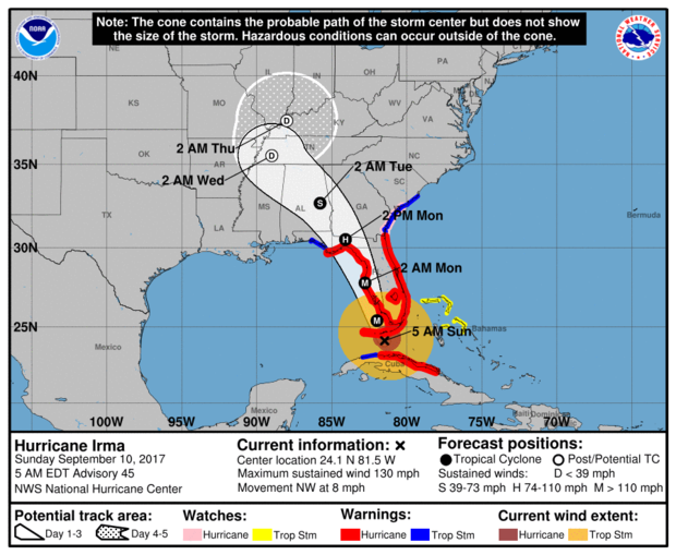
The National Hurricane Center's latest tweak to Irma's forecasted track has the storm hugging the Florida's west coast off Fort Myers, but possibly not making landfall there before moving back to the Gulf of Mexico. By moving the likely track a few crucial miles west, the storm would be able to regain strength over water before its deadliest winds hit St. Petersburg and Clearwater, rather than the more populated Tampa.
After that, the storm is now expected to skirt the coast again a bit north of Horseshoe Beach, then finally go inland around Fish Creek, northwest of Ocala, with a hurricane-force wind field well over 100 miles wide.
Irma's forward motion slowed to 6 mph as the storm stuttered off the coast of Cuba. Forecasters say it could still increase in strength, but their forecast didn't show it.
11:55 p.m.: South Florida county pulls deputies off roads
The Broward County sheriff's office tweeted late Saturday that with wind gusts measuring 45 mph, they are pulling deputies off the road until conditions are safer.
Fort Lauderdale is located in Broward County.
11 p.m.: Irma is taking its time leaving Cuba
Hurricane Irma is moving slowly away from the north coast of Cuba as hurricane-force winds were recorded in the Florida Keys, the National Hurricane Center said.
A turn toward the north-northwest with an increase in forward speed is expected through late Monday. The center of Irma is expected to pass through the Keys Sunday morning and then move near or along the west coast of Florida Sunday afternoon through Monday morning. Irma should then move inland over the Florida panhandle and southwestern Georgia Monday afternoon.
Dangerous storm surges are expected in Florida, with surges of 10 to 15 feet from Cape Sable to Captiva.
More than 170,000 homes and businesses in Florida are without power, Florida Power and Light said. More than half the outages are in the Miami-Dade area.
9:30 p.m.: Near hurricane-force wind gusts recorded in Florida Keys
A National Ocean Service station in Vaca Key recently reported sustained winds of 48 mph with a gust to 66 mph, the National Hurricane Center said. Marathon Key recently reported sustained winds of 51 mph with a gust to 71 mph.
As of 9 p.m., Irma was located 105 miles southeast of Key West, the National Hurricane Center said.
9:20 p.m.: Some Naples residents will wait out Irma
As Hurricane Irma moves in on Florida's West Coast, residents who initially thought the coast was clear scrambled to escape.
Naples residents Al and Carol Rodriguez tried but failed to book a flight to higher ground.
Reluctantly they will ride out the storm in their home.
Art Neumann - who lives just five blocks from the Gulf -- says hes staying in defiance of Irma. Even though the longer we spoke, the more concerned he sounded.
The fear is not so much the damaging winds but the drowning storm surge -- a wave of water expected to be between 6 and 12 feet high, a killer for a region thats only 3 feet above sea level.
Further north in Fort Myers, businesses were taking no chances.
"We're preparing a lot better i think. A lot of people have really been serious about this one. They are taking precautions a lot sooner," said Patrick Cavanaugh, another holdout. "The word catastrophic gets your attention."
8:40 p.m.: Florida opens up shelters for those who ride out the storm
The Sunshine State is taking its first blows from the monster storm, CBS News' Elaine Quijano reports from the Florida Keys.
In the Keys, the islands could be swamped, including half of the island of Key West. The storm surge could be as much as 10 feet -- and anything above 3 feet is considered life-threatening.
"It's time to punch out -- and we need to get out of here," said one resident.
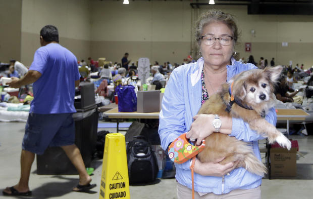
County officials opened up 4 refuge sites in the Keys for those who choose to wait out the storm. Across the state, at least 330 shelters are open. Eleven of the 42 in Miami-Dade County are at capacity, including those that are pet-friendly.
7:45 p.m.: Irma spins up funnel clouds, tornado in Florida
Hurricane Irma is starting to spin up funnel clouds and at least one tornado, leading to warnings for parts of South Florida.
The National Weather Service in Miami posted on Twitter Saturday evening that a tornado had touched the ground in the Fort Lauderdale suburb of Oakland Park. It wasn't immediately clear if it resulted in any damage.
Tornado warnings have been issued for Fort Lauderdale, Coral Springs, Pompano Beach and Sunrise in Broward County, as well as parts of nearby Palm Beach and Hendry Counties.
6:52 p.m.: 76,000 Florida residents without power
Florida Gov. Rick Scott said in a news conference Saturday that 76,000 people were without power as Hurricane Irma unleashed winds and rain on the state. He said that outages are expected to grow as the storm approaches Florida.
He warned people that the storm is life-threatening and told residents that have been ordered to evacuate that now is the time to go. He says this is the last chance they will have to make a good decision.
6:44 p.m.: Zoos and shelters race to get animals to safety
As bands of Irma started making their arrival at Zoo Miami early Saturday morning, Diesel was led from his rain-soaked cage, walked a few feet into a nearby reinforced building and settled in next to another cheetah in their new temporary home with a hay-covered floor. Until Irma passes, that's where they'll stay.
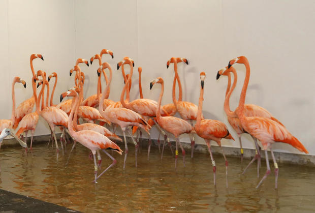
Such was the sentiment around Florida on Saturday, where zoos, theme parks, rescue centers and other places with animals were bracing for Hurricane Irma's arrival. Five dolphins were moved from the Florida Keys to Central Florida in advance of the storm, but most zoos and the like in the Miami area said they were trying to keep their animals in place and secure from whatever Irma will bring.
Hundreds of thoroughbreds were moved from low-lying areas of Gulfstream Park, near Miami, to other training facilities and barns farther north. Some animal shelters were relocating dogs and cats to safer facilities, and a humane society near Tampa said it needed temporary foster homes for more than 100 dogs -- a necessary move since Irma's track was headed west toward the Gulf side of the peninsula Saturday.
"We live in a hurricane-prone area so our facilities are designed to accommodate these storms," said Brian Dowling, the general curator at Lion Country Safari in Palm Beach County -- a facility with lions, chimpanzees, rhinos and more, all of whom stayed put for the storm. "Obviously, everything can't be hurricane-proof."
6:13 p.m.: Number of evacuees in shelters climbs to 75,000
More than 75,000 people have flocked to shelters in Florida to escape Irma's potentially deadly winds and storm surge.
The state said Saturday that more than 400 shelters are open, mostly in schools, churches and community centers.
A hectic scene happened outside a minor league hockey arena in southwest Florida, where thousands of people were stuck in line. Some waited for more than five hours to get inside because only two doors were open.
When rain began falling heavily, more doors were open and the 8,400 seat Germain Arena quickly filled.
More than 6 million people have been warned to evacuate.
5:53 p.m.: Toxic waste sites in likely storm path
Hurricane Irma bore down on Florida while dozens of personnel from the Environmental Protection Agency worked to secure some of the nation's most contaminated toxic waste sites. The agency said its employees evacuated personnel, secured equipment and safeguarded hazardous materials in anticipation of storm surges and heavy rains.
The Associated Press surveyed six of the 54 Superfund sites in Florida before Irma's arrival, all around Miami in low-lying, flood-prone areas. There was no apparent work going on at the sites AP visited this past week.
The EPA said that if there was no activity, a site should be considered secured but would be closely monitored. The sites were in various stages of federally directed, long-term cleanup efforts.
Read the full story here.
5:44 p.m.: Trump holds Cabinet meeting at Camp David
President Trump met with Vice President Mike Pence and his cabinet at Camp David in Maryland Saturday afternoon, discussing the projected path of Irma. The meeting was closed to the press, although the White House released three images from the 2 p.m. meeting. The White House did not say what other topics the meeting touched upon, although an earlier statement from a White House official said the cabinet would also discuss administration priorities in addition to Irma and continued fallout from Hurricane Harvey.
So far, Mr. Trump has spent three weekends at Camp David since taking office, according to CBS News White House correspondent Mark Knoller.
5:05 p.m.: Irma's eye begins to move away from Cuba
Weather is deteriorating in South Florida as Irma's center continues to slowly drift away from Cuba and move toward the Florida Keys. As of 5 p.m., the National Hurricane Center says the system is moving west-northwest at 9 mph, with the center located 115 miles south of Key West.
The center says "major hurricane force winds" will arrive in the Keys by Sunday morning.
4:22 p.m.: Thousands stuck in lines outside shelters
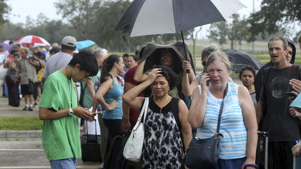
With Hurricane Irma taking aim at Florida's southwestern coast, thousands of desperate and frustrated people waited in line for hours Saturday to get inside a shelter -- a minor league hockey arena -- in hopes of avoiding the storm's wrath.
Dogs barked and children cried in a line that wrapped halfway around the 8,400-seat Germain Arena before snaking through the parking lot. Ambulance sirens drowned out the chatter as medics assisted people overcome by the 84-degree heat.
More than 50,000 people statewide sought refuge at over 400 shelters, mostly schools, community centers and churches, but few if any scenes matched what happened just outside the city of Naples.
Read the full story here.
3:42 p.m.: Video shows waves in Key West
The U.S. Navy posted this video of waves crashing on shore in Key West:
3:22 p.m.: Correspondent David Begnaud heading to Tampa as Irma looms
CBS News correspondent David Begnaud was 10 miles east of Tampa on Florida's I-4 corridor Saturday afternoon, traveling to the city now in the path of Irma. Vehicles packed with belongings were bumper-to-bumper and driving 20 to 25 mph as they evacuated the city, headed toward Miami. Members of the National Guard used the shoulder of the highway to pass through the long lines of traffic on Saturday.
Gov. Rick Scott is urging residents on the eastern part of the state not to return home even if they think their home is in the clear. The storm's path could shift within the next 12 hours, though it looks like the western part of the state will bear the brunt of the hurricane.
Begnaud says every rest stop along the evacuation route on I-95 and the Florida Turnpike had groceries and fuel.
You can follow Begnaud on Twitter as he rides out the storm in Tampa at @DavidBegnaud.
2:52 p.m.: Collier County officials give an update on preparations for Irma
Officials from Collier County, which includes Naples, are briefing reporters with the latest developments. Watch live in the player at the top of this article.
2:02 p.m.: Irma continues to linger over Cuba
The National Hurricane Center says Irma's wind speed remains at 125 mph as of 2 p.m. It's continuing to move along the Cuban coast at 9 mph, and is now about 145 miles southeast of Key West.
1:21 p.m.: Irma shifts course, heading toward Tampa and Naples
Irma is on a shifting course that is turning it away from Miami and instead threatening the first direct hit on the Tampa area from a major hurricane in nearly a century.
That represented a significant turn in the forecast, which for days had made it look as if the Miami metropolitan area of 6 million people was going to get slammed head-on by the Big One.
Forecasters predicted Irma's center would blow ashore Sunday in the perilously low-lying Florida Keys, then hit southwestern Florida, move up the state's Gulf Coast and plow into the Tampa Bay area.
The storm center itself is expected to miss Miami, but the metro area will still get pounded with life-threatening hurricane winds, National Hurricane Center spokesman Dennis Feltgen said.
Read the full story here.
12:38 p.m.: Florida governor: Irma "the most catastrophic storm the state has ever seen"
Florida's governor is issuing urgent warnings to a third of his state's residents to evacuate ahead of a massive hurricane on track to be the state's most catastrophic ever.
Gov. Rick Scott says the entire west coast of Florida will likely see dangerous affects from storm surge as Hurricane Irma comes ashore Sunday. About 6.3 million of the state's approximately 21 million residents have been asked to evacuate.
During a Saturday news conference, he told those in evacuation zones: "You need to leave -- not tonight, not in an hour, right now."
Scott said that the storm surge is expected to be up to 15 feet in some areas along the west coast of Florida. In the Tampa Bay area, Scott said the storm surge could be between 5 feet and 8 feet.
Scott said: "This is the most catastrophic storm the state has ever seen."
12:26 p.m.: Possible tornado moving towards Everglades City, National Weather Service says
12:18 p.m.: Thousands without power in South Florida
There have been more than 30,000 power outages in Miami-Dade County and 1,870 in Broward County, according to the Florida Power & Light Company (FPL).
More than 3 million customers could be affected by power outages during Hurricane Irma.
FPL spokeswoman Florencia Contesse told CBS Miami the company is ready for whatever Hurricane Irma may bring. She said they specifically train for situations like this and have prepared crews and equipment.
"We've set up more than 20 staging sites across the state. These essentially serve as mini-cities where we have our workers, our equipment, our trucks, so we can quickly get out into the community and restore service," Contesse told the station.
12:11 p.m.: Florida asks 700,000 more people to evacuate, bringing total to 6.3 million
Florida emergency management officials have asked another 700,000 to evacuate ahead of Hurricane Irma. That brings the total number asked to evacuate multiple states to nearly 7 million.
Florida Gov. Rick Scott said Saturday that officials have issued a mix of mandatory and voluntary evacuation orders to 6.3 million residents. The number rose overnight as the predicted path of Hurricane Irma has shifted west. It's likely to come ashore Sunday.
The size and trajectory of the storm has prompted officials to order evacuations along both coasts of Florida, including some of the state's population centers. Florida is the nation's third largest state with nearly 21 million residents.
Another 540,000 have been asked to evacuate in the eastern part of Georgia.
In South Carolina, a mandatory evacuation order was issued for eight barrier islands. That includes Hilton Head Island, the most populous of the islands with about 40,000 residents.
11:51 a.m.: The eye of the storm, as seen from a plane
Capt. Phil Blancher from the Air Force Reserve's hurricane hunters captured this view of Irma's eye while flying into the storm on Friday:
11:22 a.m.: South Florida cities impose curfews
Local governments are now issuing curfews across South Florida, CBS Miami reports.
Broward County has issued a curfew starting at 4:00 pm and remains in effect until further notice.
"When winds reach 45 mph, deputies will not be responding," Broward County Mayor Barbara Sharief said. Effects of the storm will get stronger throughout the day. "By 2 p.m., residents will start feeling tropical storm force winds."
A mandatory curfew will also be in place tonight in Coral Springs from 8 p.m. to 6 a.m. A barrier island curfew will be in effect for the city of Deerfield Beach and the town of Hillsboro Beach at noon. A citywide curfew will be announced later this afternoon.
Check CBS Miami for the latest curfews.
11:12 a.m.: At least 51,000 people move to shelters in Florida
Florida emergency management officials say at least 51,000 residents have hunkered down in approximately 300 shelters ahead of Hurricane Irma.
Most of those staying in shelters are in southeast Florida, which initially looked to be the main target of the storm before the forecast shifted west. More than 15,000 people are in shelters in Palm Beach County while neighboring Broward County has nearly 13,000 people.
The threat of Irma has prompted state and local officials to ask 5.6 million residents to flee ahead of the storm. It's expected to come ashore Sunday and take aim at the Tampa Bay area.
Officials in the Florida Keys are evacuating some 460 inmates and 125 corrections officers from a jail on Stock Island to a jail in Palm Beach County.
Spokeswoman Becky Herrin said in a news release that Sheriff Rick Ramsey made the decision Friday night because of the changing path of Hurricane Irma. The jail on Stock Island is near Key West on the lower end on the island chain.
11:03 a.m.: Irma downgraded to Category 3, but expected to strengthen
The National Hurricane Center's 11 a.m. advisory shows Irma plodding along the coast of Cuba, with wind speeds decreasing to Category 3 levels of 125 mph. But the storm is expected to restrengthen once it moves off Cuba and heads north toward the Florida Keys.
Its center is now located about 175 miles southeast of Key West and moving at 9 mph.
10:34 a.m.: St. Martin and St. Barts face another hurricane
Residents in the French overseas territories of St. Martin and St. Barts have another hurricane at their doorstep after a devastating blow from Irma.
Hurricane Jose was closing in Saturday. Forecasters expected winds of up to 93 mph, along with torrential rains and large waves.
French authorities said Saturday that some 1,105 workers are now deployed St. Martin and St. Barts to help the islands' recovery. By Saturday, damage estimates from Irma reached the 1.2 billion euro mark -- pockmarking the islands that have become famous as lush playgrounds for the rich and famous.
In St. Martin, travel to or from the island has ground to a halt until Jose passes.
Jacques Witkowski is France's Director of Public Safety. He says the international airport isn't operational.
The last airplane flew in to the battered Grande-Case de Saint Martin airport Friday. It carried emergency workers to help with reconstruction as well as specialists who aim to re-establish the island's damaged water and electricity systems.
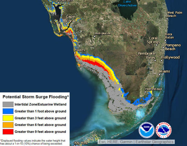
10:24 a.m.: Map shows expected level of storm surge
The biggest danger to life and property from Hurricane Irma could come from storm surge that forces seawater inland, which could topple houses, isolate residents who don't evacuate and make drowning an imminent threat, the National Hurricane Center is warning.
Storm surge occurs when heavy winds push the ocean onto the land, and it's a destructive feature of many cyclones and hurricanes, including Hurricane Harvey in Texas last month. Irma's surge could top 12 feet in areas of the Florida coast, and some surge is predicted up and down the state's Atlantic and Gulf coasts.
The National Hurricane Center has an interactive map on its website showing the expected level of storm surge in South Florida. As of 5 a.m. Saturday, some of the highest totals are expected along the southwest coast east of Naples:
9:50 a.m.: Florida governor: Window to evacuate is closing fast
Florida Gov. Rick Scott urged residents who have been asked to evacuate and have not yet evacuated to get out while they still can, calling Irma unlike anything Florida has ever seen before.
Scott said public safety officials will be unable to reach people in need once the storm hits the mainland within hours.
"This is a deadly storm, and our state has never seen anything like it," Scott said.
Storm surges, up to 12 feet in some areas, "will cover your house," he added.
"You will not survive all this storm surge," Scott said. "This is a life-threatening situation."
9:35 a.m.: Tornado warning in Miami-Dade County
The National Weather Service in Miami has issued a tornado warning for an area including Miami-Dade County until 10:15 a.m.:
9:30 a.m.: Florida governor gives update on Irma
Florida Gov. Rick Scott is scheduled to hold a press conference on the state's preparations for Irma shortly. Watch live in the player at the top of this article.
