Hurricane Hanna makes landfall in South Texas
Hurricane Hanna officially made landfall Saturday just south of Corpus Crisiti, Texas, on Padre Island at 6 p.m. ET with maximum sustained winds of 90 mph. Hanna has potential for damaging winds and severe flooding. Hanna made landfall 6 mph short of being labeled a Category 2 storm, according to the Texas Division of Emergency Management.
Hanna made a second landfall at 7:15 p.m. ET in Kennedy County, Texas, again with maximum sustained winds of 90 mph, according to the National Hurricane Center.
Texas Governor Greg Abbott issued a State Disaster Declaration for 32 counties as the storm made its first landfall.
Hanna was upgraded from a tropical storm to a hurricane while it still churned off the coast of Texas on Saturday, becoming the first hurricane of the 2020 Atlantic hurricane season, according to the National Hurricane Center.
Most of the commercial flights scheduled to fly into Corpus Christi International Airport on Saturday had been canceled due to the impending storm. Flights schedules to depart or arrive on Sunday were still on as of Saturday evening, although the city noted that could change depending on the severity of the storm.
The 2020 Atlantic season is likely to be one of the most active in recorded history because of abnormally warm water and other climate conditions. Hanna is already the eighth named system of the young 2020 season in the Atlantic so far, putting it ahead of a record pace set in 2005 by 10 days.
Near-historic sea surface temperatures are providing jet fuel-like energy to tropical systems. Much of the main tropical development region – stretching from the Caribbean to Africa – is seeing record-high water temperatures, illustrated with the deep shades of red below:
With Hanna, hurricane hunters found both hurricane force winds and a pressure that was dropping quickly on Saturday morning – a sign of an intensifying storm. Hurricane warnings and storm surge warnings are in effect for the South Texas coast.
Hanna will make landfall near Corpus Christi, where storm surge was being seen Saturday morning on Whitecap Beach. Storm surge flooding is expected to max out at 3 to 5 feet.
Wind gusts over 90 mph are possible near the coast. That is strong enough to down trees and powerlines, with power outages expected.
Rainfall will be the biggest threat. Widespread 6 to 12 inches is likely, with some pockets seeing up to 18 inches. The heaviest band will hit from Corpus Christi to Brownsville and points west. Flash flooding will be widespread.
Elsewhere in east Texas, north of the storm, bands of tropical downpours will bring localized flooding and isolated, fast-moving tornadoes.
The storm will weaken overnight, but rain will linger through Sunday.
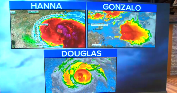
Hanna is one of three significant systems churning Saturday morning.
Hurricane Douglas
In the Pacific, Hurricane Douglas is a Category 2 storm with winds over 100 mph. The storm was located 590 miles east-southeast of Honolulu, Hawaii, moving west-northwest at 18 mph.
Because the storm is forecast to weaken and the eye wall may only skirt coastal areas, the system is not expected to produce catastrophic winds. Still, wind gusts over 75 mph are possible.
The biggest threat is huge waves offshore pushing very dangerous surf toward shore. Also, rainfall is expected to total 3 to 6 inches, which may cause mudslides in hilly areas. The storm will weaken and move away on Monday.
Hawaiian Airlines announced Saturday that all transpacific and inter-island flights scheduled for Sunday were canceled.
Tropical Depression Gonzalo
Meanwhile, Tropical Depression Gonzalo is much weaker, with winds decreasing to about 35 mph on Saturday afternoon. The government of Trinidad and Tobago canceled a Tropical Storm Warning that was in effect for Tobago and Grenada.
Gonzalo or its remnants are expected to move across the southeastern Caribbean Sea on Saturday and Sunday.
Behind that, another disturbance emerging off Africa has a good chance of becoming the next named system of the Atlantic season within a couple of days. This system will need to be watched closely, as the computer forecast models show it may become a strong system heading toward the Caribbean and perhaps the U.S. mainland, eventually.
With the main period of hurricane season arriving about two to three weeks early, experts say the U.S. should be prepared for a very trying and active few months ahead.

