Heat wave sizzles parts of the country as floods and severe weather force people from their homes
Little relief appears on the forecast for millions across the United States enduring record-setting heat or widespread flooding this weekend.
The National Weather Service said Sunday that the heat wave will shift from the mid-Atlantic to portions of the southeast and southern Plains by Monday. Meanwhile, widespread storms will bring the threat of flash flooding, damaging winds and tornadoes for a second day in New England.
Elsewhere, severe storms and rainfall are on the forecast. Here is what we know:
Heatwave shifts its focus
The record-setting heat wave that has kept roughly 15 million people under a heat warning – the highest level of alert by the National Weather Service – will shift from the mid-Atlantic to portions of the southeast and Lower Mississippi Valley on Sunday. Temperatures are expected to remain in the upper 90s with stifling humidity helping to push the heat index into the low 100s. There will be little relief overnight as low temperatures will remain in the mid-70s.
"Numerous record-tying/breaking highs are possible," the National Weather Service said Sunday.

"It's more important for people who are going to be outside to stay hydrated, because heat, humidity and low winds, even if you're in good shape and not really acclimated to it, it could be a danger, " said Bruce Thoren, a National Weather Service meteorologist in Oklahoma. "It happens quickly."
The cities of Washington, D.C., Baltimore and Philadelphia all saw record heat on Saturday, with more high temperatures expected Sunday.
In the west, temperatures will push past 100 over northern Utah and parts of central and southern California.
"We still have this prolonged heat wave across portions of the Ohio Valley and into the Northeast," weather service meteorologist Marc Chenard said. "We get a little bit of relief by early in the week, at least in the eastern U.S., the Northeast, but in general above-normal temperatures are going to cover a large portion of the country even into next week."
Last year the U.S. experienced the most heat waves since 1936, experts said. An AP analysis of data from the Centers for Disease Control and Prevention found that excessive heat contributed to more than 2,300 deaths, the highest in 45 years of records.
Chance for heavy rain continues
A system pushing eastward will bring possible heavy rainfall from New England southeastward through the mid-Atlantic into the Upper Ohio and Tennessee Valleys on Sunday. The National Weather Service said the storms could lead to downpours upwards of 2 inches of rain per hour and a threat of flash flooding in some areas.
Forecasters said the conditions over New England are "favorable for the threat of damaging winds and a few tornados."
Marvin Boyd, meteorologist at the National Weather Service in Burlington, Vermont, said a severe thunderstorm warning was issued for parts of northern New York as a storm with wind gusts exceeding 60 mph (95 kph) and the threat of tornadoes heads toward Vermont near Lake Champlain. It is one of several expected to pass through the region on Sunday afternoon.
"It's an unusual alignment of ingredients for Vermont and northern New York to produce a threat of tornadoes," Boyd said.
Meanwhile, in the Upper Midwest, the National Weather Service predicted there is a chance for severe storms with damaging winds and large hail on Monday.
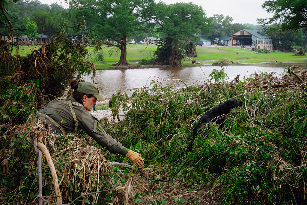
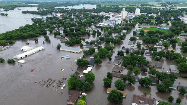
The region is still reeling from severe storms and flooding that forced the evacuation of thousands of people in Iowa and South Dakota.
Rock Valley, Iowa, Mayor Kevin Van Otterloo said Saturday that a state helicopter was dispatched to help residents who were stranded but was called off after boats were able to reach them.
"We've had so much rain here," he said. "We had 4 inches last night in an hour and a half time. Our ground just cannot take anymore."
Gov. Kim Reynolds declared a disaster for 21 counties in northern Iowa, including Sioux County, which includes Rock Valley. In drone video posted by the local sheriff, no streets were visible, just roofs and treetops poking above the water.
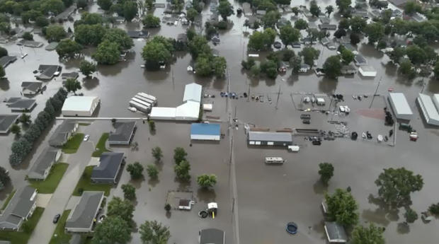
In South Dakota, Gov. Kristi Noem declared an emergency after the southeastern part of the state received heavy rainfall. The town of Canton, 30 miles southeast of Sioux Falls, has received 18 inches of rain.
During a news conference on Sunday, Noem confirmed that at least one person had died in the flooding. She did not give out any information about the victim.
"I want to remind everybody to remember the power of water and the flow of water and to stay away from flooded areas," she said. "We've got a few days in front of us here that'll be a little rough," she added, "but we'll get through it together and do the very best to protect infrastructure, homes and families as we possibly can."
Flooding also closed state highways and county roads in southern Minnesota. Windom, a town of about 4,800 people, received 1.25 inches of rain on top of earlier heavy downpours, and the Des Moines River there had a record crest.
Moisture remains in the Southwest
Meanwhile, monsoon-like conditions will persist through at least Monday with daily shower and thunderstorm chances in the Four Corners region.
In New Mexico, heavy rain and flash flood warnings prompted officials to order some evacuations, with shelters set up for displaced residents.
In Ruidoso, a mountain village in New Mexico, full-time residents will be allowed to return Monday after they were forced out by wildfires, though everyday life won't return to normal.
"You're going to need to bring a week's worth of food, you're going to need to bring drinking water," Mayor Lynn Crawford said on Facebook.
New Mexico Gov. Michelle Lujan Grisham told "Face the Nation" host Margaret Brennan on Sunday that it has been "a hell of a week" in her home state.
"Between dust, heat, flooding, these are not the only evacuations," he said. "We've got flooding evacuations in the north, where the largest wildfire in the history of the United States, one of the largest wildfires in the history of the U.S., it's been really tough on New Mexicans. And I'm grateful to every first responder who puts them first and stands up to make sure they're as safe as we can make them."