Climate change made catastrophic European floods more likely and more intense, study finds
One of the worst disasters in a summer full of extreme weather events — the Western European flooding in July — was made significantly more likely and more intense due to the impact of human-caused climate change, new research shows. More than 200 people lost their lives when rivers overflowed and roared through towns in Germany, Belgium and the Netherlands, washing away structures that had been standing for hundreds of years.
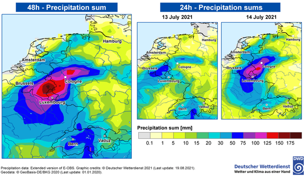
A Belgian government minister described the flood as "one of the greatest natural disasters our country has ever known." As much as two months' worth of rainfall fell in just two days, with some locations picking up nearly 8 inches.
The new study from a team of international scientists at World Weather Attribution has found that the European flooding event — even in today's heated climate — would only be expected to occur once every 400 years in that part of the world. The study also found that the flood event was between 1.2 times and 9 times more likely than it would have been without climate change, and our warmer climate made it up to 19% more intense.
And the researchers warn, "these changes will continue in a rapidly warming climate."
The factors the study takes into account involve fairly straightforward science. For instance, it's well understood that a warmer atmosphere can hold more water vapor and dump more rain. The relationship is simple: for every 2 degrees Fahrenheit increase in global temperature, atmospheric water vapor increases by 8%.
In addition, the attribution study uses climate models to analyze local effects like the impact on convection (downpours) due to a warmer atmosphere. The study can then use computer modeling to compare heavy precipitation in today's heated atmosphere with what they call a counter-factual world — one with cooler, pre-industrial-level temperatures. The difference between the heated and not-heated world tells scientists how impactful climate change has become.
While these numbers are impressive in their own right, they don't tell the whole story. That's because assessments like these focus on statistical and climate model analysis, which do not take into account the climate change impact on large scale weather patterns, like atmospheric steering currents known as the jet stream.
Climate change and the jet stream
The jet stream is a narrow river of air in the upper atmosphere which is responsible for steering storms around the globe and also separating cold air masses from warm air masses. In the case of the European floods there's no debate that a very abnormal jet stream was a significant factor.
The jet stream at the time, from July 12 to 15, was so elongated, wavy and unstable that a piece of it broke off, forming what is called a cut-off low. These type of lows move very slowly, often dumping heavy precipitation over the same areas for a prolonged period of time.
Cut-off lows like the one in Europe can and do happen naturally. But they are made more likely when the jet stream is slower and more wavy. Many climate scientists believe that a warmer climate is indeed making the jet stream slower.
In 2018, Penn State climate scientist Dr. Michael Mann published a paper about changes in persistent extreme summer weather events, coining the rather technical term quasi-resonant amplification (QRA), which refers to large scale weather patterns that are more likely to be semi-stationary due to a warmer climate.
In an email to CBS News, Mann says although he doesn't see evidence that QRA contributed to this flood event, "There's no question that the overall slowing down of the summer jet stream did play a role."
Mann calls attribution studies like this one "extremely conservative" and says that since its modeling doesn't appear to have taken this factor into account, "it is likely understating the role climate change likely played here."
Why was the impact of warming on the jet stream not included in the World Weather Attribution analysis? Simply put, jet stream dynamics are extremely complicated and hard to replicate in climate models. The jet stream also exhibits tremendous day-to-day and year-to-year variability in terms of its location, speed and degree of waviness. This makes determining the impact of climate change on the jet stream extremely challenging, especially for a rapid study like this.
The extent to which climate change is causing the jet stream is become slower and more "wavy" is one of the hottest debates in the climate community. There's one camp of scientists who buy into a concept called the wavy jet stream — the idea that because the temperature contrast from the poles to the tropics is lessening, the jet stream slows down and becomes more meandering and curvy. There's another camp, just as big, who disagree.
Although there is still no clear winner in this climate debate yet, there is one study, coincidentally published just two weeks before the European floods, which seems to be especially applicable. In their research, the authors not only take into account changing rain rates due to increased moisture and convection, but also the change in steering currents in the atmosphere.
Using extremely high resolution climate simulations, the authors were able to show that a future increase in precipitation extremes across Europe happens not only because of more moisture, but also due to slower storm movement of storms, which increases their duration in a given location. What they describe bears a striking resemblance to what happen in mid-July.
"Our results suggest such slow-moving storms may be 14x more frequent across land [in Europe] by the end of the century," the study concludes. The authors say the main reason seems to be a reduced temperature difference between the poles and tropics, which weakens upper-level winds, especially in the fall.
But this impact of a slower, more amplified jet stream reverberates all around the globe. This past weekend in the U.S., record-breaking rainfall occurred both near the path of Henri in the New York City area and to a much larger degree in western Tennessee, where more than 17 inches of rain fell in 24 hours — a new state record.
The Tennessee flooding, which claimed at least 22 lives, was not caused by a large weather system. Rather, it was caused by a very narrow band of heavy rain which got stuck over one small area for an extended period of time.
The result was an extremely rare event — one that would be expected to happen less than once every 1,000 years.
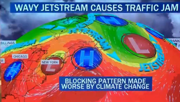
As seen in the graphic below, this can be blamed on a blocked weather pattern — a bumper-to-bumper traffic jam in the atmosphere — which extended well into the Atlantic Ocean and even Greenland. When nothing can move, heavy rain bands persist in the same spot.
While the connection between climate change and extreme weather is still hard for science to put an exact number on, what this summer has made abundantly clear is that greenhouse warming from the accumulation of carbon emissions is amplifying extreme weather all over the globe. These extremes will only increase at a faster rate as the climate continues to warm.


