Atmospheric river means massive snow coming to the West
In what has been the worst fire season in recorded history in California, with twice the burned acreage of any season prior and fires burning months past the end of traditional wildfire season — some just days ago — fortune is about to shift, but to another extreme. A rip-roaring jet stream with embedded atmospheric rivers is primed to pummel California with heavy rain and massive snow over the coming week.
With the flip of a switch, California and the Southwest U.S., will go from the driest six-month stretch in state history to the potential for flash flooding, landslides and snow so deep in the elevations, avalanches will become a danger.
Scientists say that patterns like this, which vacillate between extreme dry and extreme wet, are becoming the new normal, and will likely get worse, due in part to human-caused climate change.
After months with a warm ridge of high pressure around Southern California, effectively blocking most moisture and delaying the wet season by weeks, the pattern is now changing. The next 10 days will feature a barrage of storms slamming into the West Coast - passengers along wicked jet stream centered right over California and the Southwest.
On Saturday, the first in a series of storms was dumping powder on the Great Basin area with Park City, Utah, picking up over a foot of snow. The next storm on Sunday night also looks modest, and on Monday, California's Sierra Nevada range is expected to see about a foot of snowfall. But these systems are a mere preview of what comes next.
On Wednesday, a storm will dive southward along the West Coast spreading heavy rain in the lower elevations and white-out snows higher up from Washington to Oregon to California. And while the storm is decently strong, it's strength is nothing out of the ordinary. Instead, what will turn this ordinary system into an extraordinary snow maker, is its connection to an atmospheric river combined with deceleration.
Although it's early and things may change, once the system reaches south-central California it will likely pivot, wobble and reform. In doing so the heaviest band of moisture associated with what is called an atmospheric river (AR), will get stuck for 36 to 48 hours.
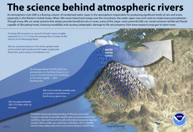
Atmospheric rivers are like fire hoses of water vapor, often with a direct connection to the subtropics. They are known to transfer moisture at up to 15 times the rate of the average moisture flow at the mouth of the Mississippi River. This packs dense moisture into a very narrow band.
When that band is forced upward by the steep rise in terrain as one progresses inland across California, this ascent squeezes moisture out like ringing out a sponge. In the lower elevations it falls as heavy rain. In the mountains it's a wet, heavy, cement-like snow known as "Sierra Cement."
Atmospheric rivers are a common feature in West Coast weather. They are responsible for in excess of 50% of annual rain. Because of their extreme precipitation rates, atmospheric rivers are also responsible for the majority of damage. A study published in 2019 calculated that atmospheric rivers are the primary driver of flood damage in the Western U.S., accounting for an astounding 95% of all insured flood losses in Northern California and the Pacific Northwest.
While it is still too early in the forecast period for clarity, it does appear several feet of snow will bury much of the Sierra Nevada. In just the Wednesday through Friday timeframe, favored areas should pick up 3 to 5 feet. Add to that storms preceding this event and another storm on Saturday, and it seems likely the higher terrain will easily eclipse 100 inches. That will pose an avalanche threat.
But lower down on the hills where the precipitation falls as rain, instead of snow, another danger will emerge.
Dr. Daniel Swain is a climate scientist in the Institute of the Environment and Sustainability at the University of California, Los Angeles. "The biggest concern regarding these incoming storms is the potential for intense rainfall rates in places that have recently (in 2020) experienced large and intense wildfires," Swain told CBS News. "The risk of flash flooding and debris flows in areas that were burned at a high intensity goes up pretty dramatically, since these areas can be denuded of vegetation."
Swain is especially concerned about the Santa Cruz Mountains and Monterey County, where there are numerous large and intense fire scars and which have terrain that tends to favor especially intense precipitation.
Because of a warming climate, California's precipitation regime is changing. Wet season is shrinking and the dry season is expanding, which in turn is helping expand the wildfire season. Despite that, scientists say that climate models do not necessarily project an overall less rainy climate in California. Instead it will be more volatile, with more extended periods of wet and dry extremes.
"Our own research does indeed suggest that most of California will experience increasing 'precipitation whiplash' in a warming climate," Swain said. "That means greater swings between extreme wet and dry years, but also increasingly intense wet spells within otherwise dry periods as well as shorter, sharper rainy seasons."
Swain said this kind of pattern is reminiscent of what we have seen this year. He said his work suggests it is difficult to detect these trends over the past few decades due to natural climate fluctuations, but that a clearer signal would likely emerge right around now (in the 2020s) and then become more distinct as warming continues. "So it is indeed possible we're seeing the early stages of this predicted evolution," Swain said.
This less consistent and less reliable climate makes managing water, wildfire, forestry and agriculture more challenging. It has implications for snowpack, flooding and periods of water scarcity. Swain goes into some of the details in this blog post from 2018.
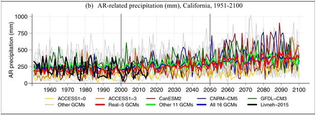
In addition, a greater percentage of rain and snow will fall during the wet season, and specifically in Atmospheric river events. Due to a warmer climate, those atmospheric rivers, scientists say, will be engorged with more moisture in future decades, dumping more extreme precipitation, producing more flash flooding and damage.
The below plot from the study titled "Precipitation regime change in Western North America: The role of Atmospheric Rivers" illustrates that as the climate continues to warm due to human-caused climate change, the precipitation produced from atmospheric rivers will increase, indicated by the upward slope of the lines, each representing different climate models.
However, scientists stress that the magnitude of future impacts which we experience from climate change is really up to us. Humanity controls the knob. The faster we reel in our use of fossil fuels, the less drastic the impacts will be.
