Almanac: America's first aerial photograph
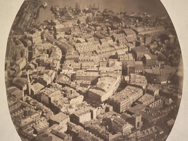
On October 13, 1860, two years after the French photographer Gaspard-Félix Tournachon (a.k.a. Nadar) took images of Paris from a tethered balloon, James Wallace Black took a photograph of Boston from a balloon 1,200 feet up.
Black (1825-1896), an innovative Boston photographer and portraitist, rode aboard Samuel Archer King's hot-air balloon, the "Queen of the Air," as it was tethered at Boston Common, to expose glass plate negatives. The resulting photo was titled "Boston, as the Eagle and the Wild Goose See It" – the first such aerial photograph in America.
The first, but hardly the last.
Today, thanks to satellite imagery and the internet, aerial views of just about anywhere on Earth are available at our fingertips. Not to mention the advent of the drone camera, which allows just about anyone to get a bird's-eye view.
Though when it comes to hands-on aerial photography, few can match Vincent Laforet. Following in the tradition of James Wallace Black, Laforet also photographs cities from above, only he does it hanging out of the open doors of helicopters, sometimes at 11,000 feet or more, often at night.
"It was almost an out-of-body experience, because it's just beautiful up there," he told correspondent Lee Cowan, who in 2015 went along with Laforet on a vertiginous flight over Miami.
Cowan asked, "So, what is it that you're really looking for?"
"I'm looking down there and I'm trying to make order out of chaos, looking for patterns, geometry, color, and light," Laforet said.
Still, for all the differences in technology and technique over the years, the aim of the photographer remains much the same, as Laforet said, "As a photographer, as a visual communicator, you try to find images no one has seen before. That's your goal."
See also:
- Gallery: Stunning aerial photos of Vincent Laforet
- The origins of aerial photography (The New Yorker)
- 10 aerial photographers reveal how they capture the world from above (My Modern Met)
- Aerial Photographs and Satellite Images (USGS)
- Aerial Photographs and Remote Sensing Images (Library of Congress)
- James Wallace Black photographs (Boston Public Library/Flickr)
For more info:
Story produced by Robert Marston.


