Extreme floods, record-breaking winter: Here are the top Minnesota weather stories of 2024
MINNEAPOLIS — It's been a weather year of extremes in Minnesota, with a warm winter, floods and a drought to cap off the summer. There have been, of course, lovely days in between, but Minnesota saw many record-breaking weather events this year.
Let's take a look back at the top weather stories of 2024, in chronological order.
Warmest meteorological winter
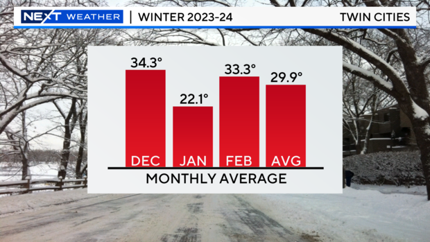
Minnesota started out the year by breaking a record. It was the warmest meteorological winter — which is composed of the months of December, January and February — the state had seen in over a century.
Eighty-five percent of the days in that three-month period saw above-average temperatures, for a combined average of 29.9 degrees. That's more than 10 degrees above average and a full degree warmer than the previous record, which was set back in 1877 and 1878.
The warm temperatures also contributed to a lack of snow; the Twin Cities area only saw 14.3 inches during the three months. Experts say El Niño contributed to the warmth, as well as climate change.
During that time, however, Minnesota also experienced an extreme temperature swing, as an arctic air mass took over much of the United States. High temperatures in mid-January hit the single digits below zero in the metro area.
Spring snowstorm
The warm, dry winter quickly turned around in late March, when a snowstorm dropped upwards of 10 inches of snow in the Twin Cities, and more than two feet near Duluth.
The two-phase snowstorm hit between March 23 and March 27. Most of the metro saw between 6 and 10 inches. The snow was heavy and wet, and snow plows struggled to clear the roads.
Northern lights shows
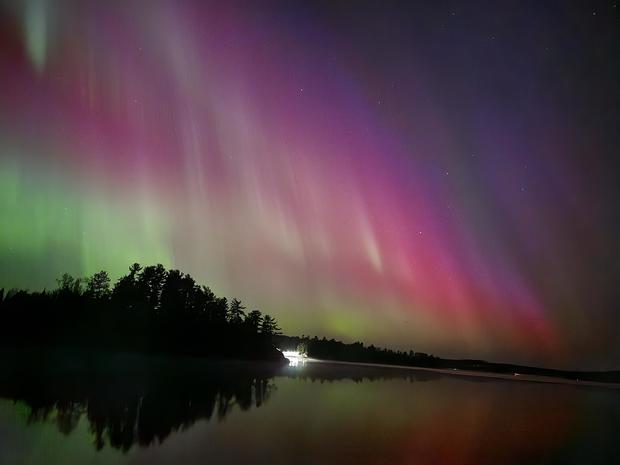
Spectacular displays of northern lights danced across Minnesota skies more often than usual this year.
A massive geomagnetic storm brought the aurora borealis across the United States, Europe and China in May for what was the strongest solar storm the planet has experienced in 20 years. That meant the lights were visible as far south as the Twin Cities.
On May 10, the geomagnetic storm reached what's known as G-5 — the highest on the scale — for the first time since 2003. Minnesotans raced to the best spots to catch the northern lights and returned with stunning photographs. The lights have made appearances in Minnesota a few times since then, most recently in October.
Flood in southern Minnesota
Minnesota transitioned quickly from extreme drought to extreme flooding this year, as the state saw above-average rainfall in April, May and June.
In late June, nearly half of Minnesota was under "unprecedented" flooding, as more than 20 river gauges across the Upper Midwest hit major flood stage. Water levels on the Minnesota, Mississippi and Missouri rivers saw their highest levels in at least a decade.
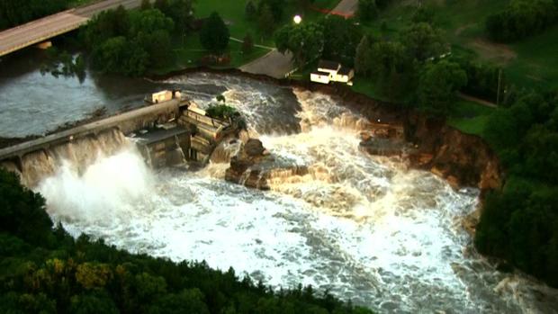
Flooding on the Blue Earth River near Mankato caused an abutment of the Rapidan Dam to partially fail, forcing the family who owns the Rapidan Dam Store to evacuate their home. Later, the iconic home collapsed into the river.
Gov. Tim Walz activated the Minnesota National Guard to help with flooding in Waterville, where parts of the city were underwater due to 14 to 18 inches of cumulative rainfall. Flood water was knee-deep to hip-deep, and residents rode by canoe through flooded streets.
Severe storms during State Fair
Storms raged across the Twin Cities one evening in late August, leaving tens of thousands of people without power. Excessive heat of more than 90 degrees had preceded the storm, and within minutes, temperatures plummeted by almost 20 degrees at Minneapolis-St. Paul International Airport.
Weather sirens rang out at the Minnesota State Fair in the evening, canceling the Grandstand performance and Mighty Midway and Kidway rides closed early for the night.
Early the next morning, officials announced the fair was closed as crews assessed damage and cleaned up debris. It was the first time the opening of the fair had ever been delayed.
Driest September on record
Even after the extreme flooding in June, the lack of rain in September turned yards brown and plants struggled to survive.
MSP Airport saw only .06 inches of rain during the month. Climatologists say it was the driest September on record, thanks in part to the jet stream. Storms missed Minnesota to the north and south, meaning there wasn't much moisture in the air.
Weird "folds" of ice on the Mississippi River
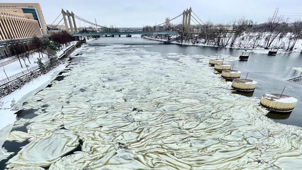
In December, passersby were fascinated by multiple layers and swirls atop the Mississippi River between Third and Hennepin avenues in downtown Minneapolis. You could say it's "icing on the cake" of the first snowstorm of the winter season, bringing joy and curiosity to Minneapolis.
Those layers and swirls are technically called "frazil ice." Area residents are saying they have never seen such a sight.
