Fog to stick around in Minnesota, but rain expected to lighten up
MINNEAPOLIS — After a soggy Friday, the rain has wrapped up for the Twin Cities and will continue to lift northeast through the morning.
The fog on the other hand, is here to stay.
In fact, there is a dense fog advisory in effect until 10 a.m. for places both north and west of the metro.
The fog will be slower to exit, but we may squeeze out a peek of sun Saturday afternoon.
Despite the limited sun, high temperatures will stay mild all weekend with highs close to 40° Saturday and Sunday.
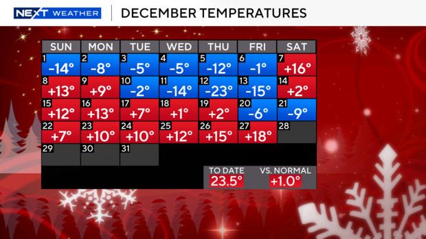
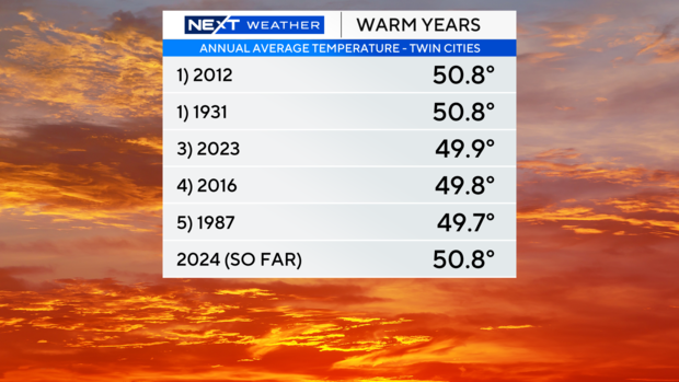
The last two days have been 15-20° above average. The average temperatures in Minnesota in December has jumped to 23.5° currently putting us in a three-way tie for warmest year at 50.8°.
With more significant warmth on the way, we should take the sole #1 spot at 50.9° by Monday.
Freezing fog may create some slick spots on Sunday morning as lows tilt towards 32° on Saturday night.
Some models show a stray sprinkle Sunday afternoon across southern parts of Minnesota, but the day looks largely dry.
Another system tries to slide in early next week, but any precipitation should stay to the south of us.
A northwest wind will blow through the state on Tuesday, ushering in a colder pattern with temperatures in the 20's and 10's to kick off 2025.

