NEXT Weather: One more hot October day, before temps take autumnal tumble

MINNEAPOLIS — The Twin Cities were historically hot on Sunday. The metro reached 92 degrees Sunday, which is the hottest October temperature on record.
Monday's high of 89 was just a degree shy of the record. This isn't normal, but we have some big changes ahead.
Tuesday will start out very pleasant, with the day's high reaching 86, which is still almost 20 degrees above average. The wind picks up and the clouds start to increase from the west.
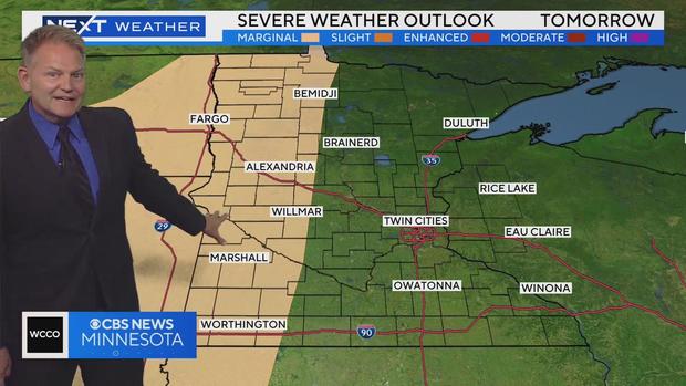
Western Minnesota will start to see spotty showers around lunchtime. And by suppertime, rain will be widespread across the region. A cold front will advance across the state and bring that energy with it from west to east. There is a marginal risk of severe weather, namely some sizable hail.
As the front pushes further east, it will lose a lot of its energy. There may be some spotty showers by the time it gets to the metro and into western Wisconsin, but not much rain is expected, and things should dry out on Wednesday.
Cold air will pour in behind the frontal system. It won't hit us in the face on Wednesday, with highs still in the upper 60s across southern Minnesota. But temperatures will continue to drop like a rock.
Friday's high will only reach 53. It is still windy from the northwest and that will make it feel even colder than that.
It will stay fairly raw on Saturday, but the wind starts to settle down. We'll recover to near average on Sunday.
Enjoy the warmth while we have it, because it won't last.