Monday kicks off unsettled week in Minnesota with multiple rounds of storms


MINNEAPOLIS — The workweek starts with the first of several storms expected over the next several days.
A flood watch is in effect until 1 a.m. Wednesday for two rounds of rain: one throughout Monday, and one arriving on Tuesday evening. Localized flooding is possible, mainly in streams, creeks and rivers.
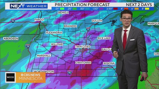
Highs are in the mid-70s on Monday, with many communities expected to see significant rainfall as a system stretching from southern to central Minnesota moves from west to east.
More rain and possible storms will arrive on Monday evening as a warm front lifts north. The greatest threat is excessive rain, hail and wind.
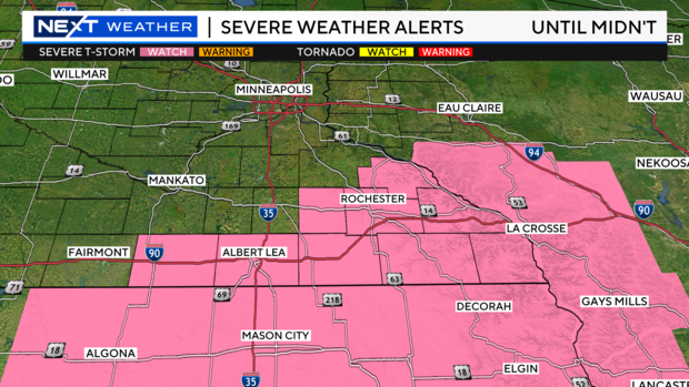
A Severe Thunderstorm Watch is in effect for much of southern Minnesota until midnight. Damaging wind and hail are expected. A brief tornado can't be ruled out.
The Twin Cities will catch a break from the rain overnight and early Tuesday before the cold front swings through in the afternoon and evening. That frontal passage will trigger more rain and possible storms.
Rain chances will shift to the south on Wednesday rain, with highs in the mid-70s.
Highs will reach into the 80s through the weekend, with another 2-5 inches of rain under an unsettled pattern.