Severe storms, tornadoes reported in southern Minnesota before sunny Tuesday


MINNEAPOLIS — Monday will be a wet, cool and gloomy day across Minnesota.
The rain will be a full-day event across central Minnesota, including the Twin Cities. There will be some slower periods, but no real breaks. Most spots will see 1 to 2 inches, while some areas could see up to 4. Flash flooding is a concern.
A tornado watch remains in place for Fillmore and Houston counties until midnight.
As of 9:20 p.m., some strong severe thunderstorms remain across southeastern Minnesota as the Winona sees the back end of the strongest storms. In the Twin Cities, heavy rain should be done for the most part.
WCCO meteorologist Mike Augustyniak says the strongest part of the storm is moving to the east, quickly exiting Minnesota. The area could be drying out by midnight.
Tornadic thunderstorms are not expected to return to Minnesota.
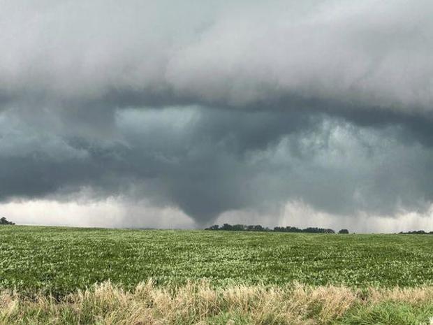
Multiple tornadoes were reported on the ground briefly in southern Minnesota earlier Monday evening. Tornadoes were reported near St. James, Waseca, Wells and Twin Lakes, according to the NWS.
Xcel Energy says heavy rain and strong winds caused downed trees and outages affecting 18,000 customers across the Twin Cities. The storm knocked out power at the WCCO station, knocking it off the air around 9 p.m.
High pressure will move in on Tuesday, bringing the sun back with it. Highs will jump to the mid-70s. Temperatures will be similar for the rest of the week.
Thursday will bring another chance for showers and storms.