Pop-up storms move in Monday evening, Tuesday morning before better weather returns
MINNEAPOLIS — Things will stay unsettled for the next couple of days before more favorable weather returns.
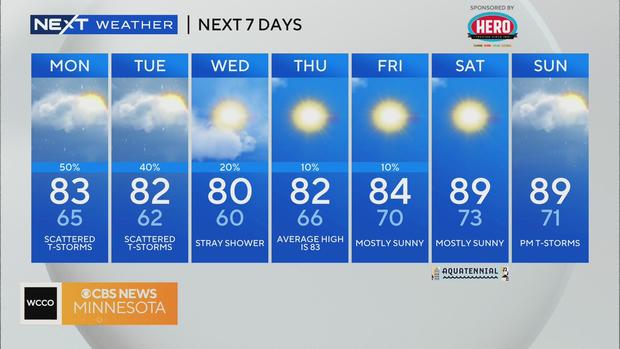
Expect pop-up storms on Monday in the afternoon and evening hours, with spells of sunshine and clouds as well. Highs will be in the lower 80s.
The National Weather Service issued a Severe Thunderstorm Warning that expired at 6:30 p.m. for parts of Hennepin, Dakota, Ramsey, Washington and St. Croix counties.
According to Xcel Energy's outage map, as many as 9,000 customers in the Twin Cities were without power Monday evening. By 10:30 p.m., that number has gone down to about 2,500.
Tuesday will also bring a chance of storms, mostly in the morning hours. Then, things start to dry out and some sunshine makes its way in. Highs will be similar to Monday's.
As we head into midweek, high pressure starts to move in, allowing for smoother weather, temperatures in the lower 80s and sunshine.
We'll get slightly warmer by the end of the week, with highs returning to the upper 80s by the weekend. Saturday night has a chance of rain.

