Hot, humid Wednesday will bring possibly severe storms to much of Minnesota

MINNEAPOLIS — Wednesday is a NEXT Weather Alert day due to potentially severe storms arriving across the state later in the day.
Before those storms arrive, it will be a hot and humid day, with a high of 87.
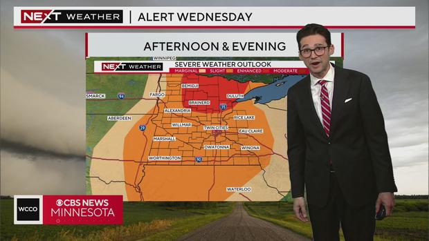
The most active storms are likely to develop in the late afternoon and evening and threaten most of the state. A pocket up north encompassing Brainerd and Bemidji will face an enhanced risk for severe weather, while much of the rest of Minnesota will be under a slight risk.
The main threats with this system wll be large hail and damaging wind, and there's even potential for a tornado.
Some stronger storms were already popping up in western and central Minnesota Wednesday morning. Kylie Brady in Watson shared the photo below of inch-plus hail.

Conditions stabilize on Thursday and Friday, giving us a pair of nice days to wrap up the week. Temperatures will stay in the 80s.
Our next rain system moves in Saturday, and it's likely to be an impactful one.
Next week is trending to be warm and stormy.