Potentially destructive storms expected Monday night into early Tuesday morning


MINNEAPOLIS — Monday will be hot and humid before potentially damaging severe weather moves in during the evening hours.
The forecast high in the Twin Cities is 86 degrees. A heat advisory is in effect for southwestern counties near the Minnesota River. Wind will also blow from the southwest at 20-30 mph.
Isolated showers and non-severe thunderstorms are expected across northern Minnesota in the afternoon hours. They are expected to be generally quiet until dinnertime.
Potentially severe thunderstorms in the evening and overnight hours, however, could produce wind speeds greater than 70 mph along with baseball-sized hail. Due to the risk of destructive storms, a NEXT Weather Alert has been issued for the afternoon and evening hours.
"While we don't want to scare you, this is one of the higher-end severe weather threats we've had so far this season," meteorologist Mike Augustyniak said. "There are a lot of issues out there already with flooding."
The risk for a supercell is high just west of the Twin Cities in the early evening. These are storms that can cause a high amount of damage. The risk extends to most of central Minnesota, too.
Some areas of northern Minnesota reported pea-sized hail earlier Monday evening.
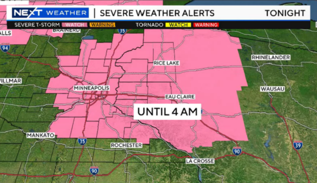
The National Weather Service issued a Severe Thunderstorm Watch until 4 a.m. Tuesday for several Minnesota and Wisconsin counties.
Thunderstorms are expected to continue to pop up west of the Twin Cities after 10 p.m. Monday.
When you wake up Tuesday morning, storms should be out of the area. Humidity will continue to drop throughout the day.
Preparing for the storm
Augustyniak shared some tips for preparing for potential storms:
- Secure loose items in the yard
- Check and clear storm drains
- Check batteries: Phones, flashlights and weather radios
- Make and share your shelter plan
It looks like we may hit some mainly dry days between Tuesday and Thursday. A few of them may even come with highs in the 70s. Wednesday and the first part of Thursday look great so far.
Another round of storms is possible on Thursday night, which again will trend north of the metro and carry into Friday.
The warmest days are Monday and Tuesday, while the rest of the week looks closer to average or maybe a degree or two below.