NEXT Weather Alert Wednesday in Twin Cities as possibly severe storms move in


MINNEAPOLIS — Along with the oppressive heat and humidity, Wednesday is a NEXT Weather Alert day due to possible severe storms.
Wednesday's high will be around 90 degrees in the metro. Storms will develop west and move east out of the Dakotas, arriving in the metro around 5 p.m. and should weaken as the sun sets.
There is an enhanced risk of severe weather — 3 on a scale of 5 — in the southwestern part of the state and the western Minnesota River Valley. Wind damage and large hail are the main concerns.
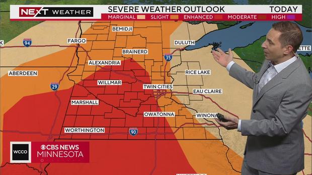
There is also a slight risk — 2 on a scale of 5 — in a wide, northwest-to-southeast swath of the state, including the metro.
Severe weather alerts
As of 10 p.m., there are no severe thunderstorm warnings in Minnesota or western Wisconsin. A severe thunderstorm watch is in effect for much of southern Minnesota.
Flash flood warnings have been issued for southeastern Dakota County and central Goodhue County until 11 p.m., west central Lincoln County, Brookings County, southeastern Kingsbury County, northeastern Lake County and northern Moody County until 11:45 p.m. and Wabasha County until 11:30 p.m.
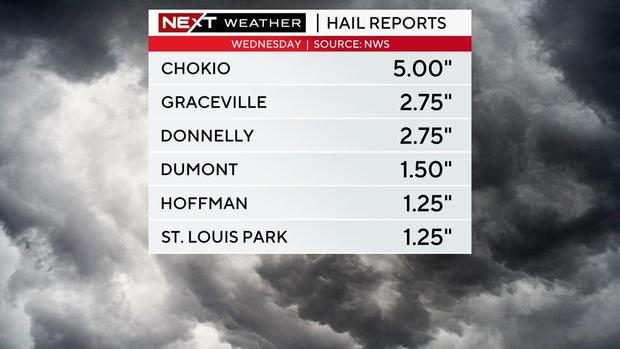
Hail reports from the National Weather Service show hail as big as five inches fell during Wednesday's storms.
Storms down trees, cause power outages
According to Xcel Energy's outage map, more than 10,000 customers in Minnesota were without power as storms rolled through the Twin Cites metro Wednesday evening. That number was down to around 2,800 by 9 p.m.
In northern Minnesota, Lake County Power reports nearly 9,000 customers were without service Wednesday afternoon. As of 9:10 p.m., power has been restored to nearly 4,00 customers, the power company says.
Lightning is believed to have started a fire at a house on the 6500 block of Clover Circle in Cottage Gove, according to the city's fire department.
Beltrami County officials say storms toppled hundreds of trees on Wednesday.
What's next?
Storms hang around overnight into Thursday but will depart in the early morning hours. Thursday's high will be in the lower 80s.
Friday and Saturday will both feature highs around 90 with sunshine.
Temps will drop slightly on Sunday, which will bring our next chance for a passing storm. Highs are trending towards the upper 70s early next week.
Keeping cool in the heat and humidity
With highs near 90 on tap for Wednesday, summer camps are preparing to change plans and beat the heat.
Brigid Murphy, the programs coordinator at St. Paul's Como Park Zoo and Conservatory, says one thing is true.
"We are all trying to stay cool here at the zoo even the animals," Murphy said.
The sea lions won't be the only ones splashing around because campgoers will be joining them.
"We might change our afternoon plans instead of taking a long hike to Como Lake for fishing we might actually have campers bring a swimsuit, a towel and send them through the sprinkler," she said.
For Camp Como, activities are weather-dependent and change to ensure the safety of children.
Zookeepers also change things to accommodate animals on hot days. One class even makes popsicles that they give to polar bears on hot days.
Health leaders recommend drinking plenty of fluids and taking frequent breaks in the shade on these summer days.