Next spring snowstorm will arrive in Minnesota early Wednesday


Weather conditions will shift in the Twin Cities on Tuesday as a cold front moves in and the next storm system approaches.
Highs will drop to the 50s, clouds will increase and winds will be gusty ahead of a spring snowstorm set to arrive overnight.
An area of low pressure will encroach from the south and spread moisture northward as cold air moves in. This will happen early and last through most of Wednesday morning into the afternoon.
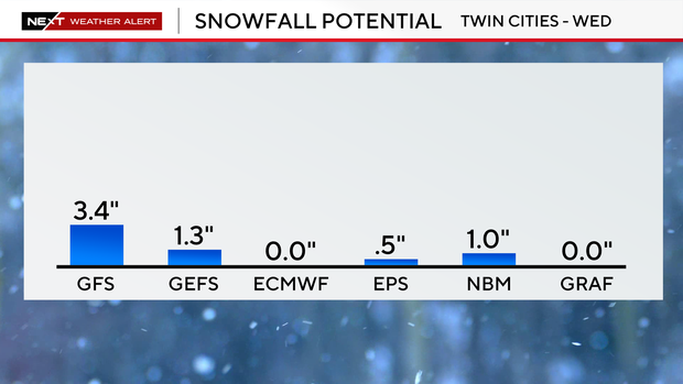
A reasonably sharp swath of heavy snow and strong winds could lead to whiteout conditions, especially in south-central Minnesota. Snow totals will vary greatly depending on where that swath lands, but generally, higher totals are expected to the south with the Twin Cities area expected to get little to no snow. Snow will begin tapering off by the early afternoon as winds gradually weaken.
A winter weather advisory will be in place for the metro on Wednesday, with a blizzard warning in effect for south-central Minnesota. A NEXT Weather Alert will also be in effect.
Southeastern Minnesota could see 6 to 12 inches of accumulation. Parts of the Twin Cities metro that do get snow may only see around an inch.
After the storm clears out, we're in for quiet weather to finish the week. Temperatures will hover in the 40s and 50s.
Another storm system could bring accumulating rain and snow over the weekend, but exact details remain uncertain.