New drought map shows Minnesota slowly recovering after wet April
MINNEAPOLIS — April showers worked overtime this year, continuing to lessen the ongoing drought across most of Minnesota.
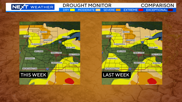
The latest drought monitor map this week shows improvement from southwest Minnesota to the North Shore, where conditions are largely back to normal.
However, moderate to severe drought persists across most of northern Minnesota, and 18% of the state is now in a moderate drought or worse, down from 47% at the start of the year. In all, 31% of Minnesota is still experiencing abnormally dry conditions.
April was especially rainy across southern and central Minnesota. For example, the Twin Cities picked up 4.19" of rain all month compared to the average of 2.91". St. Cloud ended the month nearly 3" above average with 5.51" of rain. Rainfall amounts across northern parts of the state were closer to normal, hence the lack of significant drought improvement.
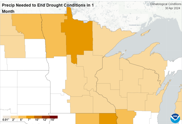
In order to ease the drought entirely in northern Minnesota, the National Weather Service says upwards of 7" of rain would need to fall in one month.
The Climate Prediction Center outlook into early May calls for wetter-than-average conditions, which should help alleviate some of the remaining dryness.
The Minnesota Department of Natural Resources reports that they will "continue to carefully monitor the situation and take steps as outlined in the Minnesota Statewide Drought Plan." The agency also reported that Minnesota has experienced significant drought conditions each year since 2021.

