Weather in South Florida will turn cooler, drier this week
MIAMI: Today will kick off a drier stretch of weather that will continue through the end of the work week.
The disturbance that brought wet weather across South Florida this weekend will shift south of our area. Behind it, expect a drying breeze out of the north. While an isolated shower can't be ruled out, most areas will remain dry with seasonable highs in the middle and upper 80s.
Tuesday, we'll notice a drop in humidity behind this disturbance. Dewpoints will fall into the middle 60s or the first time in a while, leaving us with a very comfortable day on tap for Tuesday! Any rain will be focused down through the Keys tomorrow, leaving the metro area mainly dry.
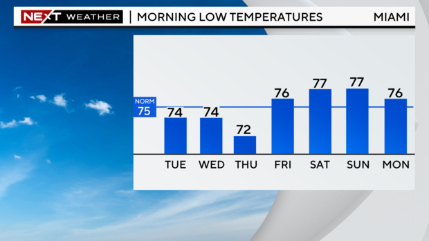
To reinforce this early-week drier air, our first fall front of the season will move through late Wednesday. This will cool or temperatures down, with highs in the low 80s Thursday and Friday, and low temperatures by Thursday morning dropping into the low 70s across the coast and 60s inland.
Rain chances and humidity will be back on the rise by the weekend.
Across the coast, King Tides will bring coastal flooding at periods of high tide through the rest of the week.
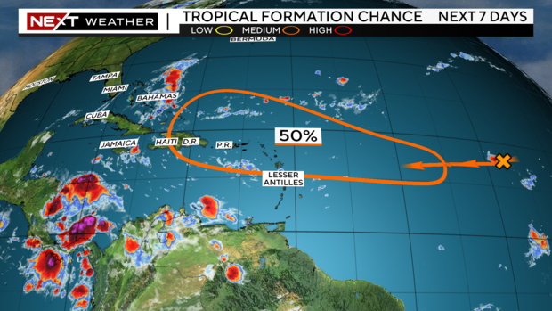
Out across the tropics, we continue to watch a tropical wave in the Eastern Atlantic with a 50% chance of developing into a tropical depression or storm. It will be moving westward and likely approach the Lesser Antilles by the end of the week. For now, it is too soon to know it will pose any threat to the United States.


