Warm and breezy across South Florida, chance for rain goes up Wednesday

MIAMI - Another warm and breezy day is ahead for South Florida on Tuesday under partly sunny skies. Although the chance of rain is lower due to drier air moving in, a few isolated showers may move in on the breeze.
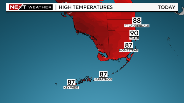
Highs will rise to around 90 degrees in the afternoon which is seasonable for this time of year. The normal high for Miami today is 90 degrees.
Dangerous beach and boating conditions continue due to moderate to strong east winds of 15 to 20 miles per hour with wind gusts as high as 25 to 35 miles per hour.
There is a high risk of rip currents along South Florida's Atlantic coast through Thursday morning, according to the National Weather Service.
"Rip currents can sweep even the best swimmers away from shore into deeper water," the weather service warns. "If caught in a rip current, relax and float. Don't swim against the current. If able, swim in a direction following the shoreline."
A small craft advisory remains in effect for boaters over the Atlantic waters and the Keys through Wednesday morning due to east winds of 15 to 20 knots with gusts as high as 25 knots and choppy conditions on the bay. The National Weather Service says "conditions will be hazardous for small craft and advises inexperienced boaters to avoid navigating in hazardous conditions."
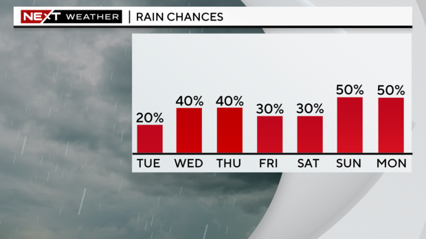
On Wednesday the chance for rain begins to increase due to more moisture. Showers will move in during the morning to midday. It will remain breezy and warm with highs climbing to the upper 80s.
This pattern persists Thursday with scattered showers developing mainly in the morning. Some showers will also be possible through the afternoon.
Later this week, the chance of rain is forecast to rise due to moisture associated with an area of low pressure forecast to develop east of the Bahamas.
The National Hurricane Center is monitoring this area of cloudiness and showers located several hundred miles east of the Bahamas associated with a surface trough and an upper-level area of low pressure. The NHC said this system has a low potential of developing into a tropical cyclone.
"Environmental conditions could be conducive for some gradual development of this system during the next few days while it moves westward or west-northwestward," according to the agency.
Regardless of development, deep tropical moisture associated with this disturbance will likely enhance the potential for more showers and storms this weekend.