Tropical disturbance will bring squally, wet weather to South Florida this weekend

MIAMI - The CBS Miami NEXT Weather team continues to track the tropical disturbance in the Caribbean. It has issued a Next Alert for Saturday as the moisture associated with this wave will produce rounds of heavy rain and the potential for flooding this weekend across South Florida.
The tropical disturbance is drenching portions of Cuba, Hispaniola and the southeastern Bahamas. It is expected to move northwestward across or near Cuba throughout the day and emerge over the Florida Straits on Friday night or Saturday.
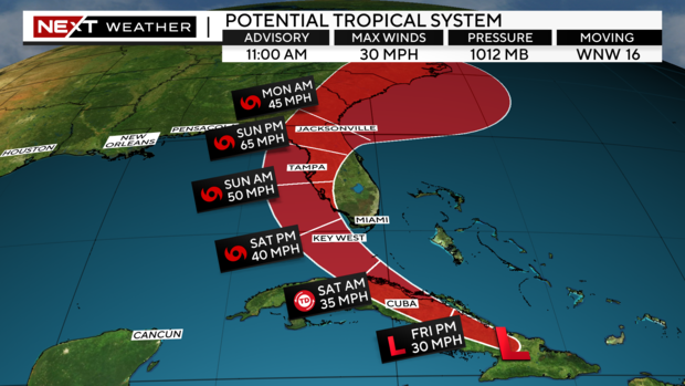
The National Hurricane Center is giving this system a 60% chance of development over the next 2 days and a 90% chance of development over the next 7 days. The National Hurricane Center said a tropical depression is likely to form this weekend over the Straits of Florida or in the eastern Gulf of Mexico near the Florida peninsula.
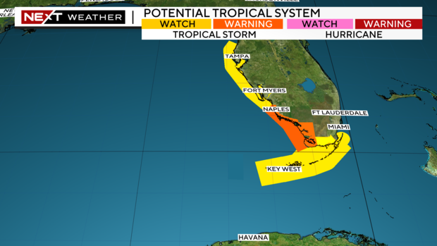
On Friday, at 11 a.m., a Tropical Storm Warning was issued for the southwest coast of the Florida peninsula from East Cape Sable to Bonita Beach.
A Tropical Storm Watch was issued for the Florida Keys south of the Card Sound Bridge including the Dry Tortugas, the southern coast of the Florida peninsula east of East Cape Sable to the Card Sound bridge, and for the west coast of the Florida peninsula north of Bonita Beach to Aripeka.
Regardless of development, the biggest concern for South Florida will be the potential for rounds of heavy downpours and localized flooding. There is a moderate threat of excessive rainfall in South Florida. Some storms could turn strong and produce gusty winds and frequent lightning.
A heat advisory has been issued once again for Miami-Dade, Broward and Monroe counties from 10 a.m. through 7 p.m. due to "feel likes" temperatures of 105 to 110 degrees in the afternoon. Some showers and a few storms moved across parts of South Florida during the morning. More rain is expected to develop in the afternoon and into the evening.
As the tropical wave moves closer to South Florida, the deepest moisture will increase, and "on again, off again" gusty rainbands will move in throughout the day on Saturday and Sunday.
In addition to the wet weather, the National Weather Service said "Minor to moderate coastal flooding will be possible on Sunday during the high tide cycle along the Gulf coast and the southern portion of the peninsula along the Florida Bay."
As winds and seas increase, hazardous marine conditions are expected to develop on the Atlantic and Gulf waters during the weekend. There will also be a high risk of rip currents along the Atlantic beaches.
Since this tropical disturbance is forecast to move slowly to the north over the eastern Gulf of Mexico and then towards the northeast late weekend into early next week, possibly towards the Florida panhandle, the moisture will linger across the state and keep the chance of rain high for South Florida on Monday, Tuesday and possibly even Wednesday.