Stormy weather expected across South Florida as Helene moves into Gulf

MIAMI - The CBS Miami NEXT Weather team is tracking the tropics as Tropical Storm Helene in the western Caribbean continues to move to the northwest toward the Yucatan Peninsula and western Cuba.
A period of rapid intensification is forecast from Wednesday morning to Thursday afternoon. The latest forecast calls for the storm to be a major hurricane making landfall late Thursday along the Nature Coast. The forecast cone has continued to focus on this area but, as of Thursday morning, has the storm center anywhere between Panama City and Tampa.
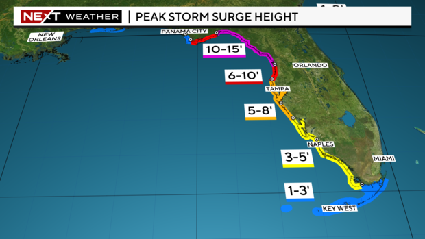
A storm surge watch is in effect along the entire Gulf Coast and the Keys. Near the storm center, 10 to 15 feet of storm surge is expected with lower amounts farther south away from the forecast storm center. In the Keys, 1 to 3 feet of storm surge is expected in addition to tropical storm conditions.
All across the southern Florida Peninsula, gusty squalls will be moving through the area on both Wednesday and Thursday. These have the potential to produce heavy rain, strong wind and a brief tornado. Even though the storm's center is forecast to be well west of the area, it will still have impacts across the region.
Friday the storm will be moving north across the southeastern U.S. Tropical moisture will still be pulled into the system and may remain over the area Friday and through the weekend. Storms will not be as intense but gusty downpours and elevated rain chances will remain in the forecast through the weekend.