South Florida's wet weather brings cooler temperatures

MIAMI - Storms are likely on Monday due to a tropical wave pulling in deep tropical moisture across South Florida.
Some storms developed overnight. More moved in during the morning and rounds of rain are expected later in the day. A few storms could turn strong with the potential for heavy downpours, lightning and gusty winds.
South Florida is not under a heat advisory, as it will not meet the criteria due to the rain and cloud cover that are expected.
Monday morning was a bit more comfortable than previous days, with temperatures in the upper 70s and low 80s courtesy of the rain-cooled air. Afternoon highs will struggle to reach the mid to upper 80s due to the wet weather. It will feel like the upper 90s in Broward and Miami-Dade, and it will feel like 100s in the Keys when factoring in the humidity.
It will be hazy at times due to Saharan dust.
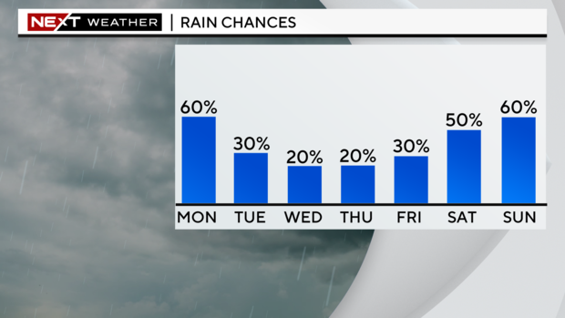
Scattered storms will be possible Tuesday but the chance of rain will not be as high. Saharan dust and drier air will begin to filter in, leading to lower rain chances and hazy skies. Highs will climb to around 90 degrees. The chance of rain will be even lower on Wednesday as the Saharan dust helps suppress any widespread storm development.
Thursday will be hot and humid with highs in the low 90s. Spotty storms will be possible.
Late week into the weekend, the chance of rain will increase due to more tropical moisture around. Highs will stay near normal in the low 90s.