South Florida's morning showers will give way to a drier afternoon
MIAMI - Shower and storm chances will remain highest Monday morning before dwindling by the afternoon as an upper-level area of low pressure finally moves out.
Look for high temperatures in the upper 80s under a mostly cloudy sky.
A drying trend will begin on Tuesday and continue into the Fourth of July as large-scale high pressure builds in over Florida. While we'll still keep some spotty storms in the forecast for Tuesday, coverage will be much less compared to Monday.
Hurricane Beryl is forecast to remain south of the area thanks to this high-pressure pattern as it moves westerly to west-northwesterly this week. This will mean that the sea breeze-driven showers and thunderstorms will be the main story throughout the week along with continued warmth.
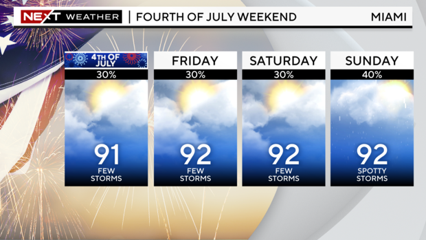
Spotty storms continue through Wednesday, with only a few isolated storms possible for Thursday. Fourth of July will be warm, with highs in the low 90s. The highest rain chances will be focused in the first part of the afternoon, with storms set to move inland by the evening, just in time for firework displays.
Heat index values, or "feels like" temperatures, will quietly creep back up through the week with the potential for heat advisories returning, according to the National Weather Service.