Foggy start across South Florida ahead of warm, humid afternoon
MIAMI - It was a foggy start over South Florida's interior on Thursday morning. A dense fog advisory for Miami-Dade and Broward expired at 9 a.m., however, one remains in effect for the lower Florida Keys through 11 a.m.
Temperatures will warm to the low 80s in the afternoon. A few showers are possible early in the afternoon before a cold front moves through bringing in cooler and drier air for the weekend.
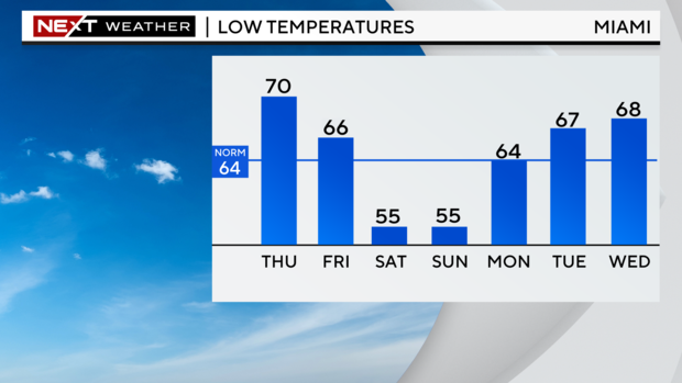
No rain is in the forecast Friday through Sunday as cooler, less humid air lingers over South Florida. Temperatures each morning will start in the middle 50s and climb just above 70 degrees in the afternoon. Expect bright sunshine with a few clouds each afternoon.
The humidity returns next week as the cool north breeze shifts to the northeast and eventually the east. Milder mornings will be followed by slightly warmer afternoons. Enough moisture will be picked up by the breeze to put a few showers back in the forecast for the holiday week.
Winter begins on Saturday. This is the day we experience the least amount of daylight at 10 hours and 31 minutes between sunrise and sunset. Over the next few months, the sun will get higher in the sky as the days get longer and longer.
Why was Thursday so foggy?
Showers and storms followed by a clear and calm night led to a foggy start for some Thursday morning.
Showers and storms that moved from the metro areas Wednesday morning moved to the interior during the evening hours before ending overnight. That rain added a lot of moisture to the surface, which had nowhere to go, giving a clear sky and light breeze.
Warm and humid air at the surface this time of year sets the stage for dense fog to form. The longer the night, the more the temperature can drop. Cooler air can't hold as much moisture, which leads to fog forming.
The fog initially forms over the interior but spreads out over time, reaching portions of the east-coast metro area by Thursday morning. As soon as the sun comes up and heats things up, the fog will disappear or appear to "burn off" with the warmer weather.
A cold front will bring drier air on Thursday night and keep the wind speeds up a bit, so fog is not expected by Friday morning.
Keep an eye out for the next time you have rain followed by a light breeze — these long winter nights help set the stage for a foggy start the following morning.

