Slow-moving storms in South Florida to bring heavy downpours
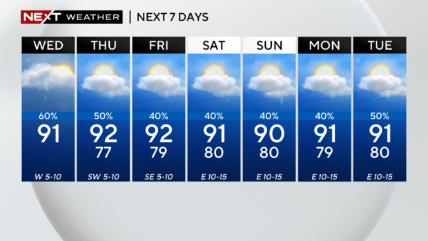
MIAMI - Another round of wet weather is expected to move in Wednesday afternoon and evening. Although the morning was mainly dry, heat and deep tropical moisture will help fuel storms later in the day.
Highs will climb to the upper 80s and low 90s, but it will feel like the upper 90s when factoring in the humidity.
The storms will develop on the Gulf coast and over the Everglades, then move east. Some storms may be slow-moving due to a light southwesterly steering flow and produce heavy rain at times. The National Weather Service said a few storms could turn strong with the potential for gusty winds, frequent lightning, heavy downpours and localized flooding.
There is a low risk of rip currents along the Atlantic beaches due to lighter winds. There are no advisories or alerts for boaters on the Atlantic Waters or in the Keys. Boaters can expect winds of 5 to 10 knots out of the West with seas less than 2 feet and a light chop on the bays.
This rather typical summertime pattern will continue across South Florida through Thursday due to a weak mid-level trough across the region, according to the National Weather Service.
Thursday morning will be mostly dry, and storms will develop in the afternoon and evening. Highs will rise to the low 90s and it will feel like the 100s due to the humidity.
On Friday the weather pattern will begin to transition as the wind flow flips from west to east. Scattered storms will still be possible but the coverage will begin to decrease. Highs will remain seasonable around 90 degrees with plenty of sunshine.


