Slow moving storms develop in the afternoon, move toward coastal metro areas
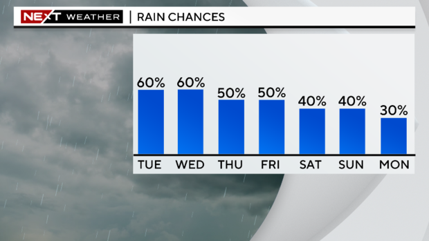
MIAMI - Another round of rain is expected on Tuesday across South Florida.
Scattered showers and storms will develop and move towards the east coast of the peninsula in the afternoon and evening due to a southwesterly wind flow. Some of the storms may be slow-moving due to light winds and may produce heavy downpours and localized flooding.
There is a low risk of rip currents along the Atlantic beaches since winds have subsided. There are no alerts or advisories for boaters navigating over the Atlantic or Keys waters today courtesy of lighter winds.
Highs will climb to the upper 80s and low 90s in the afternoon and it will feel like the upper 90s when you factor in the humidity.
The chance of rain remains high on Wednesday with more widespread rain likely as deep tropical moisture remains in place and a southwesterly steering flow will continue to focus storms on the east coast. It will be mainly dry in the morning and then in the afternoon showers and storms will form with the potential for heavy rain and localized flooding in spots. Highs will stay seasonable at around 90 degrees.
This unsettled pattern continues through Thursday. We'll wake up with mostly dry conditions in the morning and then scattered storms will develop in the afternoon and evening. It will be a little hotter as highs rise to the low 90s and it will feel like the triple-digits when you factor in the humidity.
Friday will be a transitional day as winds begin to shift more out of the east.
This weekend we will see a change in our weather pattern with the onshore breeze off the ocean leading to some showers and storms mainly in the morning and then the rain will push inland and out West in the afternoons.

