Hurricane Milton moves off Florida's east coast. Here's the latest forecast for South Florida
MIAMI – Hurricane Milton made landfall near Siesta Key on Florida's west coast on Wednesday night, then headed out of the state's east coast eight hours later, according to the National Hurricane Center's latest advisory.
South Florida's impact now is minimal.
After moving into the Atlantic Ocean, Milton is expected to gradually lose tropical characteristics and slowly weaken.
Milton had maximum sustained winds of 120 mph when it made landfall, making it a dangerous Category 3 storm, the hurricane center said. Siesta Key, near where it made landfall, is a barrier island located just south of Sarasota.
The National Hurricane Center said Milton brought "devastating rains and damaging winds" inland over portions of Central Florida.
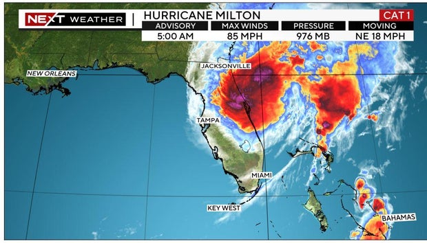
The center said in an 8 a.m. advisory that Milton was about 75 miles east-northeast of Cape Canaveral with maximum sustained winds of 85 mph, a Category 1 storm. Milton was moving northeast at 18 mph.
Additional rainfall of 2-4 inches are expected across the east-central to northeast Florida coast through Thursday morning. "This rainfall will continue to bring the risk of considerable flash and urban flooding, along with moderate to major river flooding," the hurricane center said.
Swells are forecast to still affect portions of the southeast United States. They could cause life-threatening surf and rip conditions.
How is South Florida affected?
All warnings and watches have been canceled for Broward, Miami-Dade an Monroe counties, including the Keys.
A tropical storm warning is in effect from south of Sebastian Inlet to the Palm Beach/Martin county line and Okeechobee.
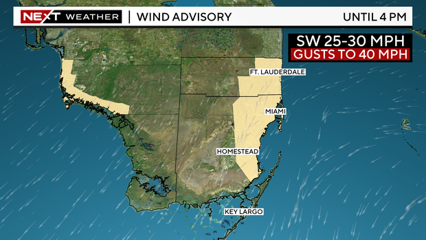
A wind advisory has been put into effect for eastern Broward and Miami-Dade counties Thursday with sustained winds of 25 to 30 mph with gusts up to 40 mph as drier air begins to fill back in.
Hurricane-force winds extended outward up to 35 miles from the center and tropical-force winds extended up to 255 miles.
Tornadoes have been reported, including one on Wednesday that the National Weather Service said hit Alligator Alley in western Broward County near Collier County, with no incidents reported, according to Florida Highway Patrol.

Thursday's forecast
There is a chance of showers and thunderstorms before 4 p.m. then a slight chance of thunderstorms after 4 p.m., according to the National Weather Service.
During the day, sustained winds will be 22 to 30 mph with gusts up to 36 mph. At night they will be 11 to 15 mph. Highs are forecast to be near 89 and lows are expected to be around 74.
Better conditions Friday
The day will be mostly sunny. There will be a 30% chance of showers and thunderstorms between 2 and 8 p.m., according to NWS.
During the day there will be northeast wind around 14 mph with gusts as high as 18 mph. At night, northeast winds will be 9 to 13 mph. Highs are expected to be near 86 and lows around 75.
Good situation Saturday
A 10% chance of showers and thunderstorms are expected after 2 p m. until the evening and then 10% through 8 p.m. It is expected to be mostly sunny with a high near 86. Northeast winds will be around 11 mph during the day and 6-9 mph at night.
Highs are expected to be near 86 and lows around 76.