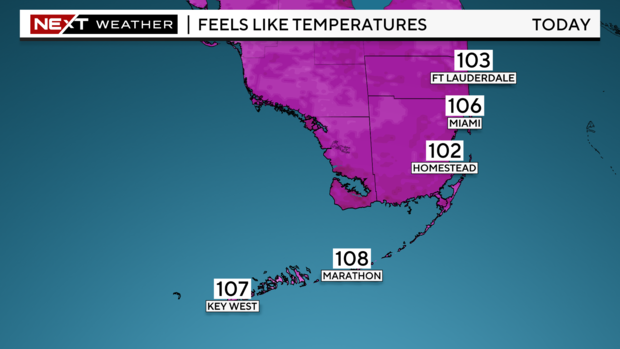
Drier conditions across South Florida, triple digit "feels like" heat

MIAMI - A heat advisory has been issued for Miami-Dade and Broward through 7 p.m. on this final day of July due to "feels like" temperatures forecast to reach 105 to 110 degrees.
The National Weather Service urged people in South Florida to stay hydrated and in the air-conditioning to avoid heat exhaustion. On Wednesday, most of South Florida is under a major heat risk of heat-related illness which means the extreme heat could affect anyone without proper cooling or hydration.
A few showers moved across parts of South Florida during the early morning hours. The afternoon will be drier due to Saharan dust moving in. The southeast breeze will help steer storms that develop towards the interior and the West Coast. With less rain expected, we will see more sunshine and highs will soar to the low 90s. When you factor in the humidity it will feel like the triple-digits.
The chance of rain stays low on Thursday as drier air and Saharan dust remain in place. Spotty showers will be possible Thursday morning but the storms will move inland and towards the Gulf Coast later in the day. Highs will rise once again to the low 90s. Scattered showers and storms will be possible on Friday as the moisture increases.
The weather this weekend will all depend on what happens with the disturbance in the tropics.
The National Hurricane Center says the large tropical wave east of the Lesser Antilles has a 60% chance (a medium potential) of developing into a tropical depression late week or this weekend. This disturbance is forecast to move west-northwest on the south side of the Atlantic ridge of high pressure over the next few days.
By Friday and into the weekend there is a lot of uncertainty regarding the forecast track and intensity of this system.
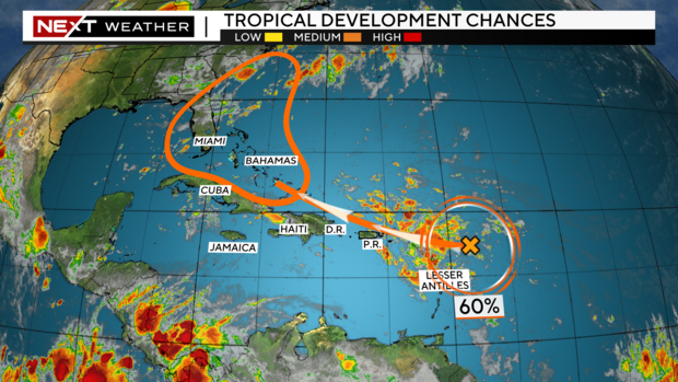
Some models indicated a stronger system could turn north a bit sooner over the Bahamas. A stronger system could mean most of the heavy rain would stay east of South Florida. Other models show a weaker system moving west near Florida and possibly the Gulf of Mexico which would lead to a more sloppy scenario with more rain and wind for South Florida possible this weekend. It is too soon to say what, if any, impacts South Florida will have this weekend.
The CBS Miami NEXT Weather team will be closely monitoring the progress of this tropical disturbance and will have updates on air and online as we gather more data.