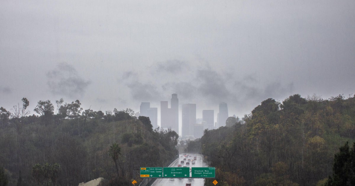
Tropical Storm Debby threatens Southeast with flooding, record-setting rain as mayor warns of potential "obliteration"
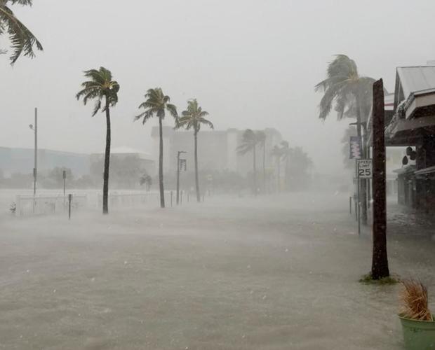
Tropical Storm Debby reached Florida's gulf coast early Monday as a hurricane, bringing with heavy rain and flooding as it slowly passed over the northern part of the state. It was later downgraded to a tropical storm, but forecasters warned that record-setting rain could pummel coastal Georgia and South Carolina in the coming days — and the mayor of Savannah, Georgia, warned the deluge could mean "obliteration" for some parts of the city.
The storm made landfall as a Category 1 storm hurricane near Steinhatchee, a tiny community in northern Florida of less than 1,000 residents. The storm came ashore in one of the least populated areas of Florida, but forecasters warned heavy rain could spawn dangerous flooding.
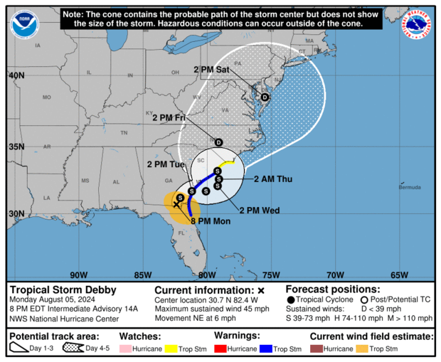
Debby was slowing down after making landfall, and the National Hurricane Center said that the anticipated rainfall totals along its path are so massive in part because the storm is lingering over each place it passes.
As of 11 p.m., Debby had sustained wind speeds had fallen to about 45 mph. Meteorologists said the storm was located about 30 miles west of Brunswick, Georgia, and 60 miles north-northwest of Jacksonville, Florida. It was traveling at around 7 mph. The storm was moving slowly to the northeast, and was expected to decrease in speed as it turns to the east and then, on Tuesday, to the north, forecasters said.
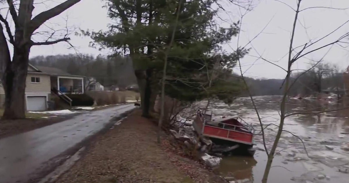
Looking out over the Steinhatchee River from the condo above the marina he operates, Chris Williams said he was feeling blessed that the damage wasn't worse. Williams said his power went out at about 5:30 a.m. Monday as the storm was washing ashore, jamming the dock-studded riverfront with tree debris and barrels.
The small community where Hurricane Debby made landfall is roughly 20 miles from where Hurricane Idalia crashed ashore less than a year ago.
"Two in less than a year is pretty bad," Williams said. "You do everything you can possibly do to prepare. And when you've done that, clean up and put it back together and move forward."
"That part of the coast is a very vulnerable spot," said John Cangialosi, a hurricane specialist with the National Hurricane Center. Some areas have already received 10 to 12 inches of rain.
More than 160,000 customers were without power in Florida and Georgia on Monday night, according to PowerOutage.us.
Florida Gov. Ron DeSantis said some 17,000 linemen are working to restore electricity. He warned residents in affected areas to sit tight until conditions are safe.
"When the water rises, when you have streets that can be flooded, that's hazardous," DeSantis said. "Don't try to drive through this. We don't want to see traffic fatalities adding up."
Debby brought heavy rainfall, wind and storm surge to the Tampa Bay area, making driving conditions dangerous, CBS affiliate WTSP reported. A truck driver was found dead early Monday after he lost control of his tractor trailer and collided with a concrete wall along a wet Interstate 75 in the Tampa area.

East of Steinhatchee, a 38-year-old woman and a 12-year-old boy were killed late Sunday when the car she was driving on a wet road struck a median and then overturned off the road. A 14-year-old boy who was a passenger was hospitalized with serious injuries, according to the Florida Highway Patrol.
A 13-year-old boy died Monday morning after a tree fell on a mobile home located southwest of Gainesville, according to the Levy County Sheriff's Office.
At least one person was killed in Georgia on Monday when a tree fell through their home in Moultrie, the coroner confirmed to CBS News.
None of the formidable rainfall estimates or related flood warnings have changed since Debby made landfall, even after it was downgraded to a tropical storm.
The storm brought more than powerful winds and storm surge to Florida — it also washed ashore cocaine worth more than $1 million onto a beach in the Flordia Keys, the U.S. Border Patrol said.
Fears of "obliteration" in parts of Savannah
In Savannah, Georgia, local leaders said flooding could happen in areas that don't usually get high water if Debby stalls out over the city.
Savannah Mayor Van R. Johnson II told CBS News that Debby could unleash as much as 30 inches of rain in some areas in the coming days — an amount in many areas that "means obliteration," Johnson said, adding, "It is forecast to be a historic event for Savannah."
In South Carolina, Charleston County Interim Emergency Director Ben Webster called Debby a "historic and potentially unprecedented event" three times in a 90-second briefing Monday morning. President Biden later on Monday approved emergency declarations for South Carolina and Georgia.
The city of Charleston has an emergency plan in place that includes sandbags for residents, opening parking garages so residents can park their cars above floodwaters and an online mapping system that shows which roads are closed due to flooding.
North Carolina and South Carolina have dealt with three catastrophic floods from tropical systems in the past nine years, all causing more than $1 billion in damage.
In 2015, flooding rains fed by moisture as Hurricane Joaquin passed well offshore caused massive flooding that nearly knocked Columbia's water system offline.
In 2016, flooding from Hurricane Matthew caused 24 deaths in the two states and rivers set record crests. Those records were broken in 2018 with Hurricane Florence, which set rainfall records in both Carolinas, flooded many of the same places and was responsible for 42 deaths in North Carolina and nine in South Carolina.
In Savannah, Jim Froncak piled sandbags into his pickup truck on Monday, as rain was already falling. He said a recent thunderstorm caused so much flooding that he and a friend were able to kayak down a street.
"That was just a thunderstorm," he said. "So, who knows what could happen with this?"
Debby is the fourth named storm of the 2024 Atlantic hurricane season after Tropical Storm Alberto, Hurricane Beryl and Tropical Storm Chris, all of which formed in June.