Storms to bring rain, wind, and potential debris flows in recent burn scar areas
A series of storms will bring rain and gusty winds to the region from Tuesday through Wednesday, with a second storm expected Friday, carrying a small risk of heavy rain.
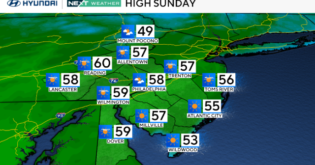
The National Weather Service notes that a warming trend will continue Sunday, with fair skies and some coastal low clouds. These clouds and patchy fog may clear slowly, keeping temperatures cooler near the coast, while inland areas will see highs in the 70s.
Winds will increase by Monday afternoon, with the possibility of reaching advisory levels across the Antelope Valley foothills, according to the NWS.
Forecasters say the storm will move eastward overnight Monday and into Tuesday, and rain chances will increase. By 3 a.m. Tuesday, rain is expected to reach several counties, with gusty winds likely reaching advisory levels across the mountains of Los Angeles County and beyond.
"Rain chances will increase Tuesday across Santa Barbara, the central coast, into Camarillo and into Los Angeles too," according to KCAL9's Meteorologist Alex Biston. "Rain spreads over Los Angeles, Orange County, and the Inland Empire, as we head into Wednesday."
Rainfall totals could range from half an inch to an inch and a half for Los Angeles and Ventura counties and one to three inches in the foothills and mountains, according to the NWS.
Biston said that there will be a chance of rain through Thursday and Friday as a second storm system moves in. The heaviest rainfall is expected late Tuesday into early Wednesday. There is a slight risk of moderate debris flows in areas affected by recent fires.
Todd Hall, a senior Meteorologist for the NWS, said there is a 10-20 percent chance of higher intensity of rates that could bring mud and debris flows. Those who require assistance with sandbags or debris removal from their properties are urged to call 800-675-4357.