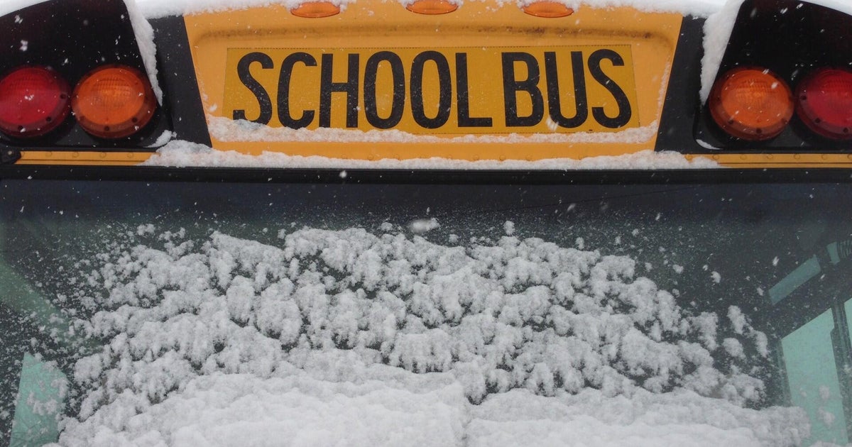
Winter storm: Heavy wind, snow in Southern California
Another storm has arrived in Southern California, with forecasters predicting that exceedingly low temperatures, paired with strong winds, could create an unusual situation for the normally sunny Southland.
The storm began in some areas late Tuesday evening and is expected to last through the weekend, with a significant impact expected for much of the region.
"A strong cold front will move over southwest California through Wednesday morning with very windy conditions and rapidly falling snow levels," the National Weather Service said. "Cold, showery weather will persist until an unusual winter storm brings periods of heavy rain and heavy mountain snow to the region Friday through Saturday night."
The complex storm brings along a slew of weather warnings and watches, as temperatures below freezing could bring snowfall levels down to areas located at elevations just 1,000 feet above sea level.
Some regions that could experience rare snowfall include:
- the high desert like the Mojave Desert,
- nearly all foothill areas,
- a large portion of the Inland Empire,
- the Santa Clarita Valley.
Additionally, places like the Conejo, Simi and San Fernando Valleys could see snowfall, including the metropolitan Los Angeles area.
Related: Weather advisories issued for the icy winter storm rocking Southern California
It has been more than a decade since the Southland has seen a storm of this measure, with the Santa Clarita and Antelope Valleys receiving significant snowfall back in 2011.
At around 10 p.m. Tuesday evening, the National Weather Service issued a rare Blizzard Warning for Ventura and Los Angeles County mountain ranges for Friday and Saturday, with "heavy snow with winds gusting up to 75 mph and near zero visibility" expected.
This storm, which will last for multiple days, stands to be a "major disruption-type event for millions of Southern California residents," according to KCAL-News forecasters.
Los Angeles County residents living near mountains will be subject to a winter storm warning from 7 p.m. Tuesday evening until 4 p.m. Saturday afternoon, with up to five inches of snow falling by Wednesday night. Some winds may reach gusts up to 75 miles per hour.
Mountain communities upwards of 4,000 feet elevation should expect anywhere between two and five feet of snow by Saturday, with some areas reaching up to 7 feet. While foothill communities can look forward up to a foot of snow.
"Significant snowfall" is expected on "most major mountain passes," including the Grapevine, where several inches of snow could fall as soon as Wednesday evening.
In the Antelope Valley, residents will be under a winter weather advisory from 4 a.m. Wednesday morning until 4 p.m. Friday, with as many as 6 inches of snow expected in the foothills, and up to 3 inches on the valley floor. Some winds may reach up to 65 miles per hour throughout the week.
Forecasters predict that the early stages of the massive storm will be widespread winds, with most regions experiencing gusts of wind between 30 and 50 miles per hour.
"There will be the potential for tree damage and power outages just due to winds alone through Wednesday, along with travel impacts at our major airports," the NWS said. "Snow levels drop rapidly from the current 6,000 feet range to near 1,000 feet tomorrow."
As the storm continues to move into the area come Thursday, heavier precipitation will begin to fall, with many areas subject to "a threat of urban flooding and issues near recent burn areas."
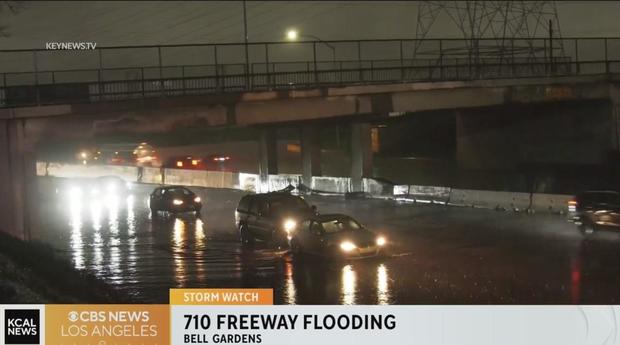
Flooding on 710 Freeway in Bell Gardens
Early Saturday morning, rain flooded portions of the 710 Freeway in Bell Gardens.
Caution is advised when driving on flooded roads, "Turn around don't drown," advises KCAL News Reporter Kalyna Astrinos.
Caltrans: This highway information is the latest reported as of Saturday, February 25th, 2023 at 06:37 AM.
I 710 [IN THE SOUTHERN CALIFORNIA AREA]
NO TRAFFIC RESTRICTIONS ARE REPORTED FOR THIS AREA.
Drivers trapped on flooded streets
Flash flood warning in the Foothills
San Fernando Valley flooding
Flooded streets trap cars across Los Angeles County
The rain has proven to be a formidable foe for many drivers in Los Angeles County.
On Friday afternoon, the National Weather Service issued a Flash Flood Warning for northern Los Angeles County, which includes much of the San Fernando Valley. The warning extended to Santa Barbara and Ventura Counties.
Flash flood warning issued for Los Angeles, Ventura and Santa Barbara Counties
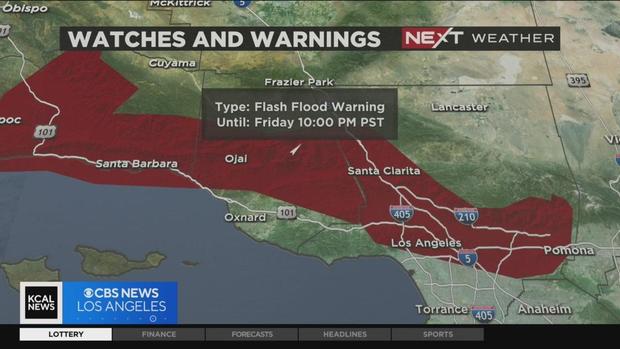
The National Weather Service expanded a Flash Flood Warning for more areas in Los Angeles County until 10 p.m. on Friday.
The areas under this warning include: Burbank, Griffith Park, Universal City, North Hollywood, Pasadena, Hollywood, Downtown Los Angeles, Van Nuys, Beverly Hills, Alhambra, Encino, Northridge, Santa Clarita, Chatsworth, Woodland Hills, Whittier, West Covina, Glendora and San Dimas.
Ventura and Santa Barbara Counties are also under the Flash Flood Warning.
A Flash Flood Warning was also issued for Glendale and Santa Clarita.
Flash flooding will be limited to locations below snow levels, which fall from 4,500 feet to 3,000 feet, including burn scar areas:
- Thousand Oaks
- Simi Valley
- Santa Barbara
- Camarillo
- Lompoc
- Fillmore
- Ojai
- Montecito
- Santa Ynez
- Point Conception
- Chatsworth
- Moorpark,
- Santa Paula
- Carpinteria
- Solvang
- Vandenberg Air Force Base
- Summerland
- Isla Vista
- Rincon Point
- La Conchita
A Flash Flood Warning means that flooding and debris flows are imminent or occurring and residents living in the area should get away from these areas.
Northbound Grapevine drivers being diverted south at Castaic
The Grapevine remains closed Friday afternoon between Castaic and Lebec due to heavy snowfall. Drivers are being turned around and diverted into southbound lanes at a roadblock in Castaic.
Even big trucks were reportedly getting stuck at the top in Lebec, where a foot of snow was reported in some areas.
"It's pretty treacherous conditions up north. There's a lot of snow, a lot of ice, and the visibility's pretty low up there," said CHP Newhall Officer Joshua Greengard. "Right now we have heavy rain in the Castaic area, and it's just a little bit difficult for motorists to try to get through there right now."
The CHP recommends taking the 101 Freeway if drivers must get north or south -- if postponing travel is not an option.
CHP, Caltrans working to keep Cajon Pass clear for traffic
Caltrans crews have been laying de-icing material on pavement to stop black ice from forming on the 15 Freeway through the Cajon Pass.
CHP officers were running traffic breaks to moderate traffic Friday morning and were helping to clear accidents and spin-outs all along the roadway.
"Make sure you've got the right tires, your vehicle's equipped to handle weather like this -- but if you just be patient, I think you'll get there," said truck driver Jason Davis. "But a lot of people are just not prepared for this type of weather."
"Just slow down. Leave maybe a little bit more time to get to your destinations, and slow on the accelerator and slow on the gas as well," said CHP Officer Chris McLeod. "Don't make any sudden movements, because the loss in traction could cause you to spin out."
Winter storm driving tips with Auto Club spokesman Doug Shupe
Drivers frustrated with Grapevine closure
The Interstate 5 Freeway closed through the Grapevine at about 1:30 a.m. Friday due to snowfall. There was no estimate on when the roadways would reopen. A CHP officer tells Tina Patel that drivers should avoid the area until at least Saturday night.
MORE: Winter storm: Grapevine shuts down from Castaic to Lebec due to snowfall
Snow turns to rain on 14 Fwy in Antelope Valley
Hazardous driving conditions through the Cajon Pass
CHP escorting vehicles on 14 Fwy between Acton and Palmdale
California Highway Patrol officers are escorting vehicles in both directions of 14 Fwy between Ward Road near Acton to Avenue S in Palmdale.
Check your local driving conditions with KCAL News NEXT Traffic.
Grapevine shuts down due to snowfall
The Interstate 5 Freeway is closed in both directions through the Grapevine Friday morning due to snowfall.
Northbound lanes of the Grapevine are closed at Parker Road in Castaic. Traffic is already backed up for miles south. Southbound lanes are closed in Lebec.
There was no estimate on when the roadways would reopen. Closures began about 1:30 a.m. Friday. California Highway Patrol officers had been escorting vehicles prior to all lanes closing.
More details: Grapevine shuts down from Castaic to Lebec due to snowfall
All LA County trails closed Friday, Saturday because of bad weather
All trails and dozens of parks are closed Friday and Saturday as Los Angeles County expects to receive heavy rain and wind.
LAX sets record-low temperature amid winter storm
LAX has hit a record-low temperature amid as the most powerful part of the winter storm approaches the area.
According to the National Weather Service, it dropped to 41 degrees at LAX earlier today, tying the record set in 2019. The weather service said the new record happened amid a heavy rain squall around at around 11 a.m.
To read the full story click here.
What are blizzards? Defining the conditions for a blizzard
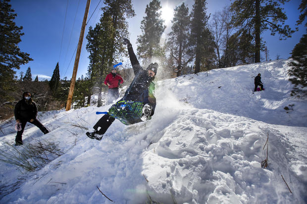
When it snows, make a snowman: A rarity in Yucaipa
It's an unusual sight and experience for Yucaipa. While winter weather -- and snow -- has caused some problems in the area, it's also making for some fun.
Just outside the snow-filled Yucaipa Regional Park Thursday, students said they "were so happy," and "so excited" to stay home and play in the snow after schools were closed due to weather.
Click here to read more.
CHP gives update on road conditions Thursday morning
Big Bear gets fresh snow but 330 access is limited
Agua Dulce sees snowflakes as CHP escorts drivers on 14 Fwy
Cajon Pass driving conditions worsening by the hour
Caltrans provides up-to-date road conditions: Avoid nonessential travel Thursday
Hail on the Hollywood sign
Duarte Mudflow Alert issued for Fish Fire burn scar area
L.A. County issued a Mudflow Alert for Duarte's Fish Fire burn scar area, plus a Yellow Alert and the closure of Mel Canyon Road Thursday night.
More information on Duarte's alerts and closures here.
Flurries coming down in the Cajon Pass
Bear Valley school district snow day
Bear Valley Unified School District closed its schools due to weather conditions Thursday.
The Bear Valley Unified School District states on its website: "Due to inclement weather and unsafe road conditions, there will not be school on Thursday, February 23, 2023. Please stay safe."
20-vehicle crash shuts down 10 Fwy Wednesday night
At least eight people were injured in a 20-vehicle crash on the Interstate 10 Freeway in Yucaipa at Wildwood Canyon Wednesday night.
At about 10:24 p.m. Wednesday, about 20 vehicles piled up on the 10 Freeway in the city of Yucaipa in San Bernardino County.
The incident occurred on the westbound 10 at Wildwood Canyon Road.
Multiple vehicles, including tractor-trailers, were blocking traffic.
Eight people were injured. The freeway was closed in both directions while the incident was cleared. Westbound lanes of the 60 Freeway were also closed.
Roadways reopened at about 1 a.m. Thursday.
High winds pound beaches in Long Beach, Orange County
As the powerful winter storm sends its first blasts into Southern California, gusts howling along the coast sent sand blowing into the air in Long Beach and other shores across Orange County.
The strong winds have already caused some major trouble on Roycroft Avenue where a large eucalyptus tree toppled over Tuesday night. It destroyed four cars including Kyle Naumovski's 10-year-old Honda.
"I was hopeful that I maybe dodged a bullet but no it was all covered," he said.
For the full story click here.
Truck drivers rush to finish routes ahead of storm
Experts are expecting a closure of the Grapevine during the coming winter storm, prompting a number of truck drivers to work quickly in order to finish their routes before they get caught up in slick roads and closures with precipitation just hours away.
For more information on how the storm could affect busy thoroughfares like the Grapevine, SR-14 and more, click here.
Wrightwood expecting several feet of new snow
Wrightwood's Mountain High resort is waiting in excitement as the winter storm's first blasts hit the region.
"This is it! The one we've been waiting for. Conditions are about to go from good to 'Oh my gosh. I can't believe this is So Cal,'" said John McColly, the resort's vice president of sales and marketing.
The resort said it hopes to see several feet of new snow to elevations as low as 3,000 feet. According to the National Weather Service, through Thursday, Wrightwood can expect at most 18 inches of snow accumulation. However, meteorologists believe the snow totals are expected to jump up drastically once Friday comes around — raising the possibility of blizzard conditions.
On Friday, Wrightwood can see a high of 38 total inches of snow, and low of 26 inches of snow. The snowfall is expected to die down as Saturday starts with a relatively modest 9 inches of snow accumulation.
For the full article click here.
Strong winds wreak havoc across South Bay
LA County issues Phase 2 mudflow alert for areas near Fish Fire burn scar
Los Angeles County Department of Public Works officials have issued a Phase 2 Mudflow Alert for residents living near the Fish Fire burn scar in lieu of the powerful storm heading into Southern California.
The alert will remain in place from Thursday morning to Sunday morning due to the heavy precipitation predicted to hit the Duarte area.
As usual during times of heavy rain, residents living from Mel Canyon Road and Brookridge Road to Fish Canyon Road are directed to follow a number of different protocols, including:
- Road closure on Mel Canyon Road from Brookridge Road to Fish Canyon Road beginning Thursday at 11 p.m. and lasting until Saturday.
- Parking restriction on Mel Canyon Road from Brookridge Road to Fish Canyon Road, as well as Deerlane Road between Mel Canyon Road and Greenbank Avenue.
- All trash bins must be removed from the street.
- Friday's scheduled trash pick-up is canceled until Monday.
Antelope Valley residents bundle up ahead of snowfall
Ahead of the heavy snowfall expected in the Antelope Valley — with some forecasters predicting up to half a foot in foothill regions — many excited residents are preparing for the frigid temperatures that will accompany their sudden winter wonderland.
Strong winds topple large tree in Inglewood
Wild wind, high surf battering Orange County coast
Wild winds and high surf battered the coast of Orange County on Wednesday, just another region feeling the impacts of the significant winter storm moving through Southern California.
Despite this, adrenaline junkies and extreme sport enthusiasts were out in force, taking advantage of the whipping winds in Huntington Beach.
Low-level snowfall, strong winds create dangerous driving conditions
With a powerful storm moving through Southern California, bringing heavy precipitation and even snowfall to low-level elevations, many popular freeways are expected to be impacted by the dangerous conditions.
The Grapevine, which usually shuts down during strong winter storms, remained open as of 5 p.m. Wednesday evening, but drivers and residents living in the surrounding area were busy preparing to bundle up and stay home as the weather closed in.
For more information on the potential impact the storm could have on the Grapevine, click here.
In the Inland Empire, including Wrightwood and the Big Bear area, residents were already being battered by snowfall and strong winds, creating icy drives and equally dangerous driving conditions along SR-138 and other mountain roads.
Avoid mountain travel: Snow hits the Grapevine
The National Weather Service advises avoiding mountain travel as light snow is starting to fall on the Grapevine Wednesday afternoon. CHP Fort Tejon reported North and southbound I-5 remain open but there is a possibility CHP will be conducting escorts -- and if road conditions worsen, the Grapevine will close.
Drivers, residents prepare for Grapevine closure ahead of storm
Staying safe on SoCal roads during winter storm
What do you need to know to stay safe on SoCal roads as the big winter storm arrives this week? Caltrans spokesperson Alisa Almanzan offers tips for drivers.
- Limit non-essential travel, delay trips if possible
- Plan for potential closures, scope out alternate routes
- Monitor conditions, anticipate flooding
- Watch out for workers and maintenance crews on roadways
- Check your vehicle's brakes, wipers, tires,
- Fill your gas tank
- Carry tire chains
- Carry food, water, chargers, extra clothing/blankets
Check road conditions across California with the Caltrans QuickMap here.
Grappling with 'graupel' in the Cajon Pass
History of low snow levels in Southern California
Lancaster sees early snow, but none sticks - yet
High winds blow through passes, mountains see snow
High winds take down large tree in Manhattan Beach
High winds, surf prompt closure of Redondo Beach Pier
LA County expected to activate emergency winter motel voucher program
Los Angeles County is expected to enact its emergency winter motel voucher program to aid with the monumental task of housing as many people as they can as an especially frigid storm is expected to hit Southern California.
Already on Tuesday night, the temperature seemed to quickly drop forcing 48-year-old homeless resident Drew to endure a cold night in the Pasadena park he's called home for years.
"Well, I cover up best I can and just gonna have to deal with it," he said. "It's not fun, I'll tell you that. It's hard."
Residents busy bundling up ahead of frigid temperatues
Strong winds whip through Harbor City
Running list of active weather advisories
With the massive storm expected to rock the Southland through the weekend, the National Weather Service has issued a series of weather watches, warnings and advisories for residents to look out for in coming days.
For a full look at the potential impact your hometown may face, check out a list of the active weather advisories issued throughout Riverside, Orange, San Bernardino and Los Angeles Counties here.
Winter storm leaves thousands without power in Santa Barbara County
More than 12,000 residents in Santa Barbara County are without power as the winter storm starts to bring high winds and lower temperatures. The power outages are not as severe in the rest of Southern California, with about 1,000 customers in Los Angeles without power.
As of 10:30 p.m., SoCal Edison reported that the number of residents impacted by power outages in Santa Barbara had dropped, and that a little over 12,000 residents throughout the Southland remained impacted.
Blizzard warning issued for Los Angeles County
In an extremely rare turn of events with the storm sitting over Southern California, the National Weather Service has issued a blizzard warning for mountain ranges in Los Angeles and Ventura Counties.
The warning is expected to last through Thursday evening.
The NWS warns of "low elevation snow, strong winds and very cold wind chills. For the Blizzard Warning, heavy snow with winds gusting up to 75 mph and near zero visibility."
For the latest weather advisories in Southern California click here.
Drivers beware: Grapevine likely to be impacted by looming storm
The Grapevine, the commonly reference 40-mile stretch of the I-5 Freeway that stretches from northern Los Angeles County to Kern County, is often affected by winter storms, when snow begins to fall and create dangerous driving conditions.
Many times in the past, California Highway Patrol officers have resorted to escorting vehicles through the pass when winter storms hit the area.
This incoming storm appears to be no exception to that standard.
For more on the possible weather conditions facing the Grapevine, click here.