Hurricane Sally strengthening as it inches toward Gulf Coast
Hurricane Sally was suddenly getting stronger as it lurked off the Gulf Coast early Wednesday. The National Hurricane Center said Sally strengthened into a Category 2 hurricane with sustained winds of 105 mph, up from 85 mph late Tuesday.
The center said "historic, life-threatening" flooding is "likely" in portions of the northern Gulf Coast due to Sally's excruciatingly slow pace. The storm was crawling north-northeast at a measly 2 mph and forecasters said it would continue to creep along.
Hurricane conditions were spreading spread onshore from Pensacola Beach, Florida westward to Dauphin Island, Alabama.
The center said Sally could dump up to two-and-a-half feet of rain in some places and produce storm surges as high as seven feet. Tornadoes were possible, as well.
As of early Wednesday, Sally's eye was about 60 miles south-southeast of Mobile, Alabama and 55 miles southwest of Pensacola, Florida, the hurricane center said.
Flash flood emergency in Mobile, Pensacola
The National Weather Service Mobile, Alabama office has declared a Flash Flood Emergency for parts of the Mobile and Pensacola, Florida areas:
Police in Pensacola said, "Flooded roadways and intersections, along with hazardous debris in roadways have become too numerous to list. Please stay off the roadways now."
Hundreds of thousands without power already
More than 230,000 homes and businesses were reported without power in Alabama, Louisiana, Florida and Mississippi as conditions deteriorated with Hurricane Sally slowly approaching.
A website tracking electricity use nationwide, poweroutage.us, reported those disruptions early Wednesday as Sally churned off the northern U.S. Gulf Coast.
Driving rain blew sideways and gusty winds buffeted street signs and trees.
In the Florida Panhandle city of Pensacola, water crept into downtown streets, forcing a utility truck to pass through the standing water.
-- CBS/AP
Sally's track shifts slightly east
Hurricane Sally's track has shifted slightly east, according to CBS affiliate WKRG-TV. The storm is expected to make landfall near the Alabama-Florida border.
2 casino boats break loose in Alabama
Two large casino boats broke loose Tuesday from a dock where they were undergoing construction work in Bayou La Batre, Alabama. M.J. Bosarge, who lives near the shipyard, said at least one of the riverboats had done considerable damage to the dock.
"You really want to get them secured because with wind and rain like this, the water is constantly rising," Bosarge said. "They could end up anywhere. There's no telling where they could end up."
CBS affiliate WKRG-TV said nobody was injured and tug boats were on the scene. The situation seemed under control, the station added.
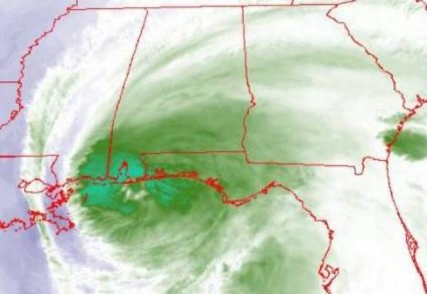
NOAA satellite shows Hurricane Sally at night
NOAA's GOES-16 satellite composite loop shows lightning as the slow-moving Hurricane Sally swirls near the Gulf Coast.
Flash flood watch issued for north and central Georgia
The National Weather Service has issued a flash flood watch for portions of central Georgia from Wednesday to early Friday morning before Hurricane Sally makes landfall on the Gulf Coast. While the storm will not touch down in Georgia, state officials are anticipating floods and storm surges from the hurricane-force winds.
The hurricane's rain bands have increased periods of heavy rainfall around the central Georgia area. While the storm is expected to weaken to a tropical depression, experts are predicting between 3-6 inches of rain in some areas. Georgia residents are advised to keep an eye out for rising or quickly changing water levels, including around rivers, streams, and small creeks.
Sally is expected to make landfall in Mississippi, which will most likely bear the brunt of the damage, however, it will continue to move inland as a tropical depression when it nears Georgia.
South Carolina reservoirs brace for Sally rainfall
South Carolina environmental officials are urging owners and operators of reservoirs across the state to be ready to handle potentially heavy rainfall in the coming days as Hurricane Sally makes landfall and drenches inland areas.
The Department of Health and Environmental Control on Tuesday said the agency had performed "pre-hurricane season assessments of all dams of concern."
In issuing guidance, Jill Stewart, director of DHEC's Dam Safety and Stormwater Permitting Division, said owners should also notify anyone operating a dam downstream of their property if they are lowering water levels, and also clear trash and debris from spillways.
In 2015, more than 40 dams across the state failed in devastating floods that stranded homeowners and forced some into recreational boats to rescue neighbors. The historic rain and flooding led to 19 deaths and caused about $2 billion in damage.
A year later, Hurricane Matthew caused about 25 more dams to fail and another round of flooding.
After Matthew, South Carolina's environmental agency requested more than $5 million to stabilize or tear down damaged dams and inspect others. State lawmakers also gave the agency $3 million to boost dam safety.
2020 hurricane season might exhaust list of storm names
The increase in storms during the 2020 Atlantic Hurricane season might exhaust this year's list of storm names. Five tropical storms in the Atlantic basin have been named, which ties a record for the most tropical cyclones in a basin at one time since September 1971, according to the National Hurricane Center.
Hurricanes Paulette and Sally and Tropical Storms Rene, Teddy and Vicky have all been confirmed as tropical storms, leaving Wilfred as the only available storm name left, according to the World Meteorological Organization, the authority in charge of naming storms.
As of September 15, at least one more low-pressure area has already begun forming near Cabo Verde, which researchers say has a 50% chance of becoming a tropical cyclone formation within the next 48 hours.
The WMO rotates alphabetical lists of storm names every six years. The lists alternate male and female names, and only exclude five letters of the English alphabet: Q, U, X, Y and Z.
If more than one storm forms before the end of the season, researchers will use the Greek alphabet to name future cyclones. This has only happened once in WMO history, after hurricanes Katrina, Rita, and Wilma all touched down in 2005.
While the agency historically retires storm names that cause catastrophic damage or casualties, its voting body has decided that no names from the Greek alphabet will be retired, regardless of storm outcome. Only Hurricane Sally is currently predicted to make landfall in the U.S.
Louisiana prepared to help Mississippi and Alabama
Louisiana Governor John Bel Edwards on Tuesday said the state's disaster relief personnel and equipment will be prepared to aid both Mississippi and Alabama when Hurricane Sally makes landfall early Wednesday. President Trump has approved Louisiana's emergency disaster declaration, but updated tracking shows Sally's eastern shift will hit Mississippi much harder than Louisiana.
At a hurricane news conference, Bel Edwards called the storm's new trajectory "good news" for Louisiana, but "bad news" for bordering states. While Hurricane Laura has caused over $1.6 million in damages to agriculture and forests, Louisiana's estimated rainfall has decreased "dramatically" since the storm's movement and is expected to slow as Sally makes landfall in Mississippi.
While rain has decreased, flooding caused by storm surge in lower parts of the state are still considered a major concern. Over 13,000 Louisiana residents have evacuated their homes and are sheltered around New Orleans, while over 5,000 evacuees closer to the state line have taken refuge in parts of Texas.
Homeless dogs evacuated from hurricane's path
The Humane Society of North Texas is working with the ASPCA and Wings of Rescue to evacuate dogs left in the path of a hurricane. The group received 46 homeless dogs, which will be made available for adoption in the coming days.
"The Humane Society of North Texas will continue to assist neighboring states in need when catastrophes occur putting the lives of numerous pets at risk," communications director Cassie Davidson said.
Wings of Rescue officials said Louisiana shelter workers - many of whom had their personal lives impacted by Hurricane Laura - banded together to care for and save the pets.
The animals were flown to the Humane Society of North Texas and the Houston SPCA. The groups are working to move nearly 300 animals impacted by Hurricane Laura and Hurricane Sally to shelters across the country.

Louisiana governor warns of storm surge
Louisiana Governor John Bel Edwards said storm surge from Sally is expected in some low-lying areas of the state.
"We will monitor and prepare to help our neighbors in Mississippi and Alabama while also continuing our efforts to recover from #HurricaneLaura," he tweeted.
Parts of Mississippi are experiencing storm surge
Parts of Mississippi are experiencing storm surge as Hurricane Sally starts to inundate the Gulf Coast. CBS affiliate WJTV is reporting flooding in the cities of Pascagoula and Pass Christian.
Local police tweeted images showing the impact of the storm and urged residents to stay safe.
Hancock, Harrison, and Jackson counties in Mississippi are forecast to see up to five feet of ocean surge above a two-foot high tide, WJTV reports.
Authorities shut down roadways
Authorities along the U.S. Gulf Coast are shutting down some roadways and residents are clearing out or hunkering down.
The causeway to Dauphin Island in Alabama has been closed, and they're closing down the Bankhead Tunnel in Mobile until an expected storm surge recedes.
Downtown Mobile is nearly deserted, with businesses boarded up and protected by sandbags.
Rain was starting to intensify Tuesday along the I-10 highway that runs parallel to the coast through Louisiana, Mississippi, Alabama and Florida. Businesses along the highway exits appeared to be largely closed, and electronic messaging boards on the highway say that a hurricane warning for the area is "in effect."
In Gulfport, Mississippi, white plastic bags hung over some gas station pumps, showing they're out of gas. And along a bayou, shrimp boats were being tied up as shrimpers batten down ahead of the waves and storm surge.
Curfew for Alabama's Orange Beach
A curfew for the Alabama coastal city of Orange Beach, located in Baldwin County, will be in effect from 8 p.m. on Tuesday to 6 a.m. Wednesday.
"A hurricane warning remains in effect for Baldwin County," the City of Orange Beach said in a Facebook post Tuesday morning. "A significant and potentially historic flood event is possible. Hurricane Sally is expected to produce heavy rains, tropical storm force winds, flash flooding and high surf along the Alabama Gulf Coast."
"It will also be a prolonged event given the slow movement of Sally."
Sally is drifting "at the speed of a child in a candy shop"
Hurricane Sally is drifting north at a speed of about 2 to 3 mph – "the speed of a child in a candy shop," said John De Block of the National Weather Service.
As a result, the eye of the storm is going to take a while to get to the Gulf Coast, "and we're looking at about tomorrow morning now, a little bit later than we had been talking about earlier," De Block said at a press conference with Alabama's governor Tuesday morning.
Winds are expected to be about 80 mph when Sally makes landfall tomorrow. And record flooding is "very well possible" in the areas of Alabama's Mobile and Baldwin counties, where low-lying areas will be "particularly susceptible to flooding," De Block said.
The storm, however, presents a "forecast challenge."
"Right now the projected path is right up Mobile Bay," he said. "If this forecast continues to shift to the east, and it very well may, that will decrease the amount of storm surge that is encountered in Mobile Bay, which will be good news for them. However, there are plenty of opportunities for the forecast to change."
Alabama governor: "This is not worth risking your life"
Alabama Governor Kay Ivey has urged anyone living in low-lying areas or near the Gulf, Mobile Bay or a river to evacuate if conditions permit.
"I know you all want to protect your family and your property, but this is not worth risking your life," she said Tuesday morning at a press conference.
Sally is shaping up to be a "very dangerous and historic flooding event," said Brian Hastings, director of the Alabama Emergency Management Agency. He similarly urged people in low-lying or flood-prone areas to get to higher ground now, "before we see impacts."
He advised people to prepare for widespread power outages and make sure they have food, water, batteries and a way to connect with assistance.
Latest list of storm warnings
The following warnings are in effect as of 10 a.m. local time Tuesday morning, according to the National Hurricane Center.
A Storm Surge Warning is in effect for:
- Mouth of the Mississippi River to the Okaloosa/Walton County Line, Florida
- Mobile Bay
A Hurricane Warning is in effect for:
- East of Bay St. Louis to Navarre Florida
A Tropical Storm Warning is in effect for:
- East of Navarre Florida to Indian Pass Florida
- Bay St. Louis westward to Grand Isle Louisiana
Mobile mayor urges people to take precautions
Sandy Stimpson, the mayor of Mobile, Alabama, is urging people to take precautions as winds and rain hit the area.
Alabama residents wake up to torrential rainfall
Residents along Alabama's Gulf Coast were waking up Tuesday to torrential rainfall, CBS Mobile affiliate WKRG reports.
Police in Baldwin County's Orange Beach urged people not to be on the roads if they don't need to be.
"The road conditions are worsening in Orange Beach and they are expected to get even worse as the rain continues throughout the day," the police department said Tuesday morning on Facebook.
There is already water over roads in the following locations: Marina Rd. (several locations and completely impassable from Cove Dr. to Boggy Point), Jubilee Point Rd., Safe Harbor Dr., Bayshore Dr. North (several locations), Pensacola Ave., Palmetto Dr. Ext., Alabama St., Regatta Ln., Gulf Bay Rd. (several locations), Southside entrance to Alabama Point East, and Perdido Beach Blvd. at Romar House, according to the department.
Sandbags available for Jackson residents until 5 p.m.
Sandbags will be available for residents of Jackson, Mississippi, Tuesday starting at 9 a.m. local time, according to the city. They can be picked up until 5 p.m. at 4225 Michael Avalon Street.
Shelter resources are expected to be announced once more is known about the storm's impact and trajectory, according to CBS Jackson affiliate WJTV.
10-20 inches of rain expected
Forecasters expect 10-20 inches of rain to fall in some areas along the Gulf Coast, with 30 inches in isolated areas, according to the National Hurricane Center.
Trump urges people to listen to local officials
President Donald Trump has issued emergency declarations for parts of Louisiana, Mississippi and Alabama. He said in a tweet overnight that he is closely monitoring "extremely dangerous" Hurricane Sally, and urged people to listen to local officials.
"We are fully engaged with State & Local Leaders to assist the great people of Alabama, Louisiana, and Mississippi," he said. "Be ready and listen to State and Local Leaders!"
"Devastating" rainfall expected in large areas
A senior specialist with the National Hurricane Center said Tuesday that people should continue to take the storm seriously since "devastating" rainfall is expected in large areas. People could drown in the flooding, said Stacy Stewart.
"This is going to be historic flooding along with the historic rainfall," Stewart said. "If people live near rivers, small streams and creeks, they need to evacuate and go somewhere else."
Forecasters stressed "significant" uncertainty as to where the storm's eye would make landfall. But they kept nudging the predicted track eastward, easing fears in New Orleans, which was once in Sally's crosshairs.