"Potentially catastrophic" Hurricane Michael makes landfall in Florida Panhandle as Category 4 storm
Editor's Note: Continue following our live updates here. Our story from earlier Wednesday is below.
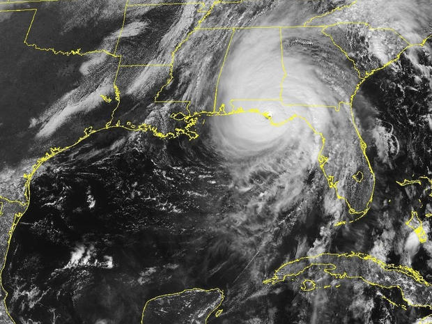
Hurricane Michael made landfall in the Florida Panhandle Wednesday afternoon. The intense Category 4 hurricane was packing top sustained winds of 155 mph when it crashed ashore in the early afternoon near Mexico Beach.
The National Hurricane Center described Michael as "potentially catastrophic." Michael was the worst storm ever to hit the Panhandle.
Nearly 30 million people in the Southeast were in its crosshairs. Forecasters said Michael was bringing damaging winds and potentially life-threatening storm surge.
- List of shelters in Florida, Alabama, Georgia
- Michael is a Category 4: Here's what the hurricane ratings mean
Read Hurricane Michael updates below as they happened:
Hurricane Michael by the numbers
- Hurricane history: first Category 4 hurricane to make landfall in Florida's Panhandle since record-keeping began in 1851. With a minimum pressure of 919 millibars in the hurricane's eye, it was the third most intense hurricane landfall in the U.S. in recorded history
- Wind speeds at 7 p.m.: 100 mph, with gusts topping 60 mph at several Georgia airports
- Current location: 35 miles west-southwest of Albany, Georgia
- High tides: storm surge of 6 feet up to 14 feet forecast for Florida's Panhandle and Big Bend
- Get out: roughly 375,000 people in Florida warned to evacuate
- Staying safe: nearly 6,700 people took refuge in 54 shelters in Florida
- Power outages: 370,060 customers without power in Florida, Alabama and Georgia
- Food and water: 1.5 million ready-to-eat meals, 1 million gallons of water and 40,000 10-pound bags of ice ready for distribution
"CBS Evening News" anchor Jeff Glor is in Florida
Jeff Glor will anchor Wednesday's "CBS Evening News" from Panama City Beach, Florida.
Watch on your CBS station or affiliate, or stream "Evening News" on CBSN tonight at 10 p.m. ET.
Gov. Rick Scott: "100 percent is focused on search and rescue"
Florida Gov. Rick Scott held a briefing at 6 p.m. ET hour to say officials are "100 percent focused on search and rescue."
He had earlier warned Floridians: "We are still in the midst of a Category 4 catastrophic and historic storm."
Power outages widespread in Florida, Georgia, Alabama
CBS News reports approximately 288,502 customers are without power in Florida, approximately 40,557 customers without power in Georgia and approximately 41,001 customers without power in Alabama.
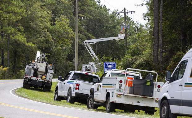
Duke Energy, the country's No. 2 power company that has customers in the path of Hurricane Michael, said the storm could cause some 300,000 to 500,000 power outages. "Complete power restoration from a storm of this magnitude could take several days," the company wrote on its website.
Customers can report power outages by visiting duke-energy.com, texting OUT to 57801 or calling 1-800-228-8485.
Latest Hurricane Michael forecast as of 5 p.m. ET
The National Hurricane Center said Hurricane Michael is moving further inland, but it remains an extremely dangerous hurricane with many different hazards.
NHC reports in its latest advisory there is "life-threatening storm surge" along portions of the Florida Panhandle, Big Bend and Nature Coast. They pointed out the worst of it will be located between Tyndall Air Force Base and Aucilla River -- where 5 to 10 feet of surge is ongoing.
NHC also mentioned that Michael will continue to produce "life-threatening flash flooding" in the Florida Panhandle and Big Bend regions and into portions of southeast Alabama, Georgia, North and South Carolina and southeast Virginia.
NHC warned Michael will produce "life-threatening hurricane-force winds" across portions of the Florida Panhandle, southeast Alabama and southwestern Georgia tonight as the "core of the hurricane continues to move inland."
Florida governor: "Continue sheltering in place"
Florida Gov. Rick Scott used a tweet to warn Floridians: "We are still in the midst of a Category 4 catastrophic and historic storm."
"Stay inside until directed further so that our recovery teams can move in as quickly as possible," he added.
Trump heads to Pennsylvania for campaign rally
President Trump is sticking to his campaign schedule as Hurricane Michael rakes across Florida. The president left the Oval Office at 3:52 p.m. ET on his way to Erie, Pennsylvania, for a "Make America Great Again" rally, CBS News' Sara Cook reports.
"I cannot disappoint the thousands of people that are there - and the thousands that are going," Mr. Trump said on Twitter. The rally is scheduled to start at 7 p.m. ET.
The president waved to White House reporters, but didn't respond to questions as he walked to Marine One, Cook reports. Earlier Wednesday, Mr. Trump said that he may visit areas affected by Michael early next week.
Michael to stay strong despite moving inland
The director of the National Hurricane Center said Michael was going to keep its strength even as it moves into Alabama and Georgia. By 4 p.m. ET, Michael had top sustained winds of 140 mph as its core moved over Florida's Panhandle, down from 150 mph an hour earlier.
Michael made landfall near Mexico Beach, Florida, earlier Wednesday afternoon with 155 mph winds. The hurricane center's Director Ken Graham said that when a storm comes ashore with winds that strong, "it's going to stay a hurricane for a while."
Michael's large size means its winds will continue pushing storm surge inland as well. The hurricane center said a National Ocean Service water level station in Apalachicola has reported storm surge of nearly 8 feet above ground.
Nearly 6,700 people in Florida shelters, gov. says
Nearly 6,700 people were in Florida shelters as Hurricane Michael was making landfall, according to a statement from Gov. Rick Scott's office. The state had 54 shelters open.
The state estimated that more than 375,000 Floridians were ordered to evacuate, but officials had expressed concerns about people not heeding evacuation orders. On Wednesday morning, Scott announced that it was too late for people in coastal areas to evacuate and that they should seek shelter instead.
At noon ET, 29,981 power customers had lost electricity, according to Scott's statement. Duke Energy had said Tuesday that it expected between 100,000 and 200,000 of its customers in the Panhandle to lose power.
Michael intensified as it was making landfall
The National Hurricane Center said Michael intensified as it was making landfall near Mexico Beach, Florida, as a catastrophic Category 4 hurricane, pushing a deadly storm surge and whipping the coast with 155 mph winds. Less than an hour before the storm made landfall, the hurricane center said Michael had top sustained winds of 150 mph.
Forecasters mark landfall as the place and time when the center of the eye strikes land. Minutes earlier, Michael's eyewall came ashore between Panama City and St. Vincent Island, and the hurricane center warned everyone inside the relative calm of the eye not to venture outside.
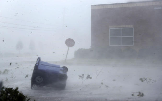
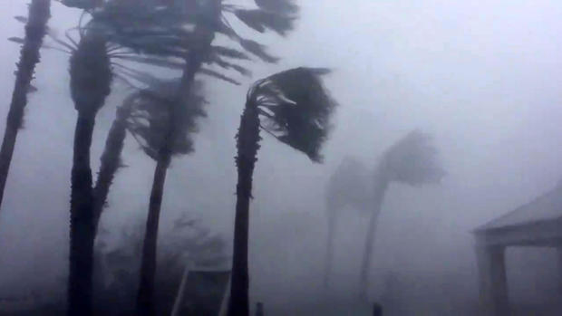
Hurricane-force winds extended outward up to 45 miles from the center. Those winds were tearing some buildings apart in Panama City Beach.
One beachfront structure under construction could be seen collapsing, and metal roofing material flew sideways across parking lots amid sheets of rain.
Trump may visit storm-affected areas next week
President Trump told reporters that he would look at visiting areas affected by Hurricane Michael on Sunday or Monday. Mr. Trump made the comments during a meeting with Homeland Security Secretary Kirstjen Nielsen and FEMA Administrator Brock Long in the Oval Office at the White House.
Mr. Trump said he would likely still travel to Erie, Pennsylvania, for a planned campaign rally Wednesday night. The president said that rally-goers had likely already lined up for the event.
Michael's core closing in on Panhandle's coast
At 11 a.m. ET, the National Hurricane Center warned that the core of Hurricane Michael was closing in on the Florida Panhandle's coast. In an advisory, the hurricane center said "life-threatening" storm surge, hurricane-force winds and heavy rainfall were imminent for the area.
The storm's center was located about 60 miles south-southwest of Panama City and about 65 miles west-southwest of Apalachicola, which are both on the Panhandle's coast. The storm was moving north-northeast at 14 mph.
The center warned that it was still possible for Michael to gain more strength before making landfall. Between 11 a.m. and 11:30 a.m. ET, Michael's maximum sustained winds increased from 145 mph to 150 mph.
"We looked at the records back to 1851," the hurricane center's Director Ken Graham told CBSN. "We can't find one that was a Cat 4 hitting the Panhandle, so you're talking about just dangerous winds."
At least 100K estimated to lose power in Panhandle
The country's No. 2 electricity company estimated that between 100,000 and 200,000 customers in the Florida Panhandle would lose power from Hurricane Michael. Duke Energy said Tuesday that some power outages could last several days to more than a week.
The company said flooding and crews' ability to access remote areas and islands would affect when power would be restored to some areas. Duke said it had over 7,000 workers mobilized for power restoration.
Customers can report power outages by visiting duke-energy.com, texting OUT to 57801 or calling (800) 228-8485.
FEMA most worried about storm surge, chief says
Storm surge in the Florida Panhandle is what FEMA is most worried about from Hurricane Michael, the agency's Administrator Brock Long said on "CBS This Morning" on Wednesday. Forecasters said the storm surge could rise to as much as 14 feet in some areas.
Long said people who hadn't evacuated ahead of the storm were putting their lives in danger. "We saw this in Florence," he said, referring to the hurricane that hit North Carolina and South Carolina during the summer.
"We put the warnings out, and a large portion of people died in their vehicles driving over flooded-out roads even though we're saying turn around and don't drown," Long said. On Wednesday morning, Florida Gov. Rick Scott urged people who were still in an evacuation zone along the coast to seek refuge, saying that it was too late to evacuate.
People on coast urged to seek shelter, not evacuate
Florida Gov. Rick Scott said on Twitter Wednesday morning that "the time for evacuating along the coast has come and gone." "CBS This Morning" co-host John Dickerson asked Scott what people should do if they were about to evacuate and see that statement.
"You've waited too long," Scott said. "You've got to hunker down. You've got to get to shelter as quickly as you can. This thing is coming ... it's getting worse."
Scott said that people in places like Tallahassee, which is not on the coast, had a small amount time left to evacuate but not much. "We're going to have hurricane-force winds even in a place like Tallahassee," Scott said.
Amtrak service disrupted
Amtrak is adjusting service to Florida for the safety of its passengers and employees because of Hurricane Michael.
Silver Star trains traveling from New York to Miami will operate from Miami to Jacksonville, Florida, beginning Wednesday and the Palmetto, which runs between New York and Savannah, Georgia, will operate between New York and Washington beginning Thursday.
Amtrak is waiving fees for passengers who change their reservations.
Some Panhandle residents told to stay put
Residents of the Florida county that includes Panama City who haven't evacuated are being told to ride out Hurricane Michael wherever they are:
Dire warning from Florida's governor
Florida Gov. Rick Scott has told residents in Michael's likely path time is of the absolute essence:
Air Force base in Michael storm surge sights
Some of the worst storm surge from Category 4 Hurricane Michael is expected to hit Florida's Tyndall Air Force Base, which has ordered all non-essential personnel to evacuate.
The National Hurricane Center's latest forecast shows as much as 13 feet of water on top of the usual waves and tides could inundate the base, which is home to more than 600 families and on an island about 12 miles east of Panama City.
All base residents were ordered to leave when Tyndall moved to "HURCON 1" status as the storm closed in.
The base provided transportation but limited families to one large piece of luggage per family and one carry-on piece per person.
Tyndall is home to the 325th Fighter Wing.
Hurricane Michael speeding toward Fla. Panhandle
Hurricane Michael, which the National Hurricane Center describes as "extremely dangerous, " was moving steadily toward its forecast afternoon landfall over Florida's Panhandle as of 5 a.m. EDT on Wednesday -- with 140 mph sustained winds.
The NHC said the storm was some 140 miles south-southwest of Panama City, Florida and 130 miles southwest of Apalachicola,Florida, moving north at 13 mph.
The center said Michael could generate a "life-threatening" storm surge as high as 13 feet over some spots as well as up to a foot of rain in some areas.
Michael now "extremely dangerous" Category 4 hurricane
Hurricane Michael strengthened into a fierce Category 4 storm early Wednesday, with maximum sustained winds of 130 mph, the National Hurricane Center said.
Forecasters said Michael could produce a life-threatening storm surge as high as 13 feet in some areas and as much as a foot of rain in some spots.
As of 2 a.m., Michael was some 180 miles south-southwest of Panama City, Florida and about 170 miles southwest of Apalachicola, Florida, moving due north at a steady clip of 12 mph.
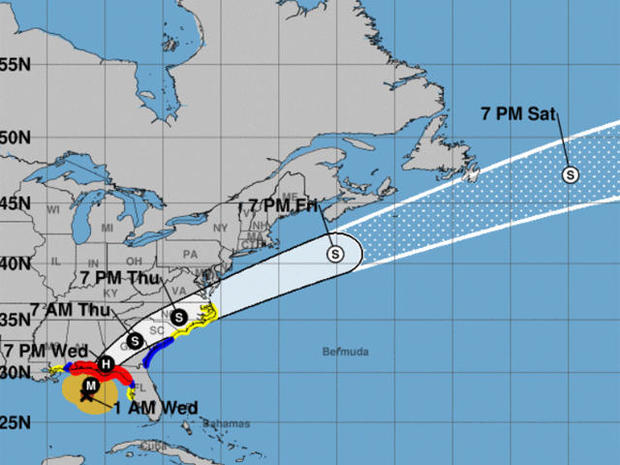
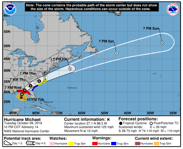
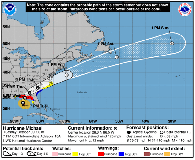
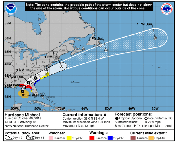
"On its forecast track," the center said, "the center of Michael will move across the northeastern Gulf of Mexico this morning. The center of Michael's eye is then expected to move inland over the Florida Panhandle or Florida Big Bend area later today, move northeastward across the southeastern United States tonight and Thursday, and then move off the Mid-Atlantic coast away from the United States on Friday."
" ... Some additional strengthening is possible today before Michael makes landfall in the Florida Panhandle or the Florida Big Bend area. Weakening is expected after landfall as Michael moves across the Southeastern United States."
Hurricane-force winds extended outward up to 45 miles from Michael's eye and tropical-storm-force winds extended outward up to 175 miles.
The NHC said Michael will also up the threat of tornadoes Wednesday for parts of the Florida Panhandle, the northern Florida Peninsula and Southern Georgia.
National Weather Service posts image of Hurricane Michael's eye
The National Weather Service in Tampa Bay tweeted an image of Hurricane Michael's eye, which is now close enough to be monitored by land based radar at Eglin Air Force Base in Okaloosa County, Florida.
FAA urges travelers to check with airliners for cancellations, delays
The Federal Aviation Administration told travelers ahead of Hurricane Michael's arrival to closely monitor their airliner for status updates.
On its website, the FAA says, "because of Hurricane Michael, airlines are likely to cancel many flights in the direct path of the storm and the surrounding areas. Flights that are not cancelled may be delayed. Once Hurricane Michael makes ground fall, airports may be listed as 'open', but flooding on local roadways may limit access to airports for passengers, as well as the employees who work for the airlines or at the airport."
FAA provided links to various airline companies to check flight status:
Hurricane Michael to become Category 4 storm before making landfall
NHC said in its 11 p.m. advisory Hurricane Michael is expected to become a Category 4 storm before it makes landfall in the Florida Panhandle or the Florida Big Bend area Wednesday.
That would mean maximum sustained winds would be at least 130 mph.
After making landfall midday Wednesday, Michael is expected to weaken as it moves across the southeastern United States.
The storm was located about 220 miles south-southwest of Panama City, Florida, and about 200 miles south-southwest of Apalachicola, Florida. Michael is moving north at about 12 mph, NHC said.
Trump retweets Florida Gov. Rick Scott's warning
Late Tuesday night, President Trump relayed an important Twitter message from Florida Gov. Rick Scott.
Scott urged Floridians in an evacuation zone "to leave RIGHT NOW" and to "not risk your life or the lives of your loved ones."
Hurricane Michael is expected to make landfall on the Florida Panhandle by midday Wednesday.
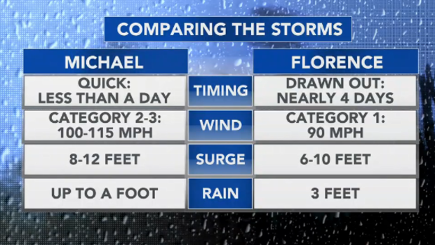
Comparing Hurricane Michael to Hurricane Florence
CBS News weather producer David Parkinson explained on CBSN the difference between the two most recent hurricanes to affect the United States.
Parkinson says Michael's landfall will be quick compared to Hurricane Florence, less than a day. Many Gulf Coast residents remember Hurricane Florence lingered for nearly four days.
It's also worthy to note Hurricane Michael will bring stronger winds than Hurricane Florence.
Hurricane Michael's forecast as of 8 p.m. ET
NHC released its 8 p.m. ET advisory to say that Hurricane Michael is becoming a better organized storm as it nears the Florida Panhandle.
Forecasters say Michael is expected to be near Category 4 when it makes landfall in the Florida Panhandle or the Florida Big Bend Area, NHC said.
Michael was located about 235 miles south-southwest of Apalachicola, Florida, pacing maximum sustained winds of 120 mph (unchanged since the last advisory).
Florida residents prepare for Hurricane Michael
Business and home owners in the Florida Panhandle rushed to fill sandbags and board up windows, CBS News' Omar Villafranca reports. Ambulances in Madison, Florida, are gassing up to be ready to respond to the Category 3 hurricane.
"We got to spend a couple of days here, only one day, hoping to wait it out," Nick Gillham told CBS News. His family, from Kentucky, aren't taking any chances and are cutting their beach trip short.
In Cedar Key, emergency sirens warn residents to leave by 8 p.m. Tuesday. Hundreds of thousands of people living near the shore have been ordered to evacuate, Villafranca reports.
Hurricane Michael has destructive, life-threatening storm surge
The National Hurricane Center has issued a warning about storm surge for the Florida Panhandle, Big Bend and Nature Coast.
NHC said the worst storm surge is expected to be between Mexico Beach and Keaton Beach where forecasters say 9 to 13 feet is possible.
Hurricane Michael's forecast as of 5 p.m. ET
The NHC said Michael has strengthened into a major hurricane, Category 3, with maximum sustained winds of 120 mph. As of 5 p.m. ET Tuesday, it was located about 295 miles south of Panama City and about 270 miles south-southwest of Apalachicola, Florida. The storm is moving north at about 12 mph.
The NHC said Michael's center will move across the eastern Gulf of Mexico tonight.
The center of the storm is then expected to move inland over the Florida Panhandle or Florida Big Bend area Wednesday, and then move northeastward across the southeastern United States Wednesday night and Thursday. It's forecast to move off the Mid-Atlantic coast and away from the United States on Friday.
Potential rainfall from Hurricane Michael
Forecasters said Huricane Michael could bring 3 to 6 inches of rain to Georgia, North and South Carolinas and Virginia, triggering flash flooding in a corner of the country still recovering from Florence.
"I know people are fatigued from Florence, but don't let this storm catch you with your guard down," North Carolina Gov. Roy Cooper said, adding, "A number of homes have rooftop tarps that could be damaged or blown away with this wind."
While Hurricane Florence wrung itself out for days and brought ruinous rains, fast-moving Michael is likely to be more about wind and storm surge.
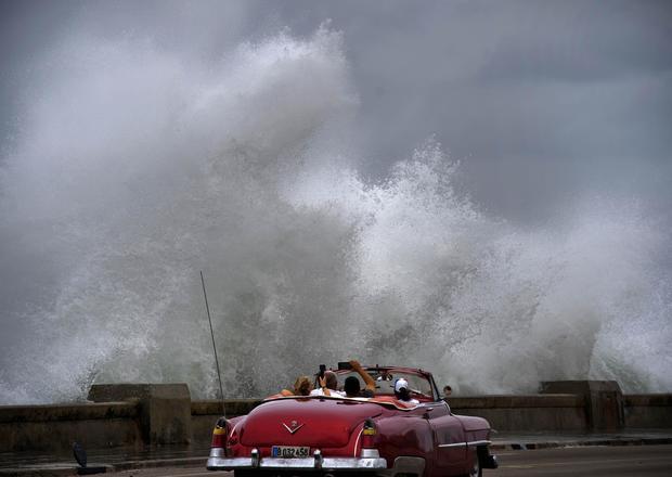
As Michael closed in on the U.S., it caused havoc in the Caribbean.
In Cuba, it dropped more than 10 inches of rain in places, flooding fields, damaging roads, knocking out power and destroying some homes in the western province of Pinar del Rio. Cuban authorities said they evacuated about 400 people from low-lying areas.
Disaster agencies in El Salvador, Honduras and Nicaragua reported 13 deaths as roofs collapsed and residents were carried away by swollen rivers.
Watches and warnings for Hurricane Michael
A Hurricane Warning is in effect from the Alabama-Florida border to Suwannee River, Florida.
Tropical Storm Warnings have been issued for the following areas
- From Fernandina Beach, Florida, to South Santee River, South Carolina;
- From the Alabama-Florida border to the Mississippi-Alabama border;
- From Suwanee River Florida to Chassahowitzka Florida.
Tropical Storm Watches have been issued for the following areas
- From South Santee River, South Carolina, to Duck, North Carolina, including Pamlico and Albemarle Sounds;
- From Chassahowitzka to Anna Maria Island, Florida, including Tampa Bay;
- From the Mississippi-Alabama border to the mouth of the Pearl River.
Mandatory evacuations
Mandatory evacuation orders went into effect for some 120,000 people in Panama City Beach and across other low-lying parts of the Gulf coast. The mandatory orders affected people in Bay County, Citrus County, Dixie County, Franklin County, Gulf County, Jackson County, Levy County, Okaloosa County, Taylor County, Wakulla County and Walton County.
More information on evacuation orders was available on the Florida Division of Emergency Management's website. Officials in Bay County said Tuesday they had not seen a rush of evacuees clogging roads inland -- a worry just hours before Michael's expected landfall.
Bay County Sheriff Tommy Ford said he's "not seeing the level of traffic" he would expect when three-quarters of the county's residents are under mandatory and voluntary evacuation orders. At a press conference, Scott urged Floridians to heed evacuation orders.
"Evacuations are not fun," Scott said. "They're not convenient. There's nothing good about evacuations other than it's going to save your life."
"CBS Evening News" anchor Jeff Glor in Florida
Jeff Glor anchors Tuesday's "CBS Evening News" from Panama City Beach, Florida, as Hurricane Michael approaches the Florida Panhandle.
Watch on your CBS station or affiliate, or stream "Evening News" on CBSN tonight at 10 p.m. ET.

