Hurricane Dorian pummels Bahamas as monster Category 5 storm
Hurricane Dorian fast facts:
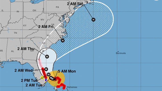
- As of 5 a.m. EDT Monday, the National Hurricane Center said Dorian was a Category 5 storm battering the Bahamas.
- Forecasters say Dorian may spare the U.S. a direct hit, but will move close to Florida's east coast late Monday.
- Mandatory evacuations were underway in some parts of Florida and ordered for later Monday for the coastlines of South Carolina and Georgia.
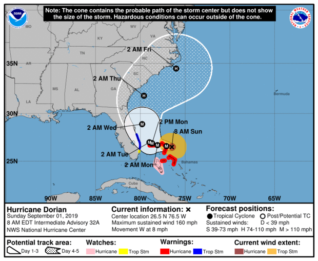
"Devastating" Hurricane Dorian was battering parts of the Bahamas overnight with punishing 165 mph maximum sustained winds -- down from 185 mph earlier -- and inching along on its path of destruction, the National Hurricane Center said.
Storm surges in some places were raising water levels more than 20 feet above normal.
Dorian was ripping off roofs, overturning cars and tearing down power lines as people hunkered down in schools, churches and shelters.
Though the hurricane center was still forecasting that Dorian would stay just off the U.S. coast as it makes its way up the seaboard, evacuations were ordered for parts of Florida and, later on Monday, the Georgia and South Carolina coasts.
Acting DHS chief Kevin McAleenan said Sunday that even if the storm remains just off the U.S. mainland, it could still cause major problems with high winds, a devastating storm surge and heavy rain.
As of 5 a.m. EDT Monday, Dorian's center was some 40 miles east of Freeport, Grand Bahama Island and some 115 miles east of West Palm Beach, Florida, the hurricane center said. The storm was barely budging, moving west at about 1 mph.
According to The Associated Press, Dorian tied the record for the most powerful Atlantic hurricane ever to come ashore in the Bahamas, equaling the Labor Day hurricane of 1935, before storms were named.
Follow live coverage of the storm below:
Grand Bahama Island feeling all of Dorian's wrath
The National Hurricane Center said at 5 a.m. EDT Monday that on its current track, "The core of extremely dangerous Hurricane Dorian will continue to pound Grand Bahama Island through much of today and tonight. The hurricane will move dangerously close to the Florida east coast tonight through Wednesday evening.
" ... Although gradual weakening is forecast, Dorian is expected to remain a powerful hurricane during the next couple of days."
Maximum sustained winds were near 165 mph with higher gusts.
Dorian unrelenting over Bahamas
Parts of Grand Bahama island were being lashed incessantly with destructive hurricane-force winds overnight as the Category 5 storm slowed to less than a crawl, moving west at a mere mile-per-hour, the U.S. National Hurricane Center said.
Sustained winds were down somewhat to 165 mph as of 4 a.m. EDT but gusts ranged as high as 200 mph. The storm surge was reaching 18- to 23-feet above normal tide levels, with higher destructive waves.
"This is a life-threatening situation. Residents on Grand Bahama Island should not leave their shelter when the eye passes over, as winds will rapidly increase on the other side of the eye. Residents in the Abacos should continue to stay in their shelter until conditions subside later today," the center warned.
"These hazards will continue over Grand Bahama Island during most of the day, causing extreme destruction on the island," the center added.
"Catastophic" storm surge on Grand Bahama?
Grand Bahama Island was probably getting hit with "catastrophic storm surge flooding" from Hurricane Dorian, the U.S. National Hurricane Center said at 1 a.m. EDT.
"This is a life-threatening situation," the center said. "Residents on Grand Bahama Island should not leave their shelter when the eye passes over, as winds will rapidly increase on the other side of the eye. Residents in the Abacos should continue to stay in their shelter until conditions subside later today."
Wind gusts over 200 mph were being recorded, along with a storm surge 18- to 23-feet above normal tide levels with higher destructive waves.
"These hazards will cause extreme destruction in the affected areas and will continue for several hours," the hurricane center said.
Eye-popping rainfall amounts forecast
The National Hurricane Center says Dorian is expected to pour 12 to 24 inches of rain on the northwestern Bahamas through late this week, with some spots getting as much as 30 inches.
In addition:
-- Coastal Carolinas: 5 to 10 inches, with isolated areas getting 15 inches
-- Atlantic coast from the Florida peninsula through Georgia: 3 to 6 inches, with isolated totals of 9 inches
-- Southeastern Virginia: 2 to 4 inches, isolated 6 inches
-- Central Bahamas: 2 to 4 inches, isolated 6 inches
Evacuations ordered in several states
South Carolina Gov. Henry McMaster on Sunday ordered the evacuation of his state's entire coast. The order, which covers about 830,000 people, was to take effect at noon Monday, at which point state troopers were to make all lanes on major coastal highways one-way heading inland.
Georgia's governor, Brian Kemp, ordered evacuations for that state's Atlantic coast, also starting at midday Monday.
Authorities in Florida ordered evacuations in some vulnerable coastal areas.
North Carolina Gov. Roy Cooper warned his state that it could see heavy rain, winds and floods later in the week.
-- The Associated Press
Hurricane watch extended
The National Hurricane Center extended its warnings to additional parts of Florida.
According to the 11 p.m. ET Sunday advisory: "A Hurricane Watch has been extended northward from the Flagler/Volusia County Line to the Mouth of the St. Mary's River. A Storm Surge Watch has also been extended northward from the Flagler/Volusia County Line to the Mouth of the St. Mary's River."
Evacuation ordered for some Georgia coastal communities
Georgia Governor Brian Kemp on Sunday issued a mandatory evacuation order for some coastal communities, which is set to take effect at noon on Monday. The executive order extends the evacuation period to Monday, September 9 for "communities east of Interstate 95 in Chatham, Bryan, Liberty, McIntosh, Glynn and Camden Counties."
Port Canaveral to close Monday
Authorities announced that Port Canaveral in Florida would be closing at 8 a.m. on Monday due to "Zulu" hurricane conditions. The distinction, issued by the Coast Guard, means that the port may experience hurricane-force winds within 12 hours.
Port Canaveral is located approximately 45 miles east of Orlando and is considered to be the world's second-busiest port for cruises that offer "multi-day embarkations," according to the port's website.
More than 600 flights canceled
According to The Associated Press, more than 600 U.S. flights have been canceled for Monday as the nation prepares for Hurricane Dorian. Nearly half of those flights concerned routes either arriving or departing from Florida airports.
Fort Lauderdale-Hollywood International Airport announced on Sunday that it would be closing at noon on Monday "until further notice."
Cancellations also impacted North Carolina, Georgia, Maryland and other states. Approximately 336 flights were canceled for Sunday alone.
South Carolina governor orders thousands evacuated
South Carolina Governor Henry McMaster on Sunday ordered mandatory evacuations across the state, impacting an estimated 830,000 people. The evacuations will begin at noon on Monday and include seven counties: Beaufort, Berkeley, Charleston, Colleton, Dorchester, Horry and Jasper.
Those counties will also experience school and government building closures on Tuesday. To ensure speedy evacuations, officials are reversing the flow of traffic on major highways.
"We do not want people to be stuck on the highway," McMaster said during a Sunday press conference.
Abaco Islands report "catastrophic conditions"
"Catastrophic conditions" were reported in The Abaco Islands, according to The Associated Press, with a storm surge of up to 23 feet due to Hurricane Dorian, prompting residents to board up their homes and hotels to close. Officials commissioned boats to help ferry residents to bigger islands in the Bahamas.
Already, Dorian had damaged roofs, downed power lines and overturned vehicles in addition to unleashing floodwaters. Prime Minister Hubert Minnis told AP that some areas have flooded so intensely that "you cannot tell the difference as to the beginning of the street versus where the ocean begins."
"Dorian's fury now aiming toward Grand Bahama," NHC reports
The National Hurricane Center issued a 5 p.m. ET advisory on Sunday warning that Hurricane Dorian's "fury" had taken aim at Grand Bahama, the northernmost island in the country and one of its largest. The storm's movement slowed to 5 mph, though its maximum sustained winds remain at 185 mph.
Its intensity has prompted the NHC to issue new alerts for areas around Florida's east coast, including a Hurricane Warning extending from Jupiter Inlet to the Volusia/Brevard County Line. A Hurricane Watch has also been issued from the Volusia/Brevard County Line to the Flagler/Volusia County Line.
Palm Beach International Airport has canceled all its commercial flights scheduled for Monday in response to Hurricane Dorian.
Bahamas official calls Hurricane Dorian "situation that is hard to describe"
Joy Jibrilu, director general of the Bahamas ministry of tourism, told CBSN's Elaine Quijano that Hurricane Dorian is causing "deteriorating conditions with sea surges, buildings already losing roofs and a situation that is hard to describe." There is expected storm surge between 18 to 23 feet on the Bahamas, forecasters said and the surge will be accompanied by large and destructive waves.
"The Bahamas have been very proud of the fact that it was deeply prepared for hurricanes," she added. "We have been experiencing them more than we have liked, but I don't think anyone expected a hurricane of this intensity."
Jibrilu said the Bahamas have experienced wind gusts of more than 200 mph.
"We will only be able to assess the impact of the storm once it has moved off and we're able to see the extent of damage to Abaco and Grand Bahama," she told CBSN. "Abaco and Grand Bahama are surrounded by keys and are stunningly beautiful -- keys are very small islands -- we really pleaded with people to evacuate especially tourists," Jibrilu said. "The government has done a stellar job in getting people off the keys, low-lying areas, close to the areas prone to flooding ... and getting them into hurricane shelters."
Florida braces for Dorian
As Dorian appeared to track northward, Floridians wondered whether to breathe a sigh of relief. But as CBS News correspondent Mark Strassmann reported, after days of dire warnings, hurried preparations and last-minute stockpiling, coastal residents knew better on Sunday than to completely relax.
Dorian's heavy winds and coastal flooding were still potential threats.
As Strassmann reported, even if Dorian's physical damage ends up being less than expected, its menace has already been costly: businesses lost millions when tourists fled right before Labor Day weekend, leaving empty beaches. Airport closures and cancelled flights will prolong the losses into the week ahead.
Utility crews from further north were already on their way to Florida, Georgia and the Carolinas to help with any power outages.
Video taken from aboard the International Space Station on Sunday afternoon showed the daunting scale of Hurricane Dorian as it enveloped the Bahamas as a devastating Category 5 storm.
Cameras on the outside of the ISS shot the video as the station orbited over the Caribbean, showing it as a clearly defined circular mass of clouds, swirling around a large eye.
Dorian makes landfall in Bahamas
The National Hurricane Center in Miami said Sunday that Dorian made landfall in Elbow Cay at 12:40 p.m. ET.
Maximum sustained winds have increased to a monstrous 185 mph. The Hurricane Center said the arrival of the storm posed "a life-threatening situation" with hazards that would cause "extreme destruction."
Wind gusts were clocked at over 220 mph. The storm surge was measured at between 18 to 23 feet above normal tide levels.
Trump briefed on Dorian
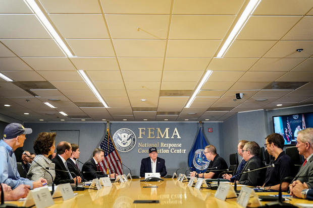
Ken Graham, director of the National Hurricane Center, told President Trump and other senior U.S. officials today via a live web link that Hurricane Dorian was a "textbook case of a very powerful hurricane."
He warned that the storm was so large that it could wreak significant damage even far from its eye.
"The big question," Graham said, was where the storm actual ends up turning to the east, out into the Atlantic, as it heads north along the U.S. coast.
"We're gonna be dealing with this hurricane, really all week," he said, predicting widespread storm surge and rainfall over eight inches in some places.
Graham said there was still "so much uncertainty" over the forecast track because even a tiny variance in the storm's behavior could change it's path significantly.
Catastrophic conditions in the Bahamas
The National Hurricane Center said Dorian became the strongest hurricane in modern records to hit the northwestern Bahamas on Sunday.
The center warned that catastrophic conditions were occurring in the Abaco Islands, in the Bahamas, as the storm moved slowly to the west.
Bahamian Prime Minister Hubert Minnis said Sunday was "the saddest day of my life."
Trump urges Southeast to "BE CAREFUL!"
After retweeting a series of advisories from the National Hurricane Center and other accounts on Sunday morning, President Trump sent a more personal message to residents of the Southeast: Be careful.
He said Hurricane Dorian appeared to be heading to Florida, South Carolina, North Carolina, Georgia and Alabama, and that it could "hit (much) harder than anticipated. Looking like one of the largest hurricanes ever."
"BE CAREFUL!" Mr. Trump urged, adding simply, "GOD BLESS EVERYONE!"
DHS chief says Dorian might stay off U.S. coast
Acting Homeland Security Secretary Kevin McAleenan told CBS News "Face the Nation" moderator Margaret Brennan on Sunday that the monster hurricane churning in the Caribbean could remain just off the coast of the United States, but he warned it could still cause major problems.
"Most models show it holding for over 24 hours (over the Bahamas) before it starts moving in a northerly direction and staying most likely offshore of Florida, Georgia, and South Carolina," McAleenan said.
"That does not mean there's not going to be significant impacts from the storm where you expect to see hurricane force winds lashing the coastline of Florida as soon as Tuesday," he added, noting that storm surge was expected to pose a major threat and there could also be "a prolonged rain event as the storm makes its way north."
McAleenan said he was "regularly" briefing President Trump on the storm, and that he expected to do so again, along with other key cabinet members, later Sunday morning.
The acting DHS chief also defended the Trump administration's decision to divert millions in disaster relief funds to the southern border for immigration enforcement as his agency prepares to respond to the powerful storm.
In an interview Sunday on "Face the Nation," Acting Homeland Security Secretary Kevin McAleenan said that the expected transfer of more than $155 million funds from the Federal Emergency Management Agency (FEMA) would have "no impact" on his department's response to the hurricane.
Palm Beach County evacuations ordered
Palm Beach County, Florida authorities issued mandatory evacuation orders on Sunday morning as Hurricane Dorian churned toward the state's east coast as a potentially devastating Category 5 storm.
In an alert sent to residents, officials said anyone living in the county's designated "Zones A or B" should leave immediately.
The two zones include people living in mobile or" sub-standard housing," and low-lying areas prone to flooding. It also includes the barrier islands, land areas north and south of the Jupiter Inlet, and other areas vulnerable to storm surge south along the Intracoastal Waterway to the Broward County line.
Dorian could stall over Bahamas
Weather forecasters said early Sunday that if Hurricane Dorian slowed to a crawl over the Bahamas as predicted later in the day, it could complicate their outlook for the southeastern U.S. coastline.
The National Hurricane Center said Dorian could nearly stall over Great Abaco Island or Grand Bahama Island for more than 24 hours late Sunday. Hurricane Center Director Ken Graham said that would be catastrophic for the island chain.
Forecasters say ocean levels could rise up to 20 feet in parts of the northern Bahamas with the storm surge topped with huge waves.
With reporting from The Associated Press.
Now-Category 5, Dorian roars toward Bahamas
Dorian grew into a huge Category 5 storm early Sunday morning, set to rake over the Bahamas with potentially devastating 160-mile-per hour sustained winds and gusts even higher.
The National Hurricane Center warned that the Bahamas would feel the fury of the storm within just hours, and while fluctuations in Dorian's intensity were expected, it was likely "to remain a powerful hurricane during the next few days" as it barrels north toward Georgia and the Carolina coasts.
"Significant impacts could also occur even if the center of #Dorian stays offshore," the Hurricane Center said, adding that "the risk of strong winds and life-threatening storm surge is increasing along the coasts of Georgia and South Carolina during the middle of next week."
Orlando Airport lifts planned Monday closure
Orlando International Airport issued a statement on Saturday announcing it had lifted its plan to close on Monday, September 2 and will continue normal operations.
"The airport's Emergency Operations Center will continue 24 hour a day monitoring of Hurricane Dorian and airport leaders will work with industry partners to determine if any further adjustments to airport operations plans are necessary," a statement issued by Orlando Airport noted.
What supplies do you need to prepare?
The National Weather Service is encouraging anyone in the path of the storm that it's "never too early" to start preparing a hurricane kit. CBS News has rounded up some emergency preparedness tips for people and pets, as well as a checklist of supplies to have on hand before a big storm arrives. Ahead of potentially devastating storms this hurricane season, the Red Cross recommends having several supplies including, a flashlight, batteries, first aid kit, medications, a multi-purpose tool and an emergency blanket.
NOAA radar shows eye of Hurricane Dorian
The NOAA Hurricane Hunters released an image Saturday evening showing the eye of Hurricane Dorian. The National Hurricane Center reaffirmed its Category 4 status at the time.
Florida "not out of the woods," DeSantis said
Florida Governor Ron DeSantis encouraged residents, especially those on the east coast of the state, to "remain vigilant" as Hurricane Dorian continues making its way west."We're not out of the woods yet," DeSantis said during a Saturday evening press conference.
"So our posture here is we're encouraged by the last 24 hours... but we're also preparing for the fact that that cone of uncertainty still includes a lot of areas on the east coast of Florida and even into central and northern Florida."
During a Sunday press conference, DeSantis encouraged those in evacuation zones to "heed that call."
"This storm at this magnitude could really cause massive destruction," DeSantis said. "Do not put your life in jeopardy by staying behind when you have a chance to get out."
Pets evacuated from South Carolina coast are up for adoption
Officials at a northern South Carolina humane society say hundreds of pets are up for adoption after being evacuated from facilities along the coast, CBS affiliate WSPA reported. The Greenville Humane Society now has more than 200 animals up for adoption and officials said they're in need of volunteers.
"Its very hard on our staff and our staff absolutely love these animals and it can be stressful for the animals as well," said Rachel Delport, who works at the center in Greenville.
Trump meets with FEMA officials at Camp David
President Trump on Saturday met with FEMA officials at Camp David to discuss the response to Hurricane Dorian. Mr. Trump canceled a weekend visit to Poland to plan for the potentially catastrophic storm that could affect more than 20 million Americans.
Mr. Trump briefly left Camp David to visit Trump National Golf Club in Sterling, Virginia, on Saturday morning, according to pool reports. He returned to the presidential retreat Saturday afternoon.
White House press secretary Stephanie Grisham said the president has been briefed hourly on the storm and that he "participated in several phone calls." When asked about a video posted by The Hill claiming to show Mr. Trump golfing, Grisham said, "I have no idea what that video is."
Mr. Trump on Saturday retweeted several tweets by the National Hurricane Center, FEMA and the American Red Cross providing information about the storm. He also warned in a tweet that South Carolina "could get hit MUCH harder than first thought."
Meet NOAA's first all-female hurricane hunting crew
While Hurricane Dorian makes its way toward the Florida coast, not everyone is fleeing the fierce storm. Commander Rebecca Waddington, Lieutenant Lindsey Norman and Captain Kristie Twining flew into the eye of the storm this week.
Their hurricane hunter aircraft collects data for NOAA, which helps forecasters predict where the storm is heading next. But their flight Thursday was historic. It was the first time in NOAA's history that a Hurricane Hunter's flight crew was comprised of all women.
"There are more women getting interested in flying and it's also fun to have that camaraderie because to be honest it's been a male-dominated field," Captain Kristie Twining said.
Twining hopes they will inspire a new generation of female pilots.
"To let them know this is something that is certainly a possibility for them and they don't have to feel intimidated or in anyway think that they cannot do it," Twining said.
"People think you're a little bit nuts, but when you tell him why we're going out and doing this, going out and collecting all of this really important data, then people are usually really grateful for what you're doing," Norman said.
-- Dana Jacobson reports
