North Texas skirts record highs as storm chances loom Friday
NORTH TEXAS (CBSDFW.COM) - It's still hot, but a little less humid than the last few days. The best advice -- stay hydrated and try to enjoy a few minutes outdoors, preferably earlier in the morning or in the early evening.
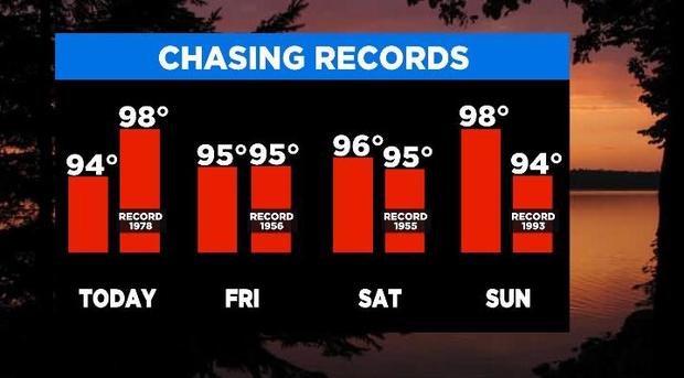
Thursday's forecast shouldn't be a record, but Friday through at least the middle of next week the Metroplex is forecasted to either tie or break the record high each day. It's an impressive summer weather pattern, just in mid-May instead of July.

The other thing to note is the chance for a few storms Friday evening, mainly west of DFW. Storms should start to develop around 5:00 p.m. or 6:00 p.m. out west. But as the weather pattern moves east the environment will be less favorable and the storms are expected to weaken and dissipate quickly.


A few of the storms west of U.S. Route 281 could produce 60 mph winds and quarter size hail, but the images above show just how quickly those fizzle out. Once we get to midnight, it's all over and then it's just about the sizzling hot temperatures into the weekend.