Winter storm set to freeze southeast Michigan this week


(CBS DETROIT) - A winter storm will bring hazardous impacts to southeast Michigan in the middle of this week.
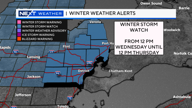
A Winter Storm Watch has been issued from noon on Wednesday through noon on Thursday due to the potential icy impacts.
This storm system will move in mainly during the afternoon hours Wednesday and will start as snowfall.
After a quick coating of snow, we'll make a change at the start of the evening commute (around 5 p.m.) over to sleet or freezing rain, or possibly both.
This change will significantly depend on the temperature we experience not just at ground level but also higher up.
As the evening goes on, we will see freezing rain and sleet as the dominant precipitation types leading to hazardous travel on ice covered roads.
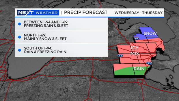
As the night progresses, these precipitation types begin to also see rainfall mix in especially south of I-94.
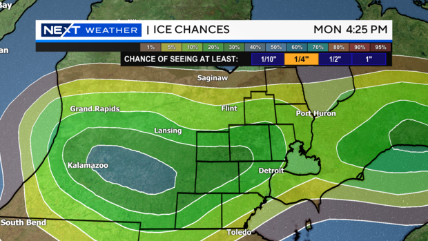
This means the primary corridor for ice coverage would be between I-94 and I-69.
Shifting with a system like this is common, which is why these layers are so broad right now.
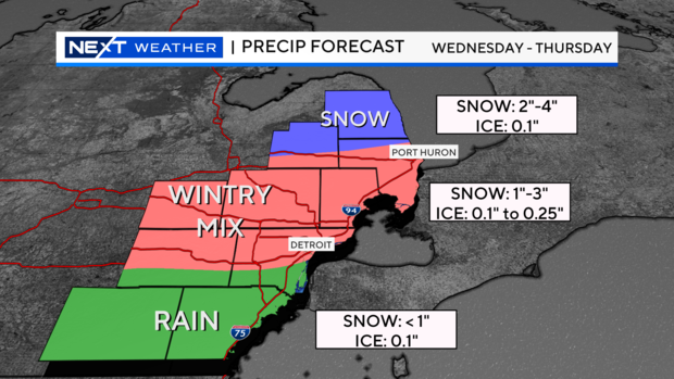
Anywhere north of I-69 expect mainly snow will snowfall accumulations coming in generally around 2 to 4 inches.
For Monroe and Lenawee counties, this will mainly be a rain event, however, the rain will be heavy at times, and you may even hear a brief rumble of thunder. We are looking at around an inch of rainfall in these areas which could cause flooding. Plus, all the standing water may freeze over at night.
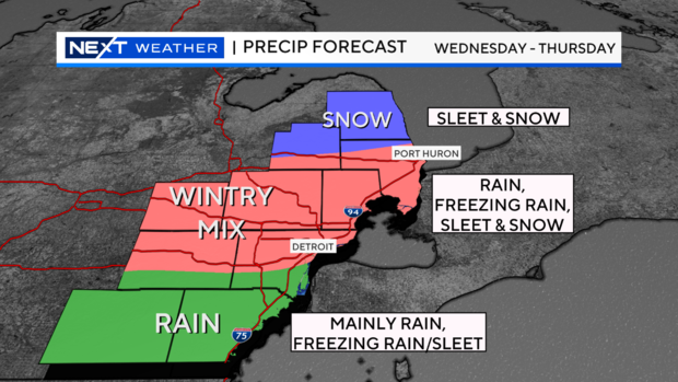
Some minor icing may happen also, with some freezing rain at times of the evening and overnight. Locations between I-94 and I-69 have the best likelihood of freezing rain, rain, and sleet.
This is all temperature dependent, high up in the atmosphere and near the surface which will help distinguish what type of precipitation we get and when.
We could get up to 0.25" of ice accumulation. This could easily break tree branches and powerlines, so we will keep you updated if and when those numbers come in.
Your NEXT Weather team will continue to fine-tune the forecast as we get closer.
With that being said, plan for hazardous travel at least on Wednesday evening through the morning hours on Thursday, and likely longer on roads that won't receive treatment right away.
Some power outages are possible due to the weight of ice on spans.
Half an inch of ice on a normal residential span can add more than 500 pounds to the weight of the line.
Wind plays another factor where a stronger breeze adds on to weaken power lines or tree branches.
Our best chance at a quarter-inch of ice remains in the central/western portions of southeast Michigan while the most likely spots for more would be from Jackson to Battle Creek (shown in the blue circle).
Our primary forecast concern that gives us a little pause would be the freezing line.
This is the area in the atmosphere that will be draped west to east across the region that is the divide between rain and cold precipitation.
Over the next 24 hours we'll get a much better idea on where specifically that line will set up and how it will move through the region.
Where that motion occurs is where you can expect the change from snow to sleet to freezing rain and then eventually rainfall.
Another factor is rainfall intensity and rainfall rate.
The heavier the rain falls the warmer the air gets around it and if this happens it would cut down on our ice amounts.
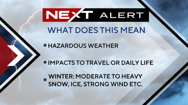
In anticipation of this system and the likely travel impacts we are declaring Wednesday as a NEXT Weather Alert Day.
This means we will be increasing our weather coverage in all shows, online, on our stream, and on social media.
We will also have crews in the field, including in our NEXT Weather Tracker vehicle, keeping an eye on conditions and taking readings that we use to continuously forecast the event.
Alert Days are only declared by us when hazardous weather is expected to impact travel or regular daily life, and it must meet a higher criteria than normal storm systems.
For example, we wouldn't issue this on a day where we get a couple of inches of snowfall.
Plan ahead now for hazardous travel during the late-afternoon and evening on Wednesday through the morning hours on Thursday.
Stay with the CBS Detroit NEXT Weather Team for the latest on the evolving forecast.