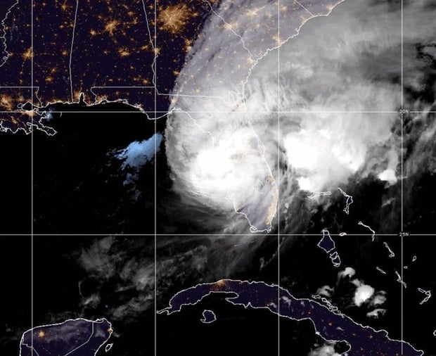
Maps show track of Hurricane Milton as it makes landfall in Florida
Update: Follow live updates on Hurricane Milton here, including the latest on the impact of the storm.
Hurricane Milton weakened slightly to a still-powerful Category 3 storm Wednesday as it made landfall along Florida's west-central Gulf Coast near Sarasota Wednesday night.
The storm made landfall at about 8:30 p.m. Eastern Time near Siesta Key in Sarasota County, the National Hurricane Center reported.
It was forecast to continue moving across the central part of the Florida peninsula overnight before exiting off the east coast of Florida into the Atlantic on Thursday.
"This is an extremely life-threatening situation," the hurricane center warned earlier.
CBS News Meteorologist Nikki Nolan said Milton would maintain hurricane status but rapidly weaken as it continues across Florida after losing the fuel of the warm Gulf waters. Out over the Atlantic it would quickly transition into a tropical storm.
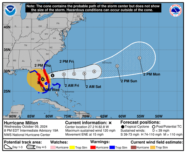
Milton reached Category 5 strength Monday with sustained wind speeds as high as 180 mph, in a rapid intensification the hurricane center called "remarkable."
The storm hit Florida as a Category 3 hurricane at 8:30 p.m. Eastern Time with maximum sustained winds of 120 miles per hour.
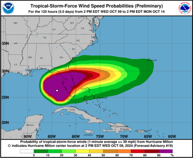
Forecasters warned the storm would cause destructive and potentially life-threatening storm surge along a large stretch of the coastline in addition to "devastating" hurricane-force winds.
It is forecast to drench a large part of a state still reeling from Hurricane Helene.
Hurricane Milton live radar map
This radar loop from CBS Miami shows weather conditions over Florida from Hurricane Milton.

Path of Hurricane Milton
A hurricane warning was in effect for the Florida west coast from Bonita Beach north to Suwannee River, including Tampa Bay — as well the state's east coast from the St. Lucie-Martin County line north to Ponte Vedra Beach.
A storm surge warning was in place for Florida's west coast from Flamingo north to Suwannee River, including Charlotte Harbor and Tampa Bay. The hurricane center warned Tuesday that storm surge in the Tampa Bay area could reach 10 to 15 feet above ground level, but that prediction shifted overnight as Milton's projected path turned a bit southward.
Forecasters said Wednesday that storm surges could reach 8 to 12 feet in around Tampa Bay — still a potentially catastrophic outcome — and 9 to 13 feet from Anna Maria Island southward to Boca Grande. The latter area covers almost 75 miles of coastline and includes Sarasota.
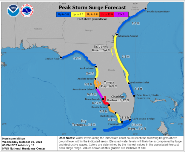
A storm surge warning was also in place on a stretch of the East Coast, from Sebastian Inlet, Florida, north to Altamaha Sound, Georgia, and several tropical storm watches warnings were also in effect for Florida, Georgia and South Carolina, along with Mexico and the Bahamas.
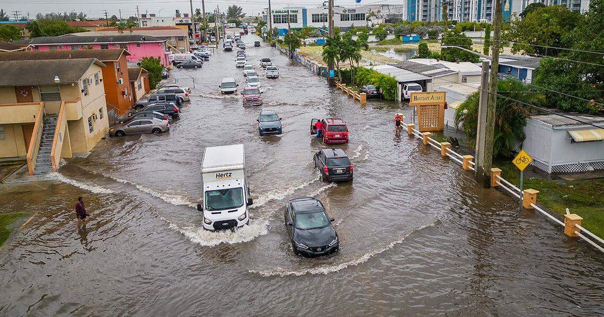
The National Hurricane Center warned of heavy rainfall of up to 18 inches across central and northern parts of the Florida Peninsula through Thursday, which could generate "catastrophic and life-threatening flash and urban flooding, along with moderate to major river flooding."
Nolan said the heaviest rainfall was expected along Florida's Interstate 4, with anywhere from 6 to 12 inches of rain, and up to 18 inches in some spots.
Florida officials prepare for impact
Florida Gov. Ron DeSantis urged residents Wednesday morning to seek shelter at local- or state-run centers if they hadn't already evacuated to another place, warning that "there will be fatalities" linked to the storm because some people will decide not to follow evacuation orders.
Speaking to CBS News Wednesday evening just ahead of Milton's arrival, DeSantis said that "by and large, people heeded the call" to evacuate. The governor also said that Florida was "absolutely" ready for Milton.
"We've got 50,000 linemen staged, ready for rapid power restoration," DeSantis said. "We also have a full mobilization of the Florida National Guard, as well as receiving a lot of assets from other states, so it will be the largest search and rescue function that we've ever done."
Kevin Guthrie, executive director of the Florida Division of Emergency Management. said the state was preparing "for the largest evacuation that we have seen, most likely since 2017, Hurricane Irma."
On Wednesday afternoon, the National Weather Service said, "It's time to shelter-in-place from #Milton. Tropical-storm force winds, flooding rains, and tornadoes are spreading inland across FL. Unless a life-threatening situation arises, stay indoors and follow updates."
"We're prepared for another horrible hurricane to hit Florida," President Biden, who has postponed a trip to Germany and Angola because of Milton, told reporters during a visit to Milwaukee Tuesday. "I've directed my team to do everything they can to save lives, help communities before, during and after this hurricane."
He advised Floridians to "follow safety instructions, including evacuation orders. You got to be safe because people are dying. People have died so far, not from this hurricane, but from the last one."