Heat wave in Southeast Michigan. What to know about the high temperatures this week.


(CBS DETROIT) - Southeast Michigan will experience a heat wave throughout the week, with temperatures predicted to reach the mid-90s.
According to the National Weather Service, a heat wave is when three consecutive days have temperatures reaching a high of at least 90 degrees each day. The last time Metro Detroit had a heat wave of four consecutive days with temps at 95 degrees or more was July 1-4, 2002
In response, the NEXT Weather team declared Monday through Friday as alert days due to the heat. Here's what to know about the temperatures and weather conditions each day.
Friday, June 21
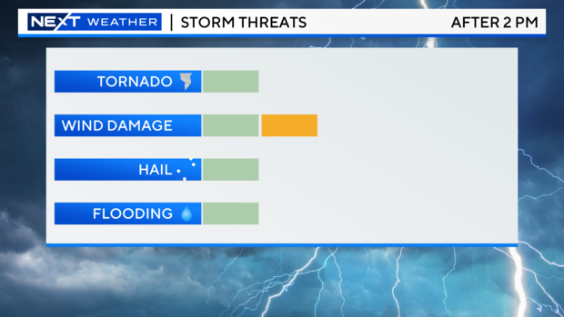
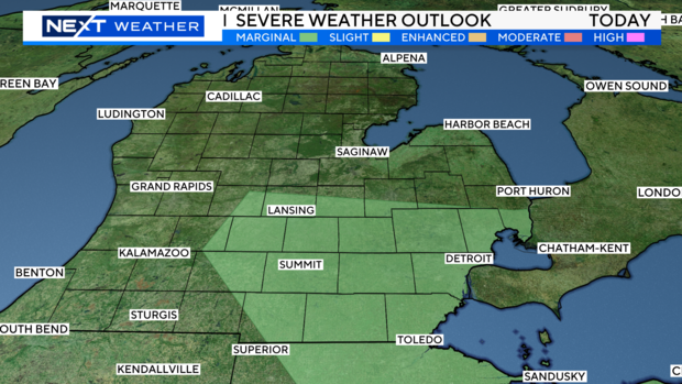
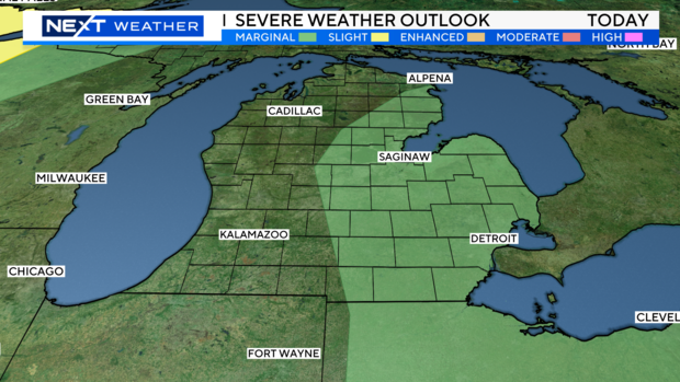
There is a risk of more strong to severe storms across Southeast Michigan for Friday.
The Storm Prediction Center has a large part of the area under a marginal (1/5) risk after 2 p.m. on Friday.

The main threat will be strong, damaging winds and localized flooding.
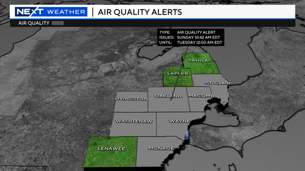
There is also an air quality alert for Livingston, Oakland, Macomb, St. Clair, Washtenaw, Wayne and Monroe counties.
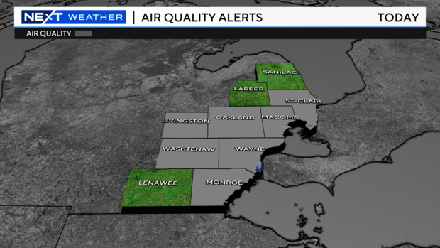
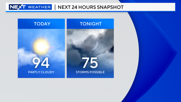
People with respiratory issues may have difficulties today due to the air quality. Temperatures will reach 90 degrees Friday and the mid-90s for Saturday. Highs are forecasted to be in the 80s next week.
Thursday, June 20
Dangerous heat and storms for another day across Southeast Michigan.
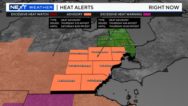
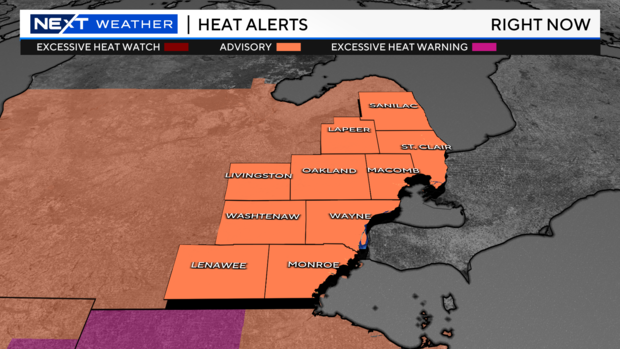
There is still a heat advisory in effect until 10 p.m. Thursday for Livingston, Oakland, Macomb, Washtenaw, Wayne, Lenawee and Monroe counties.
This means it will feel like 95 degrees or higher across those counties.
There is also a marginal risk for severe storms Thursday afternoon and evening. That's a 1/5 on the Storm Prediction Center's threat scale. This comes after storms rolled through Southeast Michigan Wednesday night, causing power outages and downed trees in several areas.
Thursday and Friday are both Next Weather Alert days because of the extreme heat. By Saturday, temperatures will warm to 93 degrees.
Humidity levels will be lower by the weekend.
Monday's High will be in the low to mid 80s.
Wednesday, June 19
More extreme heat for Southeast Michigan today.
The National Weather Service has dropped an excessive heat warning for the area, but all counties in Southeast Michigan are under a heat advisory.
This means many areas will feel like 95 degrees or higher. Some areas, including Metro Detroit, will feel closer to 100 to 105 degrees.
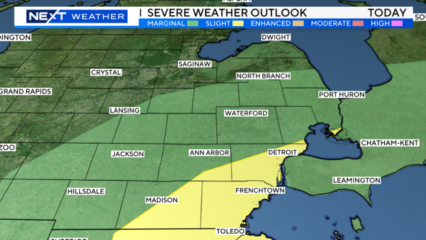
There is also a marginal risk and a slight risk for storms to pop up today for Southeast Michigan including the Detroit metro. The main concerns will be hail, strong wind gusts, and the potential for an isolated tornado.
The National Weather Service issued multiple severe thunderstorm warnings for Southeast Michigan on Wednesday.
Tuesday, June 18
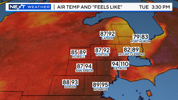
Today will be one of the hottest days of the week for Southeast Michigan, as temperatures climb into the mid-90s.
It will feel like 105 to 110 degrees for parts of Metro Detroit.
Because of the excessive heat and humidity, there will be a chance for a few strong to severe storms on Tuesday afternoon and evening.
The main threat will be some strong winds up to 60 mph or higher.
There is a marginal risk of storms on Tuesday afternoon and evening. This is a 1 of 5 on the severe scale from the Storm Prediction Center.
Even overnight lows tonight will be in the middle 70s, with high dew points. It will continue to feel like 80 degrees plus through the overnight with the rain and storms ending.
Temperatures will stay in the mid-90s all week with feels like temperatures staying near if not at 100-plus until the weekend.
By Monday, highs will be in the mid-80s, but late next week we could expect even warmer temperatures in the upper 80s.
Monday, June 17
Today is the first of a five-day heat wave.
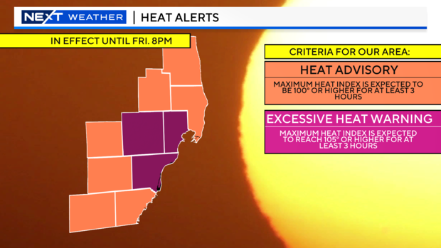
Already packing a punch with excessive heat warnings for Oakland, Macomb, and Wayne counties and a Heat Advisory in effect for the rest of Southeast Michigan. Both the warning and advisory will last through 8 p.m. Friday.
Excessive heat warnings mean the heat index will reach 105 degrees or more for three consecutive hours or more in a 12-hour period. A heat advisory means the heat index is expected to be over 100 degrees for three consecutive hours or more.
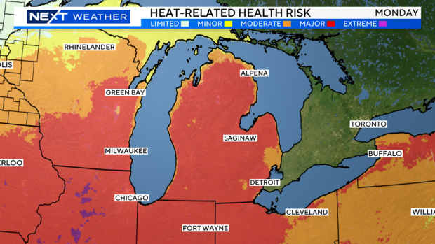
The heat-related health risk is also high this week. Today, we are under Category 3 (Red), which is a major risk. This impacts anyone without effective cooling and hydration and those in heat-sensitive industries.
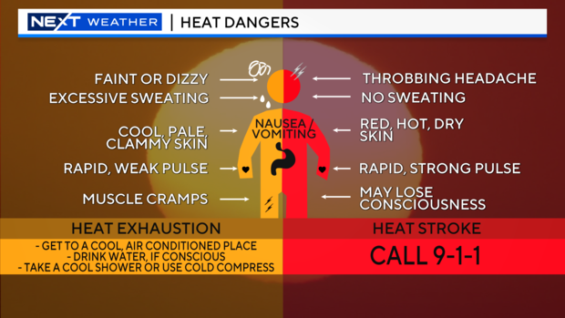
Heat dangers can be very serious, ranging from heat exhaustion to heat stroke. If you start feeling any of the symptoms of heat exhaustion, such as becoming faint or dizzy, muscle cramping, or a rapid, weak pulse, get somewhere cool, drink water, and rest. If you are not sweating, have a throbbing headache, a rapid, strong pulse, and red, hot, dry skin, then call 911.
In addition to the heat, an air quality advisory is also in effect for elevated levels of ozone. The advisory is in effect today for Wayne, Washtenaw, Macomb, Monroe, Oakland, Livingston, and St. Clair counties. Limiting refueling vehicles, using charcoal girls, and using gas-powered lawn equipment helps to limit ozone.
Sunshine is expected through the rest of today, however a chance for a shower or thunderstorm will be possible this afternoon and evening. Some of these storms could become strong to severe bringing chances for torrential rainfall, gusty winds up to 60 mph, and half an inch size hail. Heat and humidity will continue for the rest of today and tonight. Expect highs to reach to 94 degrees Monday with dewpoints in the upper 60s and the heat index as high as 105 degrees. Overnight lows will drop only into the low to mid-70s with the chance of showers and storms moving out after 1 a.m., but leaving us with partly cloudy skies and muggy conditions as dewpoints will hover around 70 degrees.
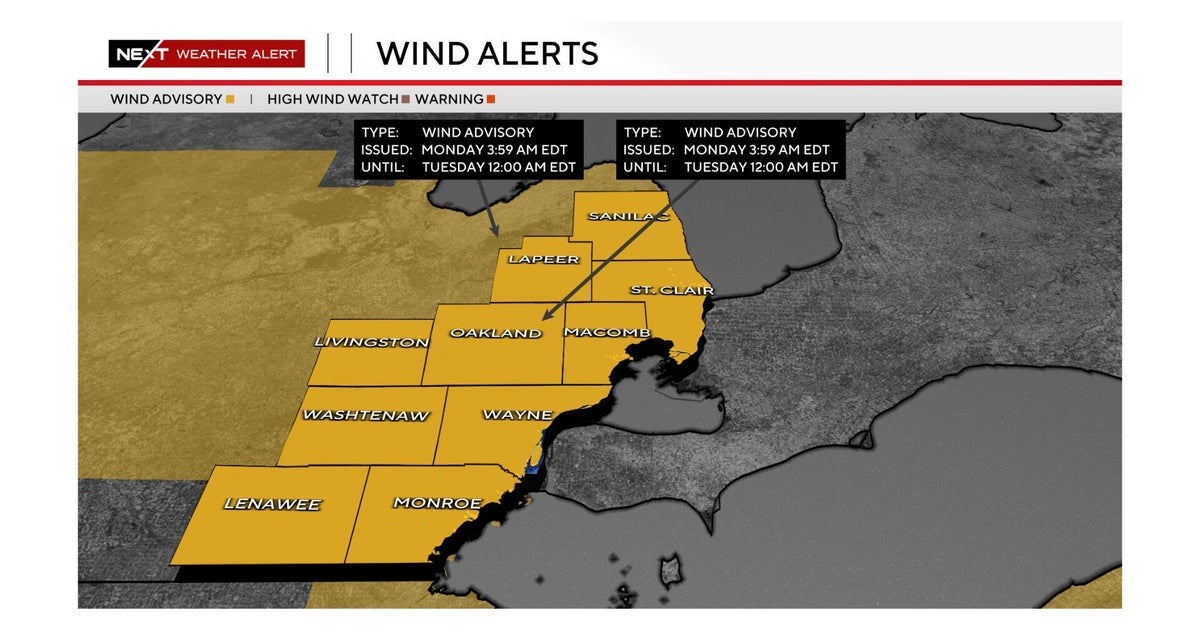
Multiple counties in Southeast Michigan, including Genesee, Lapeer, Macomb, Oakland, Washtenaw and Wayne counties, have opened cooling centers.
In Detroit, the city's health department opened 10 cooling centers in partnership with Detroit Recreation Centers and the Detroit Public Library.
On Monday, Kroger partnered with CBS News Detroit to give away 120 cases of bottled water to the public at three stores in the metro area. The effort was to keep residents hydrated as high heat hovers across the area.